Durham Bishopric Halmote Court Records: Maps
Introduction

Catalogue

Reference code: GB-0033-DHC11
Title: Durham Bishopric Halmote Court Records: Maps
Dates of creation: mostly 19th and early 20th century.
Extent: ca. 1,300 maps (boxed, rolled and flat) and 15 volumes (1 box)
Held by: Durham University Library, Archives and Special Collections
Origination: records of the Halmote Court, which administered the copyhold land and the tenants thereof belonging to the Bishopric of Durham, located mainly in Co. Durham but also in Northumberland and Yorkshire between about 1500 and 1952 when the the Court's office was finally closed.
Language: English

Further information on the Bishopric Halmote Court and its records is included within the collection level description.

There are almost no maps or plans of bishopric copyhold properties among the Halmote Court records predating the Ordnance Survey (O.S.) maps. Halmote Court officials coloured their office sets of the 6 inch and 25 inch O.S. series (DHC 11/I and III) to distinguish bishopric copyhold, leasehold and freehold land, and annotated them with the call numbers used to identify plots of copyhold land, and other administrative information. Working from the annotated maps, therefore, it is possible to discover the call numbers relating to particular areas, and from there go via the call books (DHC 1/V) to the records of transactions relating to those calls in the court rolls (DHC 1/I-III). Conversely, working from a call number it is possible to identify the location of the holding on a map.

DHC11/I: Annotated 6 inch O.S. maps of Co. Durham
DHC11/II: Books of reference to 25 inch O.S. maps of Co. Durham
DHC11/III: Annotated 25 inch O.S. maps of Co. Durham
DHC11/IV: Other O.S. series
DHC11/V: Miscellaneous maps and plans
DHC11/VI: Additional maps and plans


Catalogue

6 inch:1 mile Ordnance Survey of County Durham
Dates of creation: 1862-1865
Extent: 4 boxes
6 inch O.S. maps covering the whole of County Durham (1st edition), coloured to distinguish bishopric copyhold, leasehold and freehold land, and annotated with the call numbers used to identify plots of copyhold land, and other administrative information
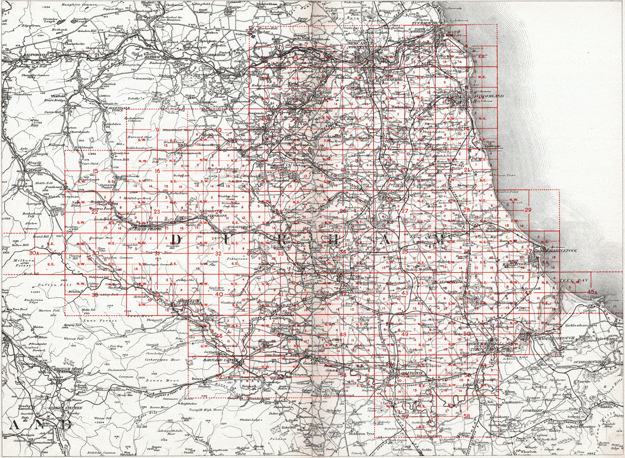
Sheets are numbered according to the county grid used by the Ordnance Survey. This is available online (copies available within the collections and in the search room at Palace Green Library), with each main grid square linked to a digital image of the numbered DHC 11/I plan from the list below.
These plans are all listed within the library catalogue.
Key map linked to Halmote Court annotated 6 inch OS plans

DHC11/I/A
Key to 6 inch and 25 inch Ordnance Survey of Durham.
Digitised material for Key to 6 inch and 25 inch Ordnance Survey of Durham. ca. 1860 - DHC11/I/A
DHC11/I/B
Plan of Sunderland and District.
Digitised material for Plan of Sunderland and District. ca. 1860 - DHC11/I/B
DHC11/I/1
Ryton. Crawcrook.
Digitised material for Ryton. Crawcrook. OS 6 inch map annotated in later 19th century to show Durham Bishopric Halmote Court property - DHC11/I/1
DHC11/I/2
Blaydon. Gateshead. Newcastle.
Digitised material for Blaydon. Gateshead. Newcastle. OS 6 inch map annotated in later 19th century to show Durham Bishopric Halmote Court property - DHC11/I/2
DHC11/I/3
Gateshead. South Shields. Jarrow.
Digitised material for Gateshead. South Shields. Jarrow. OS 6 inch map annotated in later 19th century to show Durham Bishopric Halmote Court property - DHC11/I/3
DHC11/I/4
South Shields. Souter Point.
Digitised material for South Shields. Souter Point. OS 6 inch map annotated in later 19th century to show Durham Bishopric Halmote Court property - DHC11/I/4
DHC11/I/5
Chopwell. High Spen.
Digitised material for Chopwell. High Spen. OS 6 inch map annotated in later 19th century to show Durham Bishopric Halmote Court property - DHC11/I/5
DHC11/I/6
Whickham. Burnopfield.
Digitised material for Whickham. Burnopfield. OS 6 inch map annotated in later 19th century to show Durham Bishopric Halmote Court property - DHC11/I/6
DHC11/I/7
Washington. West Boldon.
Digitised material for Washington. West Boldon. OS 6 inch map annotated in later 19th century to show Durham Bishopric Halmote Court property - DHC11/I/7
DHC11/I/8
Whitburn. Sunderland.
Digitised material for Whitburn. Sunderland. OS 6 inch map annotated in later 19th century to show Durham Bishopric Halmote Court property - DHC11/I/8
DHC11/I/9
The Derwent Valley above Edmondbyers.
Digitised material for The Derwent Valley above Edmondbyers. OS 6 inch map annotated in later 19th century to show Durham Bishopric Halmote Court property - DHC11/I/9
DHC11/I/10
Edmondbyers. Muggleswick.
Digitised material for Edmondbyers. Muggleswick. OS 6 inch map annotated in later 19th century to show Durham Bishopric Halmote Court property - DHC11/I/10
DHC11/I/11
Consett. Dipton.
Digitised material for Consett. Dipton. OS 6 inch map annotated in later 19th century to show Durham Bishopric Halmote Court property - DHC11/I/11
DHC11/I/12
Anfield Plain. Lanchester. Urpeth.
Digitised material for Anfield Plain. Lanchester. Urpeth. OS 6 inch map annotated in later 19th century to show Durham Bishopric Halmote Court property - DHC11/I/12
DHC11/I/13
Chester-le-Street. Houghton-le-Spring.
Digitised material for Chester-le-Street. Houghton-le-Spring. OS 6 inch map annotated in later 19th century to show Durham Bishopric Halmote Court property - DHC11/I/13
DHC11/I/14
Burdon. Tunstall. Seaham.
Digitised material for Burdon. Tunstall. Seaham. OS 6 inch map annotated in later 19th century to show Durham Bishopric Halmote Court property - DHC11/I/14
DHC11/I/15
Allenheads. Nenthead.
Digitised material for Allenheads. Nenthead. OS 6 inch map annotated in later 19th century to show Durham Bishopric Halmote Court property - DHC11/I/15
DHC11/I/16
Hunstanworth. Boltshaw.
Digitised material for Hunstanworth. Boltshaw. OS 6 inch map annotated in later 19th century to show Durham Bishopric Halmote Court property - DHC11/I/16
DHC11/I/17
Healeyfield. Waskerley.
Digitised material for Healeyfield. Waskerley. OS 6 inch map annotated in later 19th century to show Durham Bishopric Halmote Court property - DHC11/I/17
DHC11/I/18
Cornsay. Satley. Butsfield.
Digitised material for Cornsay. Satley. Butsfield. OS 6 inch map annotated in later 19th century to show Durham Bishopric Halmote Court property - DHC11/I/18
DHC11/I/19
Witton Gilbert. Lanchester.
Digitised material for Witton Gilbert. Lanchester. OS 6 inch map annotated in later 19th century to show Durham Bishopric Halmote Court property - DHC11/I/19
DHC11/I/20
Framwellgate Moor. Hetton-le-Hole.
Digitised material for Framwellgate Moor. Hetton-le-Hole. OS 6 inch map annotated in later 19th century to show Durham Bishopric Halmote Court property - DHC11/I/20
DHC11/I/21
Easington. Seaham. Dalton-le-Dale.
Digitised material for Easington. Seaham. Dalton-le-Dale. OS 6 inch map annotated in later 19th century to show Durham Bishopric Halmote Court property - DHC11/I/21
DHC11/I/22
Ireshope Burn. Upper Weardale.
Digitised material for Ireshope Burn. Upper Weardale. OS 6 inch map annotated in later 19th century to show Durham Bishopric Halmote Court property - DHC11/I/22
DHC11/I/23
St. John's Chapel. Eastgate.
Digitised material for St. John's Chapel. Eastgate. OS 6 inch map annotated in later 19th century to show Durham Bishopric Halmote Court property - DHC11/I/23
DHC11/I/24
Stanhope. Frosterley.
Digitised material for Stanhope. Frosterley. OS 6 inch map annotated in later 19th century to show Durham Bishopric Halmote Court property - DHC11/I/24
DHC11/I/25
Wolsingham.
Digitised material for Wolsingham. OS 6 inch map annotated in later 19th century to show Durham Bishopric Halmote Court property - DHC11/I/25
DHC11/I/26
Brancepeth.
Digitised material for Brancepeth. OS 6 inch map annotated in later 19th century to show Durham Bishopric Halmote Court property - DHC11/I/26
DHC11/I/27
Durham City. Sherburn.
Digitised material for Durham City. Sherburn. OS 6 inch map annotated in later 19th century to show Durham Bishopric Halmote Court property - DHC11/I/27
DHC11/I/28
Shotton. Castle Eden. Littlethorpe.
Digitised material for Shotton. Castle Eden. Littlethorpe. OS 6 inch map annotated in later 19th century to show Durham Bishopric Halmote Court property - DHC11/I/28
DHC11/I/29
Monk Hesleden.
Digitised material for Monk Hesleden. OS 6 inch map annotated in later 19th century to show Durham Bishopric Halmote Court property - DHC11/I/29
DHC11/I/30
Langdon Beck. Upper Teesdale.
Digitised material for Langdon Beck. Upper Teesdale. OS 6 inch map annotated in later 19th century to show Durham Bishopric Halmote Court property - DHC11/I/30
DHC11/I/31
Snowhope Moor. Bollihope Common.
Digitised material for Snowhope Moor. Bollihope Common. OS 6 inch map annotated in later 19th century to show Durham Bishopric Halmote Court property - DHC11/I/31
DHC11/I/32
Wolsingham South Moor.
Digitised material for Wolsingham South Moor. OS 6 inch map annotated in later 19th century to show Durham Bishopric Halmote Court property - DHC11/I/32
DHC11/I/33
Witton-le-Wear. Hamsterley.
Digitised material for Witton-le-Wear. Hamsterley. OS 6 inch map annotated in later 19th century to show Durham Bishopric Halmote Court property - DHC11/I/33
DHC11/I/34
Spennymoor. Willington.
Digitised material for Spennymoor. Willington. OS 6 inch map annotated in later 19th century to show Durham Bishopric Halmote Court property - DHC11/I/34
DHC11/I/35
Bishop Middleham. Merrington. Cornforth. Coxhoe.
Digitised material for Bishop Middleham. Merrington. Cornforth. Coxhoe. OS 6 inch map annotated in later 19th century to show Durham Bishopric Halmote Court property - DHC11/I/35
DHC11/I/36
Trimdon. Fishburn. Hutton Henry.
Digitised material for Trimdon. Fishburn. Hutton Henry. OS 6 inch map annotated in later 19th century to show Durham Bishopric Halmote Court property - DHC11/I/36
DHC11/I/37
Hartlepool.
Digitised material for Hartlepool. OS 6 inch map annotated in later 19th century to show Durham Bishopric Halmote Court property - DHC11/I/37
DHC11/I/38
Windybank Fell. Upper Teesdale.
Digitised material for Windybank Fell. Upper Teesdale. OS 6 inch map annotated in later 19th century to show Durham Bishopric Halmote Court property - DHC11/I/38
DHC11/I/39
Middleton in Teesdale.
Digitised material for Middleton in Teesdale. OS 6 inch map annotated in later 19th century to show Durham Bishopric Halmote Court property - DHC11/I/39
DHC11/I/40
Eggleston and Langley Dale Commons.
Digitised material for Eggleston and Langley Dale Commons. OS 6 inch map annotated in later 19th century to show Durham Bishopric Halmote Court property - DHC11/I/40
DHC11/I/41
Cockfield.
Digitised material for Cockfield. OS 6 inch map annotated in later 19th century to show Durham Bishopric Halmote Court property - DHC11/I/41
DHC11/I/42
Bishop Auckland. South Church. St. Helen Auckland.
Digitised material for Bishop Auckland. South Church. St. Helen Auckland. OS 6 inch map annotated in later 19th century to show Durham Bishopric Halmote Court property - DHC11/I/42
DHC11/I/43
Rushyford. Bradbury. Sedgefield.
Digitised material for Rushyford. Bradbury. Sedgefield. OS 6 inch map annotated in later 19th century to show Durham Bishopric Halmote Court property - DHC11/I/43
DHC11/I/44
Sedgefield. Wolviston.
Digitised material for Sedgefield. Wolviston. OS 6 inch map annotated in later 19th century to show Durham Bishopric Halmote Court property - DHC11/I/44
DHC11/I/45
Cowpen. Greatham.
Digitised material for Cowpen. Greatham. OS 6 inch map annotated in later 19th century to show Durham Bishopric Halmote Court property - DHC11/I/45
DHC11/I/46
Egglestone.
Digitised material for Egglestone. OS 6 inch map annotated in later 19th century to show Durham Bishopric Halmote Court property - DHC11/I/46
DHC11/I/47
Staindrop. Cheatham.
Digitised material for Staindrop. Cheatham. OS 6 inch map annotated in later 19th century to show Durham Bishopric Halmote Court property - DHC11/I/47
DHC11/I/48
Heighington. Killerby. Walworth.
Digitised material for Heighington. Killerby. Walworth. OS 6 inch map annotated in later 19th century to show Durham Bishopric Halmote Court property - DHC11/I/48
DHC11/I/49
Aycliffe. Stainton. Brafferton.
Digitised material for Aycliffe. Stainton. Brafferton. OS 6 inch map annotated in later 19th century to show Durham Bishopric Halmote Court property - DHC11/I/49
DHC11/I/50
Norton. Stockton.
Digitised material for Norton. Stockton. OS 6 inch map annotated in later 19th century to show Durham Bishopric Halmote Court property - DHC11/I/50
DHC11/I/51
Billingham. Middlesborough.
Digitised material for Billingham. Middlesborough. OS 6 inch map annotated in later 19th century to show Durham Bishopric Halmote Court property - DHC11/I/51
DHC11/I/52
Barnard Castle.
Digitised material for Barnard Castle. OS 6 inch map annotated in later 19th century to show Durham Bishopric Halmote Court property - DHC11/I/52
DHC11/I/53
Winston. Whorlton.
Digitised material for Winston. Whorlton. OS 6 inch map annotated in later 19th century to show Durham Bishopric Halmote Court property - DHC11/I/53
DHC11/I/54
Gainford. Piercebridge. Coniscliffe.
Digitised material for Gainford. Piercebridge. Coniscliffe. OS 6 inch map annotated in later 19th century to show Durham Bishopric Halmote Court property - DHC11/I/54
DHC11/I/55
Darlington. Haughton.
Digitised material for Darlington. Haughton. OS 6 inch map annotated in later 19th century to show Durham Bishopric Halmote Court property - DHC11/I/55
DHC11/I/56
Egglescliffe. Aislaby. Long Newton.
Digitised material for Egglescliffe. Aislaby. Long Newton. OS 6 inch map annotated in later 19th century to show Durham Bishopric Halmote Court property - DHC11/I/56
DHC11/I/57
Hurworth. Dinsdale. Sockburn.
Digitised material for Hurworth. Dinsdale. Sockburn. OS 6 inch map annotated in later 19th century to show Durham Bishopric Halmote Court property - DHC11/I/57
DHC11/I/58
Aislaby.
Digitised material for Aislaby. OS 6 inch map annotated in later 19th century to show Durham Bishopric Halmote Court property - DHC11/I/58
Books of reference to 25 inch Ordnance Survey
Dates of creation: 1860-1873
Extent: 1 box
Books of reference to the parcels of land as numbered on 1st edition 25 inch to 1 mile Ordnance Survey maps (acreage and very brief indication of land use). Each book normally covers a single parish, with most items within the list following consisting of several books.
These books of reference are all listed within the library catalogue.

DHC11/II/1
Auckland Ward, containing plans and indices to the parishes of Whitworth, Heighington, St. Helen Auckland, St. Andrew Auckland.
DHC11/II/2
Chester-le-Street parish plan and index; Whickham parish, plan only.
DHC11/II/3
Chester Ward, containing plans and indices to the parishes of Kimblesworth, Ryton, Whitburn, Boldon, Chester-le-Street. The last is another copy of No. 2.
DHC11/II/4
Darlington Ward, containing plans and indices to the parishes of Haughton-le-Skerne and Darlington.
See also Church Commission Bishopric deposit, plan 703, for book of reference to parish of Darlington.
DHC11/II/5
Easington Ward, containing plans and indices to the parishes of Durham St. Oswald, St Mary-le-Bow, St Mary-the-less, St Nicholas, the College (extra parochial) and Durham Castle and Precincts (extra parochial); Merrington, Bishop Middleham, Sedgefield, Easington.
DHC11/II/6
Gainford parish, plan and index.
DHC11/II/7
Hamsterley parish and detached parts (chiefly Woodland township) of Cockfield parish, plan and index.
DHC11/II/8
Houghton Ward, containing plans and indices to the parishes of Monk Wearmouth, Bishop Wearmouth, Sunderland and Houghton-le-Spring.
DHC11/II/9
Houghton-le-Spring parish, index and plan.
DHC11/II/10
Lanchester Ward, containing plans and indices to the parishes of Witton Gilbert, and Lanchester (in two parts).
DHC11/II/11
Stockton Ward, containing plans and indices to the parishes of Norton and Stockton-on-Tees.
See also Church Commission Bishopric deposit, plan 702, for book of reference to parish of Norton.
DHC11/II/12
Washington parish, plan and index.
DHC11/II/13
Whickham parish, index only.
For plan see No. 2 (Chester-le-Street parish).
DHC11/II/14
Wolsingham Ward, containing plans and indexes to the parishes of Witton-le-Wear, Hamsterley, Cockfield (detached parts only, chiefly Woodland township) and Wolsingham.
DHC11/II/15
Edmondbyers parish (photocopy).
25 inch:1 mile Ordnance Survey of County Durham
Reference: DHC11/III
Dates of creation: 1856-1921 Besides the 6 inch Ordnance Survey Maps covering the whole of County Durham (in DHC 11/I), the Halmote Court Records contain a large number of 25 inch Maps covering areas where the Durham Bishopric estates lay (a large part, but by no means all, of the County), including 1st, 2nd and 3rd editions. These maps were used a great deal in the working of the Halmote Office and many bear colourings and markings such as call numbers placed on them in the Office.
The numbers in brackets within this catalogue are the numbers of the grid squares of the Ordnance Survey county grid (used also for the 6 inch maps at DHC 11/I). Within the 25 inch series, each grid square was divided into 16 sheets and the unbracketed numbers refer to these sheet numbers. By reference to the Key Map (at DHC 11/I/A or available online) and to this list it can be ascertained whether a 25 inch Map is here for any part of the County.
All the Ordnance Survey 6 inch and 25 inch maps for County Durham (from this and other collections held at Palace Green Library) are listed within the library catalogue, where they can be found by carrying out a Title search for 'Durham Sheet [number]'.

(1)
12   1857
12   1920
12   1920
15   1857
15   1919
16   1857
16   1919
(2)
9   1857
9   1920
10   1858
13   1857
13   1920
14   1857
14   1857
14   1920
15   1857
15   1874
15   1919
16   1898
(3)
13   1898
A copy of the 1857 edition is below, Miscellaneous maps and plans, DHC/10/V/157.
16   1857
16   1917
(4)
9   1858
10   1857
10   1915
11   1857
11. and 15   1915
13   1857
13   1915
14   1857
14   1914
15   1857
(5)
1   1857
2   1919
3   1857
3   1919
4   1919
6   1857
7   1857
7   1919
8   1857
8   1919
10   1857
11   1857
12   1857
14   1857
15   1857
15   1857
16   1881
(6)
1   1857
1   1919
2   1857
2   1857
2   1919
3   1857
3   1880
3   1919
4   1857
4   1897
5   1857
6   1857
6   1857
6   1919
7   1857
7   1857
7   1919
8   1857
9   1857
10   1882
10   1882
10   1882
10   1919
11   1857
12   1857
13   1857
14   1857
15   1857
16   1857
(7)
1   1897
2   1857
3   1857
3   1919
4   1857
4   1919
5   1857
7   1857
7   1919
8   1857
8   1919
9   1857
9   1919
11   1857
12   1857
13   1857
14   1857
14   1857
15   1857
16   1857
(8)
1   1857
1   1919
1   1919
2   1857
2   1919
3   1857
3   1896
3   1919
3   1919
5   1857
5   1857
5   1896
5   1919
6   1857
6   1919
7   1857
7   1919
7   1919
9   1857
9   1919
10   1857
10   1919
10   1919
11   1857
11   1919
13   1857
13   1919
13   1919
14   1857
14   1919
14   1919
14   1919
14   1919
15   1857
15   1919
15   1919
(10)
10   1921
13   1921
(11)
2   1921
3   1857
4   1857
4   1857
5   1921
6   1857
6   1921
7   1857
7   1921
8   1857
8   1896
8   1921
9   1857
9   1921
10   1857
10   1897
10   1921
10   1921
11   1857
11   1921
12   1857
12   1921
13   1856
13   1921
14   1857
14   1896
14   1921
15   1857
15   1921
16   1857
16   1921
(12)
1   1857
1   1919
2   1857
3   1857
4   1857
5   1857
5   1919
6   1857
6   1896
6   1920
7   1857
7   1919
8   1857
8   1920
9   1857
9   1896
9   1920
10   1857
11   1857
11   1920
12   1857
12   1920
13   1857
13   1920
14   1857
14   1919
15   1857
15   1920
16   1857
16   1920
(13)
1   1857
2   1857
2   1857
3   1857
3   1857
4   1857
5   1857
6   1857
7   1857
7   1857
8   1857
9   1857
9   1920
9   1920
10   1857
10   1919
11   1857
11   1920
12   1857
12   1920
13   1857
13   1920
13   1920
14   1857
14   1920
15   1857
15   1920
16   1857
16   1920
16   1920
(14)
1   1857
2   1876
2   1919
2   1919
3   1857
3   1919
3   1919
5   1857
5   1919
6   1857
7   1857
9   1857
9   1857
9   1919
9   1919
9   1919
10   1857
11   1857
13   1857
13   1919
13   1919
14   1857
(16)
12   1896
13   1896
14   1896
15   1896
15   1921
16   1896
(17)
4   1857
8   1857
12   1857
13   1896
14   1896
15   1857
15   1896
16   1857
16   1857
16   1896
(18)
1   1857
1   1921
2   1857
2   1857
2   1921
3   1857
3   1921
4   1857
4   1921
5   1857
5   1921
6   1857
6   1921
7   1857
7   1921
8   1857
8   1920
8   1920
9   1857
9   1921
10   1857
10   1921
11   1857
11   1921
12   1857
12   1920
13   1857
13   1857
13   1921
14   1857
14   1921
15   1857
15   1921
16   1857
16   1921
(19)
1   1857
1   1857
1   1920
2   1857
2   1920
3   1857
3   1920
4   1857
4   1920
5   1857
5   1859
5   1920
6   1857
6   1920
7   1857
7   1920
8   1857
8   1919
9   1857
9   1920
10   1857
10   1920
11   1857
11   1920
12   1857
12   1920
13   1857
13   1920
14   1857
14   1920
15   1857
15   1920
16   1857
16   1920
(20)
1   1857
1   1920
2   1857
2   1857
3   1857
3   1920
4   1857
4   1920
5   1857
5   1919
6   1857
7   1857
8   1857
9   1857
9   1920
10   1857
11   1857
12   1857
13   1857
13   1920
14   1857
16   1857
(21)
1   1857
1   1920
1   1920
1   1920
5   1857
7   1857
9   1857
9   1857
9   1857
10   1857
11   1857
12   1857
12   1920
13   1857
14   1857
14   1919
15   1857
15   1919
16   1857
16   1919
(22)
3   1896
4   1898
6   1896
7   1896
8   1896
11   1896
12   1896
15   1896
16   1896
(23)
2   1896
3   1896
3   1914
5   1896
6   1896
7   1896
8   1896
9   1896
10   1896
11   1896
12   1896
13   1896
14   1896
15   1896
16   1896
(24)
1   1896
2   1896
3   1857
3   1896
4   1857
4   1896
5   1896
6   1896
7   1857
7   1896
8   1857
8   1896
9   1897
10   1896
10   1921
11   1857
11   1896
12   1857
12   1896
12   1921
13   1897
14   1896
15   1857
15   1897
16   1857
16   1897
16   1921
(25)
1   1896
2   1896
3   1857
3   1896
4   1857
4   1896
5   1896
6   1896
7   1857
7   1896
8   1857
8   1896
9   1897
10   1896
10   1921
11   1857
11   1896
12   1857
12   1896
12   1921
13   1897
Another copy of this plan, marked with call numbers, is below, Miscellaneous maps and plans, DHC/10/V/148.
14   1896
15   1857
15   1897
16   1857
16   1897
16   1921
(26)
1   1857
2   1857
2   1920
3   1857
3   1920
4   1857
4   1919
5   1857
6   1857
8   1857
12   1857
16   1857
(27)
1   1857
1   1919
2   1857
A copy of the 1919 edition is below, Miscellaneous maps and plans, DHC/10/V/158.
3   1919
Another copy: Miscellaneous maps and plans, DHC/10/V/158.
4   1857
5   1857
7   1857
8   1919
9   1857
13   1857
14   1857
15   1857
(28)
1   1857
2   1857
2   1919
3   1857
3   1919
4   1857
6   1857
7   1857
7   1920
8   1857
10   1857
11   1857
11   1919
12   1857
12   1919
14   1857
(29)
5   1857
(30)
2   1896
4   1896
(31)
1   1896
2   1896
3   1896
4   1896
5   1896
13   1896
(32)
1   1896
2   1897
3   1857
3   1897
4   1857
4   1897
5   1897
6   1897
7   1857
7   1897
8   1857
8   1897
10   1857
11   1857
12   1857
12   1857
13   1897
14   1857
15   1857
15   1857
16   1857
(33)
1   1857
1   1897
2   1857
2   1897
3   1857
3   1897
4   1857
4   1897
5   1857
5   1897
6   1857
6   1897
7   1857
7   1897
8   1857
8   1897
8   1921
9   1857
9   1897
10   1857
10   1897
11   1857
11   1897
12   1857
12   1897
13   1857
13   1897
14   1857
14   1897
15   1857
15   1897
16   1857
16   1897
16   1897
(34)
3   1857
4   1857
5   1857
5   1920
6   1857
6   1920
7   1857
7   1920
8   1857
9   1857
9   1920
10   1857
10   1920
11   1857
11   1920
12   1857
13   1857
13   1920
14   1857
14   1920
15   1857
15   1919
16   1857
(35)
1   1857
2   1857
3   1857
3   1919
6   1857
7   1857
7   1919
8   1857
10   1857
11   1857
11   1919
12   1857
12   1920
14   1857
15   1857
15   1920
16   1857
16   1920
(36)
5   1857
5   1857
9   1857
9   1857
10   1857
11   1857
13   1857
13   1919
14   1857
15   1857
16   1857
(40)
1   1857
2   1857
3   1857
4   1857
4   1897
5   1897
6   1857
7   1857
7   1897
8   1857
8   1897
9   1897
11   1857
12   1857
12   1897
13   1897
14   1897
15   1857
16   1857
16   1897
(41)
1   1857
1   1897
2   1857
2   1897
3   1857
3   1897
4   1857
4   1897
5   1857
5   1897
6   1857
6   1857
6   1897
7   1857
7   1897
8   1857
8   1897
8   1921
9   1857
9   1897
9   1921
10   1857
10   1857
10   1897
10   1897
10   1921
11   1857
11   1857
11   1897
11   1921
12   1857
12   1897
12   1921
13   1857
13   1897
13   1921
14   1857
14   1897
14   1921
15   1857
15   1897
16   1857
16   1897
16   1921
16   1921
(42)
1   1857
1   1920
1   1920
1
Inland Revenue
2   1857
2   1920
2   1920
2
Inland Revenue
3   1857
3   1920
4   1857
4   1920
4
Inland Revenue
4
Inland Revenue
5   1857
5   1919
6   1857
6   1920
6
Inland Revenue
7   1857
7   1920
8   1857
9   1857
9   1920
10   1857
10   1920
11   1857
11   1920
12   1857
12   1920
13   1857
13   1919
14   1857
14   1857
14   1920
15   1857
15   1920
16   1857
16   1920
(43)
1   1857
3   1857
3   1847
3   1910
4   1857
4   1857
4   1919
4
Inland Revenue
5   1857
6   1857
7   1857
8   1857
8   1857
8   1919
8
Inland Revenue
9   1857
9   1919
10   1857
11   1857
12   1857
12   1919
13   1857
13   1919
15   1857
16   1857
(44)
1   1857
1   1918
1
Inland Revenue
2   1857
2   1918
3   1857
5   1857
5   1918
5
Inland Revenue
6   1857
6   1918
7   1857
9   1857
9   1918
10   1857
13   1857
14   1857
15   1857
(47)
4   1857
4   1857
(48)
1   1857
1   1917
2   1857
2   1857
2   1917
3   1857
3   1918
4   1857
4   1918
6   1917
7   1857
7   1918
8   1857
8   1918
10   1917
11   1857
12   1857
12   1857
12   1857
13   1857
15   1857
16   1857
16   1857
16   1857
(49)
1   1857
5   1857
5   1857
5   1916
6   1917
9   1857
9   1917
10   1857
10   1916
11   1857
12   1857
13   1857
13   1915
14   1857
14   1915
15   1857
15   1916
16   1857
16   1916
(50)
2   1857
2   1857
2   1918
3   1857
3   1918
4   1857
4   1919
6   1857
6   1918
7   1857
7   1857
7   1918
7   1918
8   1856
8   1918
8   1918
8
Inland Revenue
8
Inland Revenue
10   1857
10   1918
11   1857
11   1897
11   1916
12   1857
12   1919
12   1919
12   1919
12
Inland Revenue
12
Inland Revenue
14   1857
14   1918
15   1857
15   1918
16   1857
16   1915
(51)
5   1856
5   1915
9   1856
9   1917
10   1856
13   1856
13   1916
13   1929
(54)
1   1856
3   1856
4   1856
4   1856
4   1915
8   1856
8   1914
12   1856
12   1914
(55)
1   1856
1   1915
2   1856
2   1915
3   1856
3   1915
4   1856
4   1915
5   1856
5   1915
5
Inland Revenue
6   1856
6   1856
6   1915
6   1915
6
Inland Revenue
6
Inland Revenue
7   1856
7   1916
8   1856
9   1856
9   1915
9   1915
10   1856
10   1915
11   1856
12   1856
13   1856
13   1914
14   1856
14   1915
(56)
1    No date.
3   1915
3    No date.
4   1856
7    No date.
8    No date.
(57)
1    No date.
1   1914
2    No date.
Other Ordnance Survey maps
Extent: 7 metres
25 inch:1 mile and 1:1250 O.S. maps of Bedlingtonshire, 5 ft and 10 ft O.S. maps for County Durham towns
Most are annotated within the Halmote Court office, coloured to indicate tenure (copyhold or leasehold) and with call numbers

DHC11/IV Bedlingtonshire   1913 and 1922
Scale 25 inch:1 mile
Ordnance Survey for Northumberland, new series sheet numbers: 69.16, 70.13, 72.12 (part), 77.4, 77.8, 78.1, 78.5. The sheet 72.12 is an enlarged section of the 1:1250 sheet for Bedlington, printed for the Inland Revenue (Land Valuation Department), numbered LXXII 12NW, 1913 edition. Other sheets are the 1922 edition.
Catalogued within the printed library catalogue
DHC11/IV Auckland   1857
Scale 10 feet:1 Mile
Sheets: 2, 3 (two copies), 4, 6 (sheet 5 not held)
Catalogued within the printed library catalogue
DHC11/IV Darlington   1856
Scale 5 feet:1 Mile
Sheets: 1, 2, 3, 4, 5
Catalogued within the printed library catalogue
DHC11/IV Gateshead   1858
Scale 10 feet:1 Mile
Sheet 15 (only, sheets 1-14 not held)
Catalogued within the printed library catalogue
DHC11/IV Stockton   1856-1857
Scale 10 feet:1 Mile
Sheets: 1, 2, 3, 4, 5, 6, 7, 8, 9, 10, 11, 12
Catalogued within the printed library catalogue (with link to digitised version online)
DHC11/IV Sunderland   1858-1860
Scale 10 feet:1 Mile
Sheets: 1, 2, 3, 4, 5, 6, 6a, 7, 8, 9, 9, 10, 10, 11, 12, 13, 14, 15, 15, 16, 17, 17, 18, 19, 20, 20, 21, 22, 23, 24, 25, 26, 27, 28, 29, 30, 30, 31, 32, 33, 34
Catalogued within the printed library catalogue
Miscellaneous maps and plans
Dates of creation: 1704-1930 and undated (most 19th century)
Extent: 33 metres (boxed, outsize rolled and flat plans)
Maps made for or useful to administration of the bishopric estates, with some strays from Durham Cathedral Dean & Chapter estate records
The numbers in brackets are numbers placed there, presumably, in the Halmote Office.

DHC11/V/1  (58)   1838
Two copies of a plan of Newton Bewley in the parish of Billingham.
Digitised material for Plan of Newton Bewley in the parish of Billingham - DHC11/V/1
Index terms
Durham (England : Bishopric). Halmote Court.
Newton Bewley (England)
Manuscript maps
DHC11/V/2  (87)   1839
Plan of Westerton in the parish of St. Andrew Auckland.
Digitised material for Plan of Westerton in the parish of St. Andrew Auckland - DHC11/V/2
Index terms
Durham (England : Bishopric). Halmote Court.
South Church (England)
Manuscript maps
DHC11/V/3  (41)   1838
Four plans of Great Aycliffe.
Digitised material for Four plans of Great Aycliffe - DHC11/V/3
Index terms
Durham (England : Bishopric). Halmote Court.
Aycliffe (England)
Manuscript maps
DHC11/V/4  (23)   1835
Plan of Coxhoe Estate.
Digitised material for Plan of Coxhoe Estate - DHC11/V/4
Index terms
Durham (England : Bishopric). Halmote Court.
Coxhoe (England)
Manuscript maps
DHC11/V/5  (13a)   1838
Plan of Butterwick and Old Acres in the parish of Sedgefield.
Digitised material for Plan of Butterwick and Old Acres in the parish of Sedgefield - DHC11/V/5
Index terms
Durham (England : Bishopric). Halmote Court.
Sedgefield (England)
Manuscript maps
DHC11/V/6  (77)
Plan of Stillington in the parish of Redmarshall.
Digitised material for Plan of Stillington in the parish of Redmarshall - DHC11/V/6
Index terms
Durham (England : Bishopric). Halmote Court.
Redmarshall (England)
Manuscript maps
DHC11/V/7  (83)   [mid 19th century]
Plan of Thornley.
Digitised material for Plan of Thornley - DHC11/V/7
Index terms
Durham (England : Bishopric). Halmote Court.
Thornley (Durham, England)
Manuscript maps
DHC11/V/8  (60)   1800
Plan of Nettlesworth Estate.
Digitised material for Plan of Nettlesworth Estate - DHC11/V/8
Index terms
Durham (England : Bishopric). Halmote Court.
Nettlesworth (England)
Manuscript maps
DHC11/V/9  (42)
Plan of Houghall Estate in the parish of Durham St. Oswald.
Digitised material for Plan of Houghall Estate in the parish of Durham St. Oswald - DHC11/V/9
Index terms
Durham (England : Bishopric). Halmote Court.
Houghall (England)
Manuscript maps
DHC11/V/10  (148)
Six plans of proposed enfranchisements in Stockton manor and (plan 6) Thornaby, to the L.N.E.R.
6 plans and 2 sheets MS schedule with details of proposed enfranchisements.
Digitised material for Proposed enfranchisements in Stockton manor - DHC11/V/10
Index terms
Durham (England : Bishopric). Halmote Court.
Manuscript maps
DHC11/V/11  (142)
Eight Ordnance Survey maps relating to the Stella Coal Co. and Ryton.
25 inch Ordnance Survey sheets:
DHC11/V/11a   1920
Durham II 13, Northumberland XCIV 13.
Digitised material for Durham II 13, Northumberland XCIV 13. - DHC11/V/11a
DHC11/V/11b   1919
Durham V 2, Northumberland CII 2.
Digitised material for Durham V 2, Northumberland CII 2. - DHC11/V/11b
DHC11/V/11c   1920
Durham II 9, Northumberland XCIV 9.
Digitised material for Durham II 9, Northumberland XCIV 9. - DHC11/V/11c
DHC11/V/11d   1919
Durham V 3, Northumberland CII 3.
Digitised material for Durham V 3, Northumberland CII 3. - DHC11/V/11d
DHC11/V/11e   1919
Durham I 16.
Digitised material for Durham I 16. - DHC11/V/11e
DHC11/V/11f   1919
Durham I 15, Northumberland XCIII 15.
Digitised material for Durham I 15, Northumberland XCIII 15. - DHC11/V/11f
DHC11/V/11g   1920
Durham I 12, Northumberland XCIII 12.
Digitised material for Durham I 12, Northumberland XCIII 12. - DHC11/V/11g
DHC11/V/11h   1919
Durham V 4.
Digitised material for Durham V 4. - DHC11/V/11h
DHC11/V/12  (85)   1817
Plan of the Manor of the Rectory of Bishopwearmouth.
Digitised material for Plan of the Manor of the Rectory of Bishopwearmouth - DHC11/V/12
Index terms
Durham (England : Bishopric). Halmote Court.
Manuscript maps
DHC11/V/13  (76)   1801
Plan of part of an estate at Portrack.
Digitised material for Plan of part of an estate at Portrack - DHC11/V/13
Index terms
Durham (England : Bishopric). Halmote Court.
Manuscript maps
DHC11/V/14  (21)   1839
Plan of Coundon Grange in the parish of St. Andrew Auckland.
Copied from tithe plans.
Digitised material for Plan of Coundon Grange, parish of St. Andrew Auckland - DHC11/V/14
Index terms
Durham (England : Bishopric). Halmote Court.
Manuscript maps
DHC11/V/15  (78)
Plan of Sherburn in the parish of Pittington.
Copied from tithe plans.
Digitised material for Plan of Sherburn, parish of Pittington - DHC11/V/15
Index terms
Durham (England : Bishopric). Halmote Court.
Manuscript maps
DHC11/V/16  (189)
Ordnance Survey map marked with the manors of Houghton and Bishopwearmouth Rectory.
Digitised material for Ordnance Survey map marked with manors of Houghton and Bishopwearmouth Rectory - DHC11/V/16
Index terms
Durham (England : Bishopric). Halmote Court.
Manuscript maps
DHC11/V/17  (59)   1828
Plan of the Glebe Lands in Norton.
With schedule of acreages.
Digitised material for Plan of the Glebe Lands in Norton - DHC11/V/17
Index terms
Durham (England : Bishopric). Halmote Court.
Manuscript maps
DHC11/V/18  (84)
Plan of Urpeth in the parish of Chester-le-Street.
Digitised material for Plan of Urpeth, parish of Chester-le-Street - DHC11/V/18
Index terms
Durham (England : Bishopric). Halmote Court.
Manuscript maps
DHC11/V/19  (24)
Plan of Charlaw Colliery.
(Copy of part of Witton Gilbert tithe plan?)
Digitised material for Plan of Charlaw Colliery - DHC11/V/19
Index terms
Durham (England : Bishopric). Halmote Court.
Manuscript maps
DHC11/V/20  (18)   February 1805
Plan of the Corps Lands belonging to Reverend Mr Bouyer as prebend of the first stall in Durham Cathedral [Reginald Bouyer held first stall 1804-1826].
See also DHC misc. maps and plans 67 and 73 (plans of Corps land belonging to the second stall.
Surveyor: Jno. Leybourne
scale: 4 chains to one inch
Digitised material for Plan of the Corps Lands of Rev. Bouyer, prebend of first stall of Durham Cathedral - DHC11/V/20
Index terms
Durham (England : Bishopric). Halmote Court.
Manuscript maps
DHC11/V/21  (54)
Plan of an Estate at Midridge Grange.
Digitised material for Plan of an Estate at Midridge Grange - DHC11/V/21
Index terms
Durham (England : Bishopric). Halmote Court.
Manuscript maps
DHC11/V/22  (65)
Plan of Portrack Estate near Stockton belonging to William Russel.
Digitised material for Plan of Portrack Estate near Stockton belonging to William Russell - DHC11/V/22
Index terms
Durham (England : Bishopric). Halmote Court.
Manuscript maps
DHC11/V/23  (61)
Plan of the district of Hall Garth in the parish of Pittington.
Digitised material for Plan of the district of Hall Garth, parish of Pittington - DHC11/V/23
Index terms
Durham (England : Bishopric). Halmote Court.
Manuscript maps
DHC11/V/24  (115)
Tracing from Ordnance Survey Map XXIV of Wooler's calls in Wolsingham.
Digitised material for OS Map XXIV of Wooler's calls in Wolsingham - DHC11/V/24
Index terms
Durham (England : Bishopric). Halmote Court.
Manuscript maps
DHC11/V/25   1905
Four plans of enfranchisements to L.N.E.R. in Lanchester parish and a small part of Durham St Oswald parish.
Numbered 1-4: includes townships of Lanchester, Burnhope and Hamsteels and Benfieldside. North East Railway: Blaydon to Consett.
Digitised material for Four plans of enfranchisements to L.N.E.R. in Lanchester and Durham St Oswald parishs - DHC11/V/25
Index terms
Durham (England : Bishopric). Halmote Court.
Railroads -- England -- Durham (County)
Manuscript maps
DHC11/V/26   1906
Plan of enfranchisements to L.N.E.R. in Chester Manor.
Digitised material for Plan of enfranchisements to L.N.E.R. in Chester Manor - DHC11/V/26
Index terms
Durham (England : Bishopric). Halmote Court.
Railroads -- England -- Durham (County)
Manuscript maps
DHC11/V/27
Four plans of enfranchisements to L.N.E.R. in Darlington Manor.
Numbered 1, 2, 2A and 3.
Digitised material for Four plans of enfranchisements to L.N.E.R. in Darlington Manor - DHC11/V/27
Index terms
Durham (England : Bishopric). Halmote Court.
Railroads -- England -- Durham (County)
Manuscript maps
DHC11/V/28
Seven plans of enfranchisements to L.N.E.R. in Lanchester Manor.
Numbered 1, 2, 3+4 (one sheet, part only), 4 (cont), 5+6, 7+8, 9+10.
Endorsed “Plans referred to in court rolls”
Digitised material for Seven plans of enfranchisements to L.N.E.R. in Lanchester Manor - DHC11/V/28
Index terms
Durham (England : Bishopric). Halmote Court.
Railroads -- England -- Durham (County)
Manuscript maps
DHC11/V/29
Five plans of enfranchisements to L.N.E.R. in Wolsingham Manor.
Numbered 1+2 (one sheet), 3, 4+5, 6, 7+8.
Endorsed “Plans referred to in court rolls”
Digitised material for Five plans of enfranchisements to L.N.E.R. in Wolsingham Manor - DHC11/V/29
Index terms
Durham (England : Bishopric). Halmote Court.
Railroads -- England -- Durham (County)
Manuscript maps
DHC11/V/30
Eight plans of enfranchisements to L.N.E.R. in Auckland Manor.
Endorsed “draft plans”
Digitised material for Eight plans of enfranchisements to L.N.E.R. in Auckland Manor - DHC11/V/30
Index terms
Durham (England : Bishopric). Halmote Court.
Railroads -- England -- Durham (County)
Manuscript maps
DHC11/V/31   1799
Plan of Knitchley Estate.
Digitised material for Plan of Knitchley Estate - DHC11/V/31
Index terms
Durham (England : Bishopric). Halmote Court.
Manuscript maps
DHC11/V/32   1754
3 Plans of Lanchester Fell.
Plan and two tracings - produced in Chancery case 1921.
(see also DHC Miscellanea Box 14 No. 70).
Digitised material for 3 Plans of Lanchester Fell - DHC11/V/32
Index terms
Durham (England : Bishopric). Halmote Court.
Manuscript maps
DHC11/V/33  (123)
Eight plans of enfranchisements to L.N.E.R. in Darlington Manor.
One set of four paper, the other [different ?] oiled paper: both numbered 1, 2, 2A and 3.
Digitised material for Plans of enfranchisements to L.N.E.R. in Darlington Manor - DHC11/V/33
Index terms
Durham (England : Bishopric). Halmote Court.
Railroads -- England -- Durham (County)
Manuscript maps
DHC11/V/34  (122a)   1925
Three plans of enfranchisements to L.N.E.R. in (3) Bishop Wearmouth Rectory Manor and (1 and 2) Houghton Manor.
Digitised material for Plans of enfranchisements to L.N.E.R. in Bishop Wearmouth Rectory Manor and Houghton Manor - DHC11/V/34
Index terms
Durham (England : Bishopric). Halmote Court.
Railroads -- England -- Durham (County)
Manuscript maps
DHC11/V/35  (32)
Plan of the parish of Egglescliffe.
Digitised material for Plan of the parish of Egglescliffe - DHC11/V/35
Index terms
Durham (England : Bishopric). Halmote Court.
Manuscript maps
DHC11/V/36  (186)
Working plan for Lord Durham's Compensation agreement in Chester-le-Street.
Annotated copy of Durham 25 inch XIII, 9 (1920 ed.).
Digitised material for Working plan for Lord Durham's Compensation agreement in Chester-le-Street - DHC11/V/36
DHC11/V/37  (114)
Lord Boyne's quit rents in Wolsingham.
Annotated copy of parts of Durham 6 inch sheets: 24/NE and SE; 25/NW and SW; 32/SE; 33/NW (1898 ed.) stuck together.
Digitised material for Lord Boyne's quit rents in Wolsingham - DHC11/V/37
DHC11/V/38
Plan of Mr. Pitt's boundary on Lanchester Fell.
Digitised material for Plan of Mr. Pitt's boundary on Lanchester Fell - DHC11/V/38
Index terms
Durham (England : Bishopric). Halmote Court.
Manuscript maps
DHC11/V/39  (14)
Plan of Binchester and Newton Flatts Estates in the parish of St. Andrew Auckland.
Digitised material for Plan of Binchester and Newton Flatts Estates in the parish of St. Andrew Auckland - DHC11/V/39
Index terms
Durham (England : Bishopric). Halmote Court.
Manuscript maps
DHC11/V/40  (75)
Plan of Sheraton, including Battersly, Langish Hill, Whangdon and Pike Whin.
Annotated regarding land use and acreages.
Digitised material for Plan of Sheraton, including Battersly, Langish Hill, Whangdon and Pike Whin - DHC11/V/40
Index terms
Durham (England : Bishopric). Halmote Court.
Manuscript maps
DHC11/V/41  (6)
Plan of the Island Farm, Bishop Middleham.
By A. and R. Read, surveyors, of Bishop Middleham.
Shows line of proposed branch railway to colliery. With it is another plan showing cottages, etc. belonging to owners of Island Farm.
Digitised material for Plan of the Island Farm, Bishop Middleham - DHC11/V/41
Index terms
Durham (England : Bishopric). Halmote Court.
Manuscript maps
DHC11/V/42  (20)   1827
Plan of an estate in Cornforth, parish of Bishop Middleham, belonging to T. Haswell, surveyed November 1827.
Digitised material for Plan of an estate in Cornforth, surveyed November 1827 - DHC11/V/42
Index terms
Durham (England : Bishopric). Halmote Court.
Manuscript maps
DHC11/V/43  (106)   1825
Plan of Hardwick Estate belonging to William Russell. Surveyed by William Fryer.
Digitised material for Plan of Hardwick Estate belonging to William Russell - DHC11/V/43
Index terms
Durham (England : Bishopric). Halmote Court.
Manuscript maps
DHC11/V/44  (9a)   1831
Plan of Lands at Byers Green. Includes “Bore hole by Maddison”.
Digitised material for Plan of Lands at Byers Green - DHC11/V/44
Index terms
Durham (England : Bishopric). Halmote Court.
Manuscript maps
DHC11/V/45  (1)   1834
"Reduced” plan of parts of the townships of Pollards, Bondgate in Auckland and St. Andrew's Auckland. Surveyed Thomas Davison, land surveyor of Sedgefield.
Digitised material for Parts of the townships of Pollards, Bondgate in Auckland and St. Andrew's Auckland - DHC11/V/45
Index terms
Durham (England : Bishopric). Halmote Court.
Manuscript maps
DHC11/V/46  (117)
Wolsingham, with accompanying schedule of Wooler Quit Rents.
Annotated sections of 6 inch to 1 Mile Ordnance Survey map of Wolsingham area, 1895-6 edition.
Digitised material for Wolsingham, with accompanying schedule of Wooler Quit Rents - DHC11/V/46
DHC11/V/47  (85a)
Plan of lands at Bishopwearmouth (centre).
Digitised material for Plan of lands at Bishopwearmouth - DHC11/V/47
Index terms
Durham (England : Bishopric). Halmote Court.
Manuscript maps
DHC11/V/48   1757
An eye plan of Mr. Lambton's “pretended” boundaries on Langley Estate, Lanchester.
Shows pits and houses.
Digitised material for An eye plan of Mr. Lambton's pretended boundaries on Langley Estate, Lanchester - DHC11/V/48
Index terms
Durham (England : Bishopric). Halmote Court.
Manuscript maps
DHC11/V/49  (104)
6 inch to 1 Mile Ordnance Survey maps (Durham XLI, 1859 edition) of Lynesack and Softley, and Evenwood.
Two copies, both annotated.
Digitised material for Lynesack and Softley, and Evenwood - DHC11/V/49
DHC11/V/50  (91)
Plan of Bedlington, n.d., annotated to show types of tenure.
Digitised material for Plan of Bedlington annotated to show types of tenure - DHC11/V/50
Index terms
Durham (England : Bishopric). Halmote Court.
Manuscript maps
DHC11/V/51  (8)
Plan of Bedlington, n.d., annotated giving field names, acreages and indication of occupiers.
Digitised material for Plan of Bedlington giving field names, acreages and indication of occupiers - DHC11/V/51
Index terms
Durham (England : Bishopric). Halmote Court.
Manuscript maps
DHC11/V/52  (110)   1755
Plan of Demesne Lands at Stockton belonging to the Bishop of Durham.
Digitised material for Plan of Demesne Lands at Stockton belonging to the Bishop of Durham - DHC11/V/52
Index terms
Durham (England : Bishopric). Halmote Court.
Manuscript maps
DHC11/V/53  (64)
Plan of the various coal fields belonging to Pelaw Collieries.
Digitised material for Plan of the various coal fields belonging to Pelaw Collieries - DHC11/V/53
Index terms
Durham (England : Bishopric). Halmote Court.
Manuscript maps
DHC11/V/54  (98)   1843.
Tracing of plan of Brafferton Tithes.
Digitised material for Tracing of plan of Brafferton Tithes - DHC11/V/54
Index terms
Durham (England : Bishopric). Halmote Court.
Manuscript maps
DHC11/V/55  (68)
Plan of a holm near Portrack, Stockton-on-Tees, purchased by John [Bamlet] from Robert Smith in 1804.
Surveyor: John Chipchase, 1804.
Digitised material for Plan of a holm near Portrack, Stockton-on-Tees, 1804 - DHC11/V/55
Index terms
Durham (England : Bishopric). Halmote Court.
Manuscript maps
DHC11/V/56  (10)   1829
Plan of Glebe Land at Bradbury belonging to the Rectory of Sedgefield.
Digitised material for Plan of Glebe Land at Bradbury belonging to the Rectory of Sedgefield - DHC11/V/56
Index terms
Durham (England : Bishopric). Halmote Court.
Manuscript maps
DHC11/V/57   1754
Plan of Lanchester Fell. (cf. also DHC11/V/32 ).
Digitised material for Plan of Lanchester Fell - DHC11/V/57
Index terms
Durham (England : Bishopric). Halmote Court.
Manuscript maps
DHC11/V/58  (55)   1704
Plan of Middridge Moor.
Digitised material for Plan of Middridge Moor - DHC11/V/58
Index terms
Durham (England : Bishopric). Halmote Court.
Manuscript maps
DHC11/V/59  (100)
Extract from Coatham Mundeville Tithe Plan [of 1838].
Is annotated 'Surtees' and 'Scale 6 chains to an inch'.
Digitised material for Extract from Coatham Mundeville Tithe Plan, 1838 - DHC11/V/59
Index terms
Durham (England : Bishopric). Halmote Court.
Manuscript maps
DHC11/V/60  (144a)   1879
Plan of Estates in the parish of Whickham belonging to Sir H. Clavering.
Digitised material for Plan of Estates in the parish of Whickham belonging to Sir H. Clavering - DHC11/V/60
Index terms
Durham (England : Bishopric). Halmote Court.
Manuscript maps
DHC11/V/61  (97)
Plan of Bradbury in the parish of Sedgefield.
Digitised material for Plan of Bradbury, parish of Sedgefield - DHC11/V/61
Index terms
Durham (England : Bishopric). Halmote Court.
Manuscript maps
DHC11/V/62  (105)
Plan of Gateshead (showing allotments under Townfields Award), n.d. [re Award etc of 1814-1818, original of which is in Durham CRO (no copy at DULASC)].
Digitised material for Plan of Gateshead showing allotments under Townfields Award - DHC11/V/62
Index terms
Durham (England : Bishopric). Halmote Court.
Manuscript maps
DHC11/V/63 (121)
Six plans of enfranchisements to L.N.E.R. in Auckland Manor.
Digitised material for Plans of enfranchisements to L.N.E.R. in Auckland Manor – DHC11/V/63
Index terms
Durham (England : Bishopric). Halmote Court.
Railroads -- England -- Durham (County)
Manuscript maps
DHC11/V/64
A Plan of the intended wagon-way through Mr. Lambton's Incroachments on Langley Estate [Lanchester], n.d.
scale: 3 chains to one inch
Digitised material for Plan of intended wagon-way through Mr. Lambton's Incroachments on Langley Estate - DHC11/V/64
Index terms
Durham (England : Bishopric). Halmote Court.
Manuscript maps
DHC11/V/65  (67)
Plan of Ryhope township in the parish of Bishopwearmouth.
A printed plan with manuscript annotations and corrections, a later mapping (scale 6 chains to one inch) of ancient inclosures and of the inclosures carried out by 'Wall's decree' [i.e. Durham Chancery decree] of 28 June 1680. A manuscript annotation refers to earlier inclosure apparently effected between 1647 and 1658 (see also HC chancery decree copy 35 (254591 1/2).
Digitised material for Plan of Ryhope township in the parish of Bishopwearmouth - DHC11/V/65
Index terms
Durham (England : Bishopric). Halmote Court.
Manuscript maps
DHC11/V/66  (86)   1839
Plan of Waldridge in the parish of Chester-le-Street.
Copy of tithe plan
Surveyor: Thomas Davison, Durham
scale: 4 chains to an inch
Digitised material for Plan of Waldridge in the parish of Chester-le-Street - DHC11/V/66
Index terms
Durham (England : Bishopric). Halmote Court.
Manuscript maps
DHC11/V/67   March 1826
Plan of Corps Land in the parish of Durham St. Oswald
Canon J.B. Jenkinson in possession; 2nd stall [John Banks Jenkinson held 2nd stall 1825-1827].
Lands shown on this plan as belonging to the first prebendal estate are marked as belonging to the second stall on other plans (P. Mussett, 19/8/1997)
See also HC misc. maps and plans 20 (first stall lands) and 73 (second stall lands)
The plan is wrongly headed 'for John Banks Jenkinson, Bishop of St. David's', 'in right of the 1st stall' of Durham Cathedral, but Jenkinson held the second stall 1825-1827
A note on the plan also refers to land held by Thomas Gisborne in right of the second stall of Durham Cathedral, but Gisborne held the first stall 1826-1846.
Surveyor: John Davison.
scale: 3 chains to one inch
Digitised material for Plan of Corps Land in the parish of Durham St. Oswald - DHC11/V/67
Index terms
Durham (England : Bishopric). Halmote Court.
Manuscript maps
DHC11/V/68  (35)
Plan of Foxton Estate near Sedgefield.
Estate belonging to William [Russell] (Russel), Esq.
Digitised material for Plan of Foxton Estate near Sedgefield.Estate belonging to William Russell - DHC11/V/68
Index terms
Durham (England : Bishopric). Halmote Court.
Manuscript maps
DHC11/V/69A  (109)
Map of Stockton-on-Tees annotated to show Clay's Copyholds.
6 inch Ordnance Survey Durham LI SW, Yorks. (parts) VIb, VI, XV and XVI, and Durham L SE, Yorks. (parts) VI b and XV, 1899.
Digitised material for Map of Stockton-on-Tees annotated to show Clay's Copyholds - DHC11/V/69A
DHC11/V/69B  (109)
Sketch plan of East Hartburn and the area immediately to the west and north, rolled inside and probably based on the Ordnance Survey plan in 69A, but including some place names not mentioned thereon, n.d.
scale: 6 inches to one mile
Digitised material for Sketch plan of East Hartburn and the area immediately to the west and north - DHC11/V/69B
Index terms
Durham (England : Bishopric). Halmote Court.
Manuscript maps
DHC11/V/70  (43)
Plan of Hetton Estate, n.d.
Digitised material for Plan of Hetton Estate - DHC11/V/70
Index terms
Durham (England : Bishopric). Halmote Court.
Manuscript maps
DHC11/V/71A&B  (53)   1838
Two plans of Morden in the parish of Sedgefield.
Surveyor: Thomas Davison, Durham
Both are copies of the tithe plan, but different plots are picked out in colour on each one.
scale: 6 chains to one inch
Digitised material for Plan of Morden in the parish of Sedgefield – DHC11/V/71A
Digitised material for Plan of Morden in the parish of Sedgefield - DHC11/V/71B
Index terms
Durham (England : Bishopric). Halmote Court.
Manuscript maps
DHC11/V/72  (82)   1838
Plan of Tunstall in the parish of Bishopwearmouth.
Surveyor: Thomas Davison, Durham
Copy of the tithe plan.
scale: 6 chains to one inch
Digitised material for Plan of Tunstall in the parish of Bishopwearmouth - DHC11/V/72
Index terms
Durham (England : Bishopric). Halmote Court.
Manuscript maps
DHC11/V/73  (26)
Plan of Corps Lands (2nd stall, Canon J.B. Jenkinson in possession) in Durham St. Oswald.
[Incomplete draft] version (with various annotations) of DHC Misc. Maps and Plans 67. Incorrectly annotated in pencil '1st stall'; this is actually a plan of land belonging to the second stall of Durham Cathedral in the parish of St Oswald.
See also DHC Misc. Maps and Plans 20 (first stall) and 67 (second stall).
scale: 3 chains to one inch
Digitised material for Plan of Corps Lands 2nd stall, Canon J.B. Jenkinson, in Durham St. Oswald - DHC11/V/73
Index terms
Durham (England : Bishopric). Halmote Court.
Manuscript maps
DHC11/V/74  (74)
Plan of Sedgefield 'town', part of the Sedgefield tithe plan, 1838, but annotated in pencil with some names of owners or occupiers and details of type of tenure, including some Durham Bishopric Halmote Court call numbers.
scale: 2 chains to one inch
Digitised material for Plan of Sedgefield - DHC11/V/74
Index terms
Durham (England : Bishopric). Halmote Court.
Manuscript maps
DHC11/V/75  (5)   April 1818
Plan of Birtley Estate in the parish of St. Andrew Auckland
Surveyor: Andrew Stoddart.
Includes details of acreages, homesteads and woods.
scale: none
Digitised material for Plan of Birtley Estate, parish of St. Andrew Auckland - DHC11/V/75
Index terms
Durham (England : Bishopric). Halmote Court.
Manuscript maps
DHC11/V/76  (15)
Plan of Broom in the parish of Durham St. Oswalds.
Digitised material for Plan of Broom in the parish of Durham St. Oswalds - DHC11/V/76
Index terms
Durham (England : Bishopric). Halmote Court.
Manuscript maps
DHC11/V/77  (66)
Plan of Quarrington, probably based on the tithe plan of 1839, annotated to show the intended line of the Clarence Railroad.
scale: [? 6 chains to one inch]
Digitised material for Plan of Quarrington to show the intended line of the Clarence Railroad - DHC11/V/77
Index terms
Durham (England : Bishopric). Halmote Court.
Manuscript maps
DHC11/V/78  (25)   1838
Plan of Coatham Mundeville.
Digitised material for Plan of Coatham Mundeville - DHC11/V/78
Index terms
Durham (England : Bishopric). Halmote Court.
Manuscript maps
DHC11/V/79  (33)   1829
Plan of Glebe Land belonging to the Rectory of Elwick.
Digitised material for Plan of Glebe Land belonging to the Rectory of Elwick - DHC11/V/79
Index terms
Durham (England : Bishopric). Halmote Court.
Manuscript maps
DHC11/V/80  (118)   1797
Plan of Harehope Gill lead mines, Wolsingham.
Digitised material for Plan of Harehope Gill lead mines, Wolsingham - DHC11/V/80
Index terms
Durham (England : Bishopric). Halmote Court.
Manuscript maps
DHC11/V/81  (7)   1821
Plan of Bedlingtonshire.
Digitised material for Plan of Bedlingtonshire - DHC11/V/81
Index terms
Durham (England : Bishopric). Halmote Court.
Manuscript maps
DHC11/V/82  (107)   1838
Three plans of the township of Sedgefield.
Digitised material for Plans of the township of Sedgefield - DHC11/V/82
Index terms
Durham (England : Bishopric). Halmote Court.
Manuscript maps
DHC11/V/83  (28)   1839
Plan of the parts of Darlington and Cockerton which are in the parish of Haughton-le-Skerne.
Digitised material for Plan of the parts of Darlington and Cockerton which are in the parish of Houghton-le-Skerne - DHC11/V/83
Index terms
Durham (England : Bishopric). Halmote Court.
Haughton-le-Skerne (England)
Manuscript maps
DHC11/V/84  (102)
Plan of Ruffside common, parish of Edmondbyers.
Digitised material for Plan of Ruffside common, parish of Edmondbyers - DHC11/V/84
Index terms
Durham (England : Bishopric). Halmote Court.
Manuscript maps
DHC11/V/85  (71)
Plan of the parish of Seaham.
Digitised material for Plan of the parish of Seaham - DHC11/V/85
Index terms
Durham (England : Bishopric). Halmote Court.
Manuscript maps
DHC11/V/86  (51)   1839
Plan of the Titheable Lands in Little Stanton.
Digitised material for Plan of Titheable Lands in Little Stanton - DHC11/V/86
Index terms
Durham (England : Bishopric). Halmote Court.
Manuscript maps
DHC11/V/87  (12)   1838
Plan of Burdon in the parish of Houghton-le-Skerne.
Digitised material for Plan of Burdon in the parish of Houghton-le-Skerne - DHC11/V/87
Index terms
Durham (England : Bishopric). Halmote Court.
Haughton-le-Skerne (England)
Manuscript maps
DHC11/V/88  (27)   1843
Plan of an Estate in Cockerton belonging to William S. Stowell.
Digitised material for Plan of an Estate in Cockerton belonging to William S. Stowell - DHC11/V/88
Index terms
Durham (England : Bishopric). Halmote Court.
Manuscript maps
DHC11/V/89
Plan, “renewed” in 1832 for George Rooke, vicar of Embleton [1830-74] of Boldon West Pastures as they were divided between Rock and Rennington chapelries in 1769.
In 1767 Rock and Rennington were constituted separate cures with distinct endowments [NCH II, p.149]. Presumably the Boldon lands formed part of these endowments, possibly from the mother parish of Embleton.
Digitised material for Plan of Boldon West Pastures - DHC11/V/89
Index terms
Durham (England : Bishopric). Halmote Court.
Manuscript maps
DHC11/V/90  (57)
Plan of Titheable Land in Morton in the parish of Houghton-le-Skerne.
Digitised material for Plan of Titheable Land in Morton, parish of Houghton-le-Skerne - DHC11/V/90
Index terms
Durham (England : Bishopric). Halmote Court.
Manuscript maps
DHC11/V/91  (36)
Plan of Frankland Forest and Demesne near Durham.
Digitised material for Plan of Frankland Forest and Demesne near Durham - DHC11/V/91
Index terms
Durham (England : Bishopric). Halmote Court.
Manuscript maps
DHC11/V/92  (93)
Tracings re. Bishop Middleham award 1693.
Very bad condition.
Digitised material for Tracings re Bishop Middleham award 1693 - DHC11/V/92
Index terms
Durham (England : Bishopric). Halmote Court.
Manuscript maps
DHC11/V/93  (96)
Plan re. Laing's property at Bishop Wearmouth.
Digitised material for Plan re Laing's property at Bishop Wearmouth - DHC11/V/93
Index terms
Durham (England : Bishopric). Halmote Court.
Manuscript maps
DHC11/V/94
Six plans re. Whickham.
Digitised material for Plans, Whickham - DHC11/V/94
Index terms
Durham (England : Bishopric). Halmote Court.
Manuscript maps
DHC11/V/95  (187)
Five 25 inch Ordnance Survey Maps: Durham XIII, 11, 12, 15 and 16, and XX 3. 1920 edition.
Houghton Manor showing proposed enfranchisement to Lambton, Hetton and Joicey Colliery.
Digitised material for Houghton Manor showing proposed enfranchisement to Lambton, Hetton and Joicey Colliery - DHC11/V/95
DHC11/V/96  (48)
Plan of East and Middle Herrington.
Digitised material for Plan of East and Middle Herrington - DHC11/V/96
Index terms
Durham (England : Bishopric). Halmote Court.
Manuscript maps
DHC11/V/97  (50)   1838
Plan of Hutton Henry in the parish of Monk Hesleden.
Digitised material for Plan of Hutton Henry in the parish of Monk Hesleden - DHC11/V/97
Index terms
Durham (England : Bishopric). Halmote Court.
Manuscript maps
DHC11/V/98  (70)   1839
Plan of Shincliffe. Copy of Tithe Award Plan.
Digitised material for Plan of Shincliffe. Copy of Tithe Award Plan - DHC11/V/98
Index terms
Durham (England : Bishopric). Halmote Court.
Manuscript maps
DHC11/V/99  (52)
Plan of the Lizards, Sedgefield.
Digitised material for Plan of the Lizards, Sedgefield - DHC11/V/99
Index terms
Durham (England : Bishopric). Halmote Court.
Manuscript maps
DHC11/V/100  (46)
Two plans of Flass Estate, Durham St. Oswald.
Digitised material for Two plans of Flass Estate, Durham St. Oswald - DHC11/V/100
Index terms
Durham (England : Bishopric). Halmote Court.
Manuscript maps
DHC11/V/101  (19)   1828
Plan of Cornforth.
Digitised material for Plan of Cornforth - DHC11/V/101
Index terms
Durham (England : Bishopric). Halmote Court.
Manuscript maps
DHC11/V/102  (153)   1862
Ordnance Survey 6 inch map, Northumberland II, LXXXVII, LXXXVIII, XCVI and XCVII, of Whickham.
Digitised material for Ordnance Survey 6 inch map, Northumberland II, LXXXVII, LXXXVIII, XCVI and XCVII, of Whickham - DHC11/V/102
DHC11/V/103  (169)
Plan of part of Pittington.
Digitised material for Plan of part of Pittington - DHC11/V/103
Index terms
Durham (England : Bishopric). Halmote Court.
Manuscript maps
DHC11/V/104  (178)   1838
Plan of Titheable Lands in Cowpen Bewley, Billingham.
Digitised material for Plan of Titheable Lands in Cowpen Bewley, Billingham - DHC11/V/104
Index terms
Durham (England : Bishopric). Halmote Court.
Manuscript maps
DHC11/V/105  (29)
Plan of Coxhoe.
Digitised material for Plan of Coxhoe - DHC11/V/105
Index terms
Durham (England : Bishopric). Halmote Court.
Manuscript maps
DHC11/V/106  (154)
Whickham Tithe Map. (Copy).
Digitised material for Whickham Tithe Map. (Copy) - DHC11/V/106
Index terms
Durham (England : Bishopric). Halmote Court.
Manuscript maps
DHC11/V/107  (163)
Plan of Waldridge.
Digitised material for Plan of Waldridge - DHC11/V/107
Index terms
Durham (England : Bishopric). Halmote Court.
Manuscript maps
DHC11/V/108  (166)
Plan of Stranton (copy of tithe plan).
Digitised material for Plan of Stranton (copy of tithe plan) - DHC11/V/108
Index terms
Durham (England : Bishopric). Halmote Court.
Manuscript maps
DHC11/V/109  (150)
Enfranchisement to L.N.E.R. in Bishopwearmouth. Various dates.
Digitised material for Enfranchisement to L.N.E.R. in Bishopwearmouth. Various dates - DHC11/V/109
Index terms
Durham (England : Bishopric). Halmote Court.
Railroads -- England -- Durham (County)
Manuscript maps
DHC11/V/110  (179)
Plan of Chester-le-Street and neighbouring townships.
Digitised material for Plan of Chester-le-Street and neighbouring townships - DHC11/V/110
Index terms
Durham (England : Bishopric). Halmote Court.
Manuscript maps
DHC11/V/111  (162)
Plan of Witton Gilbert.
Digitised material for Plan of Witton Gilbert - DHC11/V/111
Index terms
Durham (England : Bishopric). Halmote Court.
Manuscript maps
DHC11/V/112  (171)
Plan of Chester-le-Street. Lambton Castle.
Digitised material for Plan of Chester-le-Street. Lambton Castle - DHC11/V/112
Index terms
Durham (England : Bishopric). Halmote Court.
Manuscript maps
DHC11/V/113  (174)
Two plans of Gateshead.
One, of the allotments set out in the Division of Gateshead Fell and forming the Rectory of St. John.
Digitised material for Two plans of Gateshead - DHC11/V/113
Index terms
Durham (England : Bishopric). Halmote Court.
Manuscript maps
DHC11/V/114  (11)   1833
Plan of Bishop Middleham.
Accompanied by Survey or Terrier.
Copy of Church Commission Bishopric deposit plan 524.
Digitised material for Plan of Bishop Middleham - DHC11/V/114
Index terms
Durham (England : Bishopric). Halmote Court.
Manuscript maps
DHC11/V/115  (152)
Plan of Greenwell Estate, Wolsingham.
Digitised material for Plan of Greenwell Estate, Wolsingham - DHC11/V/115
Index terms
Durham (England : Bishopric). Halmote Court.
Manuscript maps
DHC11/V/116  (144)   1862
Ordnance Survey Map of Whickham (as DHC/V/102 ).
Digitised material for Ordnance Survey Map of Whickham (DHC11/VI/102 ) - DHC11/V/116
DHC11/V/117  (167)
Plan of part of Sherburn, Shadforth and Cassop.
Digitised material for Plan of part of Sherburn, Shadforth and Cassop - DHC11/V/117
Index terms
Durham (England : Bishopric). Halmote Court.
Manuscript maps
DHC11/V/118  (165)
Plan of Tanfield and Tanfield Moor.
Digitised material for Plan of Tanfield and Tanfield Moor - DHC11/V/118
Index terms
Durham (England : Bishopric). Halmote Court.
Manuscript maps
DHC11/V/119  (132)   1834
Plan of lands in Pollard's, Bondgate in Auckland and St. Andrew Auckland.
Digitised material for Plan of lands in Pollard's, Bondgate in Auckland and St. Andrew Auckland - DHC11/V/119
Index terms
Durham (England : Bishopric). Halmote Court.
Manuscript maps
DHC11/V/120  (168)
Plan of Pelton.
Digitised material for Plan of Pelton - DHC11/V/120
Index terms
Durham (England : Bishopric). Halmote Court.
Manuscript maps
DHC11/V/121  (40)   1867
Map of Gateshead showing Parliamentary, parochial and municipal boundaries.
Digitised material for Map of Gateshead showing Parliamentary, parochial and municipal boundaries - DHC11/V/121
Index terms
Durham (England : Bishopric). Halmote Court.
Manuscript maps
DHC11/V/122  (44)
Plan of proposed new roads in Durham.
Digitised material for Plan of proposed new roads in Durham - DHC11/V/122
Index terms
Durham (England : Bishopric). Halmote Court.
Manuscript maps
DHC11/V/123  (158a)   1912
Plan of admittances of G. Aynsley Smith to property at Wearmouth.
Digitised material for Plan of admittances of G. Aynsley Smith to property at Wearmouth - DHC11/V/123
Index terms
Durham (England : Bishopric). Halmote Court.
Manuscript maps
DHC11/V/124  (180)   1811
Plan of Butterwick Estate belonging to W.T. Salvin.
Digitised material for Plan of Butterwick Estate belonging to W.T. Salvin - DHC11/V/124
Index terms
Durham (England : Bishopric). Halmote Court.
Manuscript maps
DHC11/V/125  (149)
Draft plans of enfranchisements to L.N.E.R. in Lanchester Manor.
Digitised material for Draft plans of enfranchisements to L.N.E.R. in Lanchester Manor - DHC11/V/125
Index terms
Durham (England : Bishopric). Halmote Court.
Railroads -- England -- Durham (County)
Manuscript maps
DHC11/V/126  (139)
Plan of Whickham, Ravensworth's estate.
Digitised material for Plan of Whickham, Ravensworth's estate - DHC11/V/126
Index terms
Durham (England : Bishopric). Halmote Court.
Manuscript maps
DHC11/V/127  (159)
Four plans of Bishop Middleham.
Digitised material for Four plans of Bishop Middleham - DHC11/V/127
Index terms
Durham (England : Bishopric). Halmote Court.
Manuscript maps
DHC11/V/128  (145)
Plan of Sedgefield.
Digitised material for Plan of Sedgefield - DHC11/V/128
Index terms
Durham (England : Bishopric). Halmote Court.
Manuscript maps
DHC11/V/129  (79)
Plan of Durham St. Giles, Belmont.
Digitised material for Plan of Durham St. Giles, Belmont - DHC11/V/129
Index terms
Durham (England : Bishopric). Halmote Court.
Manuscript maps
DHC11/V/130  (176)   1848
Plan of Ebchester.
Digitised material for Plan of Ebchester - DHC11/V/130
Index terms
Durham (England : Bishopric). Halmote Court.
Manuscript maps
DHC11/V/131  (134)
Plan of Easington, Littlethorpe and Horden Estate.
Digitised material for Plan of Easington, Littlethorpe and Horden Estate - DHC11/V/131
Index terms
Durham (England : Bishopric). Halmote Court.
Manuscript maps
DHC11/V/132  (137)   1838
Plan of Sedgefield.
Digitised material for Plan of Sedgefield - DHC11/V/132
Index terms
Durham (England : Bishopric). Halmote Court.
Manuscript maps
DHC11/V/133  (175)
Plan of Foxton and Shotton in the parish of Sedgefield.
Digitised material for Plan of Foxton and Shotton in the parish of Sedgefield - DHC11/V/133
Index terms
Durham (England : Bishopric). Halmote Court.
Manuscript maps
DHC11/V/134  (155)
Plan of Shincliffe.
Digitised material for Plan of Shincliffe - DHC11/V/134
Index terms
Durham (England : Bishopric). Halmote Court.
Manuscript maps
DHC11/V/135  (160)
Plan of Birtley in the parish of Chester-le-Street.
Digitised material for Plan of Birtley in the parish of Chester-le-Street - DHC11/V/135
Index terms
Durham (England : Bishopric). Halmote Court.
Manuscript maps
DHC11/V/136  (147)
Plans of enfranchisements to L.N.E.R. in Wolsingham Manor.
Digitised material for Plans of enfranchisements to L.N.E.R. in Wolsingham Manor - DHC11/V/136
Index terms
Durham (England : Bishopric). Halmote Court.
Railroads -- England -- Durham (County)
Manuscript maps
DHC11/V/137  (138)
25 inch Ordnance Survey, 1857 edition map of Whickham with copyholds marked.
Digitised material for 25 inch Ordnance Survey, 1857 edition map of Whickham with copyholds marked - DHC11/V/137
DHC11/V/138  (135)   1848
Plan of allotments on the division of Lanchester Common in right of ancient leasehold lands held under the Master and Brethren of Sherburn Hospital, in Ebchester and Pedam's Oak, Edmondbyers.
Digitised material for Plan of allotments on the division of Lanchester Common - DHC11/V/138
Index terms
Durham (England : Bishopric). Halmote Court.
Manuscript maps
DHC11/V/139  (158)
Two plans of admittances of G. Aynsley Smith to property at Wearmouth (cf. DHC11/V/123).
Digitised material for Two plans of admittances of G. Aynsley Smith to property at Wearmouth (cf. No. 123) - DHC11/V/139
Index terms
Durham (England : Bishopric). Halmote Court.
Manuscript maps
DHC11/V/140  (177)   1849
Plan of an Estate at Garmondsway Moor belonging to the Master and Brethren of Sherburn Hospital.
Digitised material for Plan of an Estate at Garmondsway Moor belonging to the Master and Brethren of Sherburn Hospital - DHC11/V/140
Index terms
Durham (England : Bishopric). Halmote Court.
Manuscript maps
DHC11/V/141  (186)
Plan of lands at Evenwood.
Digitised material for Plan of lands at Evenwood - DHC11/V/141
Index terms
Durham (England : Bishopric). Halmote Court.
Manuscript maps
DHC11/V/142  (146)
Four maps of land tenures at Sedgefield.
[Reconstructions of Chancery Decree Inclosure Award of 1636.]
Digitised material for Four maps of land tenures at Sedgefield.[Reconstructions of Chancery Decree Inclosure Award of 1636.] - DHC11/V/142
Index terms
Durham (England : Bishopric). Halmote Court.
Sedgefield (England)
Manuscript maps
DHC11/V/143  (182)
Plan of lands at Bishop Auckland.
Digitised material for Plan of lands at Bishop Auckland - DHC11/V/143
Index terms
Durham (England : Bishopric). Halmote Court.
Manuscript maps
DHC11/V/144  (151)
Two copy tracings of lands at Wolsingham.
Digitised material for Two copy tracings of lands at Wolsingham - DHC11/V/144
Index terms
Durham (England : Bishopric). Halmote Court.
Wolsingham (England)
Manuscript maps
DHC11/V/145  (157)
6 inch Ordnance Survey map, Durham XXI and XXVIII, 1861 edition, marked with Easington inclosures.
DHC11/V/146  (131)   1847
Plan of an estate in Hetton-le-Hole, Great Eppleton and Moorsley in the parish of Houghton-le-Spring belonging to Hon. Maria Jane Bowes Barrington.
Digitised material for Plan of an estate in Hetton-le-Hole, Great Eppleton and Moorsley in the parish of Houghton-le-Spring belonging to Hon. Maria Jane Bowes Barrington - DHC11/V/146
Index terms
Durham (England : Bishopric). Halmote Court.
Houghton-le-Spring (England)
Manuscript maps
DHC11/V/147  (188)
Four 25 inch Ordnance Survey maps, Durham VIII 13, 14, 15; XIV 2, 3; 1919 edition. Working Plans of Sunderland Corporation. Compensation Deeds.
Digitised material for Working Plans of Sunderland Corporation. Compensation Deeds - DHC11/V/147
DHC11/V/148  (140)
25 inch Ordnance Survey map, 1897 edition wrongly endorsed 1919. XXV.13. Wolsingham.
Digitised material for 25 inch Ordnance Survey map, 1897 edition wrongly endorsed 1919. XXV.13. Wolsingham - DHC11/V/148
DHC11/V/149  (184)
Two plans of Inclosures at Middridge.
Digitised material for Two plans of Inclosures at Middridge - DHC11/V/149
Index terms
Durham (England : Bishopric). Halmote Court.
Middridge (England)
Manuscript maps
DHC11/V/150  (172)   1829
Plan of Hett in the parish of Kirk Merrington.
Digitised material for Plan of Hett in the parish of Kirk Merrington - DHC11/V/150
Index terms
Durham (England : Bishopric). Halmote Court.
Hett (England)
Manuscript maps
DHC11/V/151  (170)   1838
Plan of Monk Hesleden.
Digitised material for Plan of Monk Hesleden - DHC11/V/151
Index terms
Durham (England : Bishopric). Halmote Court.
Monk Hesleden (England)
Manuscript maps
DHC11/V/152
Geological Map of England and Wales.
Digitised material for Geological Map of England and Wales - DHC11/V/152
DHC11/V/153   1844
A Plan of Newcastle and Gateshead.
Digitised material for A Plan of Newcastle and Gateshead - DHC11/V/153
DHC11/V/154   1808
A Map of Yorkshire, showing Ridings and Hundreds.
Digitised material for A Map of Yorkshire, showing Ridings and Hundreds - DHC11/V/154
DHC11/V/155   1791
Armstrong's Map of the County Palatine of Durham (2nd edition).
Digitised material for Armstrong's Map of the County Palatine of Durham (2nd edition) - DHC11/V/155
DHC11/V/156   1769
Armstrong's Map of Northumberland and Berwick.
DHC11/V/157
25 inch Ordnance Survey maps. 1st edition.
Durham III, 13; XVIII 1, 5, 6; XIX 8; XX 1, 4, 5, 8, 12; XXI 1, 5, 9; XXVIII 10; XXXV 11, 16; XLIV 1, 5, 9.
Digitised material for 25 inch Ordnance Survey maps. 1st edition.Durham III, 13; XVIII 1, 5, 6; XIX 8; XX 1, 4, 5, 8, 12; XXI 1, 5, 9; XXVIII 10; XXXV 11, 16; XLIV 1, 5, 9 - DHC11/V/157
DHC11/V/158
25 inch Ordnance Survey maps of County Durham.
XXIV 10, marked with call numbers, 1896 edition.
XXVII 2, 1919 edition.
XXVII 5, 1st edition.
XXVII 5, 1919 edition.
Also part of sheet LXXII 12 for Northumberland 1897 edition.
Digitised material for 25 inch Ordnance Survey maps of County Durham.XXIV 10, marked with call numbers, 1896 edition.XXVII 2, 1919 edition.XXVII 5, 1st edition.XXVII 5, 1919 edition. Also part of sheet LXXII 12 for Northumberland 1897 edition - DHC11/V/158
DHC11/V/159
6 inch Ordnance Survey maps.
DHC11/V/159a-b   1921
Northumberland XCIV NW.
Digitised material for Northumberland XCIV NW - DHC11/V/159a-b
DHC11/V/159c   1921
Durham II SE Northumberland XCIV SE.
Digitised material for Durham II SE Northumberland XCIV SE - DHC11/V/159c
DHC11/V/159d   1921
Durham VI SE.
Digitised material for Durham VI SE - DHC11/V/159d
DHC11/V/159e   1921
Durham VI SW.
Digitised material for Durham VI SW - DHC11/V/159e
DHC11/V/159f   1921
Durham VIII NW.
Digitised material for Durham VIII NW - DHC11/V/159f
DHC11/V/159g   1921
Durham VI NW.
Digitised material for Durham VI NW - DHC11/V/159g
DHC11/V/159h. - i   1921
Durham II SW Northumberland XCIV SW.
Digitised material for Durham II SW Northumberland XCIV SW - DHC11/V/159h - i
DHC11/V/159j. - k   1923
Durham L SW.
Digitised material for Durham L SW - DHC11/V/159j - k
DHC11/V/160
6 and 1 inch Ordnance Survey maps.
DHC11/V/160a., b. and p   1921
6 inch Northumberland XCIV NW.
Digitised material for 6 inch Northumberland XCIV NW - DHC11/V/160a., b. and p
DHC11/V/160c   1923
6 inch Durham LV NW.
Digitised material for 6 inch Durham LV NW - DHC11/V/160c
DHC11/V/160d   1921
6 inch Northumberland XCIV NE.
Digitised material for 6 inch Northumberland XCIV NE - DHC11/V/160d
DHC11/V/160e   1921
6 inch Durham VI NE.
DHC11/V/160f. - g   1924
6 inch Durham XLII SE.
Digitised material for 6 inch Durham XLII SE - DHC11/V/160f - g
DHC11/V/160h   1898
6 inch Durham XXXIV NE.
Digitised material for 6 inch Durham XXXIV NE - DHC11/V/160h
DHC11/V/160i   1905
1 inch Brough sheet 31.
Digitised material for 1 inch Brough sheet 31 - DHC11/V/160i
DHC11/V/160j   1905
1 inch Wolsingham sheet 26.
Digitised material for 1 inch Wolsingham sheet 26 - DHC11/V/160j
DHC11/V/160k   1913
1 inch Durham and Sunderland sheet 27.
Digitised material for 1 inch Durham and Sunderland sheet 27 - DHC11/V/160k
DHC11/V/160l   1910
1 inch Sunderland sheet 21.
Digitised material for 1 inch Sunderland sheet 21 - DHC11/V/160l
DHC11/V/160m   1898
6 inch Durham XVIII NW.
Digitised material for 6 inch Durham XVIII NW - DHC11/V/160m
DHC11/V/160n   1904
1 inch Hexhamsheet 19.
Digitised material for 1 inch Hexham sheet 19 - DHC11/V/160n
DHC11/V/160o   1912
1 inch Northallerton sheet 42.
Digitised material for 1 inch Northallerton sheet 42 - DHC11/V/160o
DHC11/V/160q   1912
1 inch Newcastle sheet 20.
Digitised material for 1 inch Newcastle sheet 20 - DHC11/V/160q
DHC11/V/160r   1905
1 inch Barnard Castle sheet 32.
Digitised material for 1 inch Barnard Castle sheet 32 - DHC11/V/160r
DHC11/V/160s   1912
1 inch Stockton sheet 33.
Digitised material for 1 inch Stockton sheet 33 - DHC11/V/160s
DHC11/V/160t   1905
1 inch Alston sheet 25.
Digitised material for 1 inch Alston sheet 25 - DHC11/V/160t
DHC11/V/161
6 inch Ordnance Survey maps.
DHC11/V/161a   1923
Durham L SE, Yorkshire (parts) VIb and XV.
Digitised material for Durham L SE, Yorkshire (parts) VIb and XV - DHC11/V/161a
DHC11/V/161b   1921
Northumberland XCIV NW.
Digitised material for Northumberland XCIV NW - DHC11/V/161b
DHC11/V/161c   1921
Northumberland XCIV NE.
Digitised material for Northumberland XCIV NE - DHC11/V/161c
DHC11/V/161d. - g   1924
Durham XLII SW.
Digitised material for Durham XLII SW - DHC11/V/161d
DHC11/V/161h   1924
Durham XLI NE.
Digitised material for Durham XLI NE - DHC11/V/161h
DHC11/V/162   1867
Book of Plans of Durham Bishopric Permanent Estate. Exchange with Ecclesiastical Commissioners.
Referred to in schedules of D.R. Orders in Council, 22 July 1861 and 26 February 1867, regarding Durham Bishopric estate, where the numbers in the schedules refer to those on the plans.
Digitised material for Book of Plans of Durham Bishopric Permanent Estate. Exchange with Ecclesiastical Commissioners.Referred to in schedules of D.R. Orders in Council, 22 July 1861 and 26 February 1867, regarding Durham Bishopric estate, where the numbers in the schedules refer to those on the plans - DHC11/V/162
DHC11/V/163   1861
Durham Bishopric Permanent Estate.
Referred to in schedules of D.R. Orders in Council, 22 July 1861 and 26 February 1867, regarding Durham Bishopric estate, where the numbers in the schedules refer to those on the plans.
Digitised material for Durham Bishopric Permanent Estate.Referred to in schedules of D.R. Orders in Council, 22 July 1861 and 26 February 1867, regarding Durham Bishopric estate, where the numbers in the schedules refer to those on the plans - DHC11/V/163
DHC11/V/164   1883
Plan of Sunderland.
Digitised material for Plan of Sunderland - DHC11/V/164
DHC11/V/165   1830
Plan of Bishop Wearmouth and Sunderland.
Digitised material for Plan of Bishop Wearmouth and Sunderland - DHC11/V/165
DHC11/V/166   c.1910
Plan of Sunderland and district from a Ward's Directory.
Digitised material for Plan of Sunderland and district from a Ward's Directory - DHC11/V/166
DHC11/V/167   1930
Plan of Sunderland, area for clearance, off High Street East. Annotated.
Digitised material for Plan of Sunderland, area for clearance, off High Street East. Annotated - DHC11/V/167
Additional Maps and plans
Dates of creation: 19th-20th century (including a few copies of earlier plans)
Extent: 6 boxes
Small maps and plans, many originally part of Halmote Court office files of which the other contents were destroyed before the records were deposited with the university - see DHC 10A.

DHC11/VI/1a   December 1837
Plan of the Township of Morden in the Parish of Sedgefield by Thomas Davison, land surveyor, Durham. Acreages of plots given.
scale: 6 chains to 1″.
Digitised material for Plan of the Township of Morden - DHC11/VI/1a
Index terms
Durham (England : Bishopric). Halmote Court.
Mordon (England)
Manuscript maps
DHC11/VI/1b
Plan of Morden Moor Farm from an ordnance survey map. Acreages given.
Digitised material for Plan of Morden Moor Farm - DHC11/VI/1b
Index terms
Durham (England : Bishopric). Halmote Court.
Mordon (England)
Manuscript maps
DHC11/VI/2
Plan of the Coal Field at Pelton leased by James Griffith, Esq., to R.A.F. Kingscote, Esq.
scale: 8 chains to 1″.
Paper has watermark of 1847.
Digitised material for Plan of the Coal Field at Pelton - DHC11/VI/2
Index terms
Durham (England : Bishopric). Halmote Court.
Pelton (England)
Manuscript maps
DHC11/VI/3a
Plan of Ruffside and Cooperhaugh Estates in the County of Durham belonging to the Arkindale and Derwent Mines Company.
Acreages given.
Paper has watermark of 1818.
Digitised material for Plan of Ruffside and Cooperhaugh Estates - DHC11/VI/3a
Index terms
Durham (England : Bishopric). Halmote Court.
Ruffside (England)
Manuscript maps
DHC11/VI/3b   [1870s ?]
Particulars from the Ruffside Award of 7th April 1870.
Digitised material for Particulars from the Ruffside Award of 7th April 1870 - DHC11/VI/3b
Index terms
Durham (England : Bishopric). Halmote Court.
Ruffside (England)
Manuscript maps
DHC11/VI/4a   March 1870
Plan of the Rumby Hill Estate in the Manor of Bondgate in Auckland, with declaration of Thomas Forster of Scranwood, Northumberland, annexed.
Digitised material for Plan of the Rumby Hill Estate in the Manor of Bondgate in Auckland - DHC11/VI/4a
Index terms
Durham (England : Bishopric). Halmote Court.
Crook (England)
Manuscript maps
DHC11/VI/4b
Plan of "Low Oaks Row Farm", Newton Cap, in the Manor of Bondgate in Auckland. Acreages are given.
Digitised material for Plan of 'Low Oaks Row Farm', Newton Cap - DHC11/VI/4b
Index terms
Durham (England : Bishopric). Halmote Court.
Bishop Auckland (England)
Manuscript maps
DHC11/VI/4c   July 1890
Plan of Breckon Hill Farm with declaration of Henry Hutchinson Trotter concerning the same.
Digitised material for Plan of Breckon Hill Farm - DHC11/VI/4c
Index terms
Durham (England : Bishopric). Halmote Court.
Sedgefield (England)
Manuscript maps
DHC11/VI/5   approximately 1841
Plan of farmland at East Rainton. Crops are stated.
Digitised material for Plan of farmland at East Rainton - DHC11/VI/5
Index terms
Durham (England : Bishopric). Halmote Court.
East Rainton (England)
Manuscript maps
DHC11/VI/6
Plan of the Township of Ryhope.
scale: 6 chains to 1″.
Digitised material for Plan of the Township of Ryhope - DHC11/VI/6
Index terms
Durham (England : Bishopric). Halmote Court.
Ryhope (England)
Manuscript maps
DHC11/VI/7a
Plan of Middridge showing leasehold, copyhold, customary freehold and ancient land tenures. Acreages are given.
scale: 6″ to 1 mile.
Digitised material for Plan of Middridge showing leasehold, copyhold, customary freehold and ancient land tenures - DHC11/VI/7a
Index terms
Durham (England : Bishopric). Halmote Court.
Middridge (England)
Manuscript maps
DHC11/VI/7b
Rough rental of Middridge, showing in some cases the crops that were grown.
Paper has watermark of 1841.
Digitised material for Rough rental of Middridge - DHC11/VI/7b
Index terms
Durham (England : Bishopric). Halmote Court.
Middridge (England)
Manuscript maps
DHC11/VI/8a   [1850s ?]
Plan of Pittington, part of Sherburn, Sherburn House and Whitwell Grange. Acreages are stated and also the population in 1851.
scale: 8¾″ to 1 mile.
Digitised material for Plan of Pittington, part of Sherburn, Sherburn House and Whitwell Grange - DHC11/VI/8a
Index terms
Durham (England : Bishopric). Halmote Court.
Pittington (England)
Manuscript maps
DHC11/VI/8b
Plan of Sherburn showing different land tenures, particulars of crops for 1815-1816 added in MS. Also MS. details of rents.
Paper has watermark of 1808.
Digitised material for Plan of Sherburn showing different land tenures - DHC11/VI/8b
Index terms
Durham (England : Bishopric). Halmote Court.
Sherburn (Durham, England)
Manuscript maps
DHC11/VI/9a
Plan of the Estate of Lynesack.
Digitised material for Plan of the Estate of Lynesack - DHC11/VI/9a
Index terms
Durham (England : Bishopric). Halmote Court.
Manuscript maps
DHC11/VI/9b   23rd March 1871
Declaration by Christopher Middleton concerning the Lynesack estate.
Digitised material for Declaration by Christopher Middleton concerning Lynesack estate - DHC11/VI/9b
Index terms
Durham (England : Bishopric). Halmote Court.
Manuscript maps
DHC11/VI/10a
Plan of High Stotfold Estate belonging to the Misses Ormston 1837. [Copy of original drawn by Anthony Reed in 1809]. Acreages and crops are given.
Digitised material for Plan of High Stotfold Estate - DHC11/VI/10a
Index terms
Durham (England : Bishopric). Halmote Court.
Manuscript maps
DHC11/VI/10b
Plan and survey of a farm of land called Plain Tree Hill in the Parish of Elwick Hall, County Durham, belonging to Mr. James Jobson. Acreages and crops are given.
scale: 4 chains to 1″.
Digitised material for Plan and survey of a farm of land called Plain Tree Hill - DHC11/VI/10b
Index terms
Durham (England : Bishopric). Halmote Court.
Manuscript maps
DHC11/VI/11   1913
Plan and particulars of the Village Farm, Low Etherley; California Farm, Woodside; Windmill Farm, Evenwood; two dwellinghouses and accommodation land advertised for sale by auction ... on 28th August 1913. Two plans with MS. additions.
Digitised material for Plan and particulars of the Village Farm, Low Etherley; California Farm, Woodside; Windmill Farm, Evenwood - DHC11/VI/11
Index terms
Durham (England : Bishopric). Halmote Court.
Manuscript maps
DHC11/VI/12a
Plan of Gateshead. Part missing.
Digitised material for Plan of Gateshead - DHC11/VI/12a
Index terms
Durham (England : Bishopric). Halmote Court.
Manuscript maps
DHC11/VI/12b
Plan of part of Gateshead Fell.
Digitised material for Plan of part of Gateshead Fell - DHC11/VI/12b
Index terms
Durham (England : Bishopric). Halmote Court.
Manuscript maps
DHC11/VI/12c
Plan of Quarry Field Lane, Gateshead.
Digitised material for Plan of Quarry Field Lane, Gateshead - DHC11/VI/12c
Index terms
Durham (England : Bishopric). Halmote Court.
Manuscript maps
DHC11/VI/12d
Plan of Tyne Bridge.
Digitised material for Plan of Tyne Bridge - DHC11/VI/12d
Index terms
Durham (England : Bishopric). Halmote Court.
Manuscript maps
DHC11/VI/13   1837
Plan of the Parish of Long Newton comprising the Township of Long Newton and part of the Township Middleton One Row, County Durham, made pursuant to ... An Act for the Commutation of Tithes in England and Wales [6 to 7 William IV], by Thomas Davison, land surveyor, 1837. Acreages are stated.
Digitised material for Plan of the Parish of Long Newton - DHC11/VI/13
Index terms
Durham (England : Bishopric). Halmote Court.
Manuscript maps
DHC11/VI/14
Plan of Esh and Satley Glebe. Acreages stated.
Digitised material for Plan of Esh and Satley Glebe - DHC11/VI/14
Index terms
Durham (England : Bishopric). Halmote Court.
Manuscript maps
DHC11/VI/15   20th March 1895
Plan of Portrack property, Stockton on Tees, belonging to James Dugdale, Esq., by James Rutherford. Acreages stated.
scale: 25″ to 1 mile.
Digitised material for Plan of Portrack property, Stockton on Tees - DHC11/VI/15
Index terms
Durham (England : Bishopric). Halmote Court.
Manuscript maps
DHC11/VI/16   1826
Plan of estates in County Durham belonging to Anthony Wilkinson, Esq. Sheraton and district. Acreages stated. Surveyed in 1826 by A. & R. Reed of Bishop Middleham.
scale: 6 chains to 1″.
Digitised material for Plan of estates in County Durham belonging to Anthony Wilkinson, Esq. Sheraton and district - DHC11/VI/16
Index terms
Durham (England : Bishopric). Halmote Court.
Manuscript maps
DHC11/VI/17   1895
Particulars and conditions of sale of Low Middleton Hall and farm properties in the Parish of Middleton-St-George to be sold by auction on 27th May 1895, with two plans showing the acreages and crops.
scale: 25″ to 1 mile.
Digitised material for Particulars and conditions of sale of Low Middleton Hall and farm properties - DHC11/VI/17
Index terms
Durham (England : Bishopric). Halmote Court.
Manuscript maps
DHC11/VI/18
Plan of Whitton [near Stockton].
Acreages shown.
Digitised material for Plan of Whitton - DHC11/VI/18
Index terms
Durham (England : Bishopric). Halmote Court.
Manuscript maps
DHC11/VI/19
Plan of lands at East and West Thickley.
Acreages shown.
Copied from Tithe Map.
Digitised material for Plan of lands at East and West Thickley - DHC11/VI/19
Index terms
Durham (England : Bishopric). Halmote Court.
Manuscript maps
DHC11/VI/20a
Plan of Old Exchequer Building, Palace Green.
scale: 5′ to 1″.
Digitised material for Plan of Old Exchequer Building, Palace Green - DHC11/VI/20a
Index terms
Durham (England : Bishopric). Halmote Court.
Manuscript maps
DHC11/VI/20b
Plan of allotments on Dryburn Estate.
Acreages stated.
Digitised material for Plan of allotments on Dryburn Estate - DHC11/VI/20b
Index terms
Durham (England : Bishopric). Halmote Court.
Manuscript maps
DHC11/VI/20c
Plan of Dryburn Estate.
scale: 6″ to 1 mile.
Digitised material for Plan of Dryburn Estate - DHC11/VI/20c
Index terms
Durham (England : Bishopric). Halmote Court.
Manuscript maps
DHC11/VI/21a   9th April 1861
Plan of Hendon Parish.
Digitised material for Plan of Hendon Parish - DHC11/VI/21a
Index terms
Durham (England : Bishopric). Halmote Court.
Manuscript maps
DHC11/VI/21b
Plan of Middle Hendon.
Digitised material for Plan of Middle Hendon - DHC11/VI/21b
Index terms
Durham (England : Bishopric). Halmote Court.
Manuscript maps
DHC11/VI/22a   1896
Particulars and conditions of sale and plan of hereditaments at Hartburn, near Stockton on Tees, to be sold by auction on 26th August 1896.
With plan.
scale: 25″ to 1 mile.
Digitised material for Particulars and conditions of sale at Hartburn - DHC11/VI/22a
Index terms
Durham (England : Bishopric). Halmote Court.
Manuscript maps
DHC11/VI/22b
Extract from conveyance of 11th December 1837 between the Ecclesiastical Commissioners; John Stapylton Sutton; and William Scurfield and others; with plan of East Hartburn.
Digitised material for Extract from conveyance of 11th December 1837 with plan of East Hartburn - DHC11/VI/22b
Index terms
Durham (England : Bishopric). Halmote Court.
Manuscript maps
DHC11/VI/23a   1835
Particulars and conditions of sale of a freehold and part copyhold estate known as the Whickham Estate situated in Whickham Village, to be sold by auction on 17th September 1835, by direction of the Marquis of Bute, with plan showing acreages.
Digitised material for Particulars and conditions of sale of Whickham Estate - DHC11/VI/23a
Index terms
Durham (England : Bishopric). Halmote Court.
Manuscript maps
DHC11/VI/23b-g
Plans of various pieces of land and property at Whickham.
Digitised material for Plans of various pieces of land and property at Whickham - DHC11/VI/23b-g
Index terms
Durham (England : Bishopric). Halmote Court.
Manuscript maps
DHC11/VI/24
Plan of lands at Kyo.
Digitised material for Plan of lands at Kyo - DHC11/VI/24
Index terms
Durham (England : Bishopric). Halmote Court.
Manuscript maps
DHC11/VI/25a
Plan of lands at Newbottle.
Digitised material for Plan of lands at Newbottle - DHC11/VI/25a
Index terms
Durham (England : Bishopric). Halmote Court.
Manuscript maps
DHC11/VI/25b   8th June 1909
Letter, Messrs Cooper and Goodger to F.A. Manley with tracing of plan of land at the Dorothea Pit, Newbottle.
Digitised material for Plan of land at the Dorothea Pit, Newbottle - DHC11/VI/25b
Index terms
Durham (England : Bishopric). Halmote Court.
Manuscript maps
DHC11/VI/25c
Part of a 25″ ordnance survey plan of Houghton-le-Spring.
Digitised material for Part of a 25″ ordnance survey plan of Houghton-le-Spring - DHC11/VI/25c
Index terms
Durham (England : Bishopric). Halmote Court.
Manuscript maps
DHC11/VI/26a   1839
Particulars and conditions of sale of freehold and copyhold estates situated in the village of Houghton-le-Spring to be sold on 9th October 1839 ; with plan. Acreages are stated.
Digitised material for Particulars and conditions of sale, Houghton-le-Spring - DHC11/VI/26a
Index terms
Durham (England : Bishopric). Halmote Court.
Manuscript maps
DHC11/VI/26b
Plan of house and land late belonging to John Anderson Esq., situated at Houghton-le-Spring.
scale: 1 chain to 1″.
Digitised material for Plan of house and land at Houghton-le-Spring - DHC11/VI/26b
Index terms
Durham (England : Bishopric). Halmote Court.
Manuscript maps
DHC11/VI/26c   1875
Particulars of freehold and copyhold messuages and lands with wayleaves situated at Houghton-le-Spring to be offered for sale by auction on 7th October 1875. With plans.
Digitised material for Particulars of freehold and copyhold messuages at Houghton-le-Spring - DHC11/VI/26c
Index terms
Durham (England : Bishopric). Halmote Court.
Manuscript maps
DHC11/VI/26d. (i)
Plan of Houghton-le-Spring with insets of Chester-le-Street and Finchale.
scale: 6″ to 1 mile.
Printed Journal Northumberland and Durham Family History Society, vol. 17, no. 2 (1992), p.43.
Digitised material for Plan of Houghton-le-Spring with insets of Chester-le-Street and Finchale - DHC11/VI/26d. (i)
Index terms
Durham (England : Bishopric). Halmote Court.
Manuscript maps
DHC11/VI/26d. (ii)
Plan of New Herrington.
scale: 25″ to 1 mile.
Digitised material for Plan of New Herrington - DHC11/VI/26d. (ii)
Index terms
Durham (England : Bishopric). Halmote Court.
Manuscript maps
DHC11/VI/26d. (iii)
Plan of streets beside Wearmouth bridge.
scale: 44′ to 1″.
Digitised material for Plan of streets beside Wearmouth bridge - DHC11/VI/26d. (iii)
Index terms
Durham (England : Bishopric). Halmote Court.
Manuscript maps
DHC11/VI/26d.(iv)
Plan showing pits in the Lambton royalty.
Index terms
Durham (England : Bishopric). Halmote Court.
Manuscript maps
DHC11/VI/26e
Plan of Dubmires [near Houghton-le-Spring]. Insets of Copt Hill and Houghton-le-Spring.
Digitised material for Plan of Dubmires near Houghton-le-Spring - DHC11/VI/26e
Index terms
Durham (England : Bishopric). Halmote Court.
Manuscript maps
DHC11/VI/26f   April 1884
Plan of Manor House, Houghton-le-Spring and cottage adjoining, and gardens, purchased by Walter Lyon, Esq., M.D., from T.W. Robinson, Esq. Drawn by D. Balfour of Houghton-le-Spring.
Digitised material for Plan of Manor House, Houghton-le-Spring - DHC11/VI/26f
Index terms
Durham (England : Bishopric). Halmote Court.
Manuscript maps
DHC11/VI/26g
Plan of Houghton and Newbottle with particulars of the holders of lands in the mid and later 19th century.
Digitised material for Plan of Houghton and Newbottle - DHC11/VI/26g
Index terms
Durham (England : Bishopric). Halmote Court.
Manuscript maps
DHC11/VI/26h   3rd and 8th May 1909
Two letters G.H. Stevens [of Legge & Miller Solicitors] to G. Aynsley Smith, concerning Houghton copyholds, with plan of streets between Newbottle Lane and Sunderland Street.
Digitised material for Houghton copyholds, with plan of streets between Newbottle Lane and Sunderland Street - DHC11/VI/26h
Index terms
Durham (England : Bishopric). Halmote Court.
Manuscript maps
DHC11/VI/26i
Plan of property in Sunderland Street and Frederick Place concerned in the transaction Stokoe and others to Stokoe.
Index terms
Durham (England : Bishopric). Halmote Court.
Manuscript maps
DHC11/VI/27   1876
Plan of Hunwick Estate in the Parish of St. Andrew Auckland as divided into lots for sale. By Edward Brown, Civil Engineer and Surveyor, of Newcastle.
Digitised material for Plan of Hunwick Estate - DHC11/VI/27
Index terms
Durham (England : Bishopric). Halmote Court.
Manuscript maps
DHC11/VI/28a
Plan of Elemore Hall Estate. Acreages stated.
Digitised material for Plan of Elemore Hall Estate - DHC11/VI/28a
Index terms
Durham (England : Bishopric). Halmote Court.
Manuscript maps
DHC11/VI/28b   4th December 1840
Plan of Hetton on the Hill and part of the Parish of Haswell. Acreages stated. By John Newby.
scale: 4 chains to 1″.
Digitised material for Plan of Hetton on the Hill and part of the Parish of Haswell - DHC11/VI/28b
Index terms
Durham (England : Bishopric). Halmote Court.
Manuscript maps
DHC11/VI/29a
Plan of the lands in the town fields of Haughton-le-Skerne allotted by the Durham Chancery Decree Award of 9th April 1666.
scale: 6 chains to 1″.
Digitised material for Plan of the lands in the town fields of Haughton-le-Skerne - DHC11/VI/29a
Index terms
Durham (England : Bishopric). Halmote Court.
Manuscript maps
DHC11/VI/29b
Plan of Haughton Village.
scale: 76″ to 1 mile.
Digitised material for Plan of Haughton Village - DHC11/VI/29b
Index terms
Durham (England : Bishopric). Halmote Court.
Manuscript maps
DHC11/VI/29c   18th June 1873
Declaration of Octavius B. Wooler of Darlington, solicitor, concerning copyhold land in Haughton. With plan.
Digitised material for Declaration concerning copyhold land in Haughton - DHC11/VI/29c
Index terms
Durham (England : Bishopric). Halmote Court.
Manuscript maps
DHC11/VI/30a   1847
Plan of the Township of West-Herrington in the Parish of Houghton-le-Spring.
scale: 4 chains to 1″.
Digitised material for Plan of the Township of West-Herrington - DHC11/VI/30a
Index terms
Durham (England : Bishopric). Halmote Court.
Manuscript maps
DHC11/VI/30b
Plan of estate near Herrington. Some acreages stated.
Paper has watermark of 1829.
Digitised material for Plan of estate near Herrington - DHC11/VI/30b
Index terms
Durham (England : Bishopric). Halmote Court.
Manuscript maps
DHC11/VI/31a   1871
Plan of freehold and copyhold lands known as Ravensford in the Township of South Bedburn within the Manor of Wolsingham. Acreages stated.
Digitised material for Plan of freehold and copyhold lands known as Ravensford in the Township of South Bedburn - DHC Add.Maps 31a
Digitised material for Plan of freehold and copyhold lands known as Ravensford in the Township of South Bedburn - DHC11/VI/31a
Index terms
Durham (England : Bishopric). Halmote Court.
Manuscript maps
DHC11/VI/31b   1921
Particulars of Hoppyland Estate, Hamsterley, to be sold by auction on 16th June 1921. With plan.
scale: 12″ to 1 mile.
Digitised material for Particulars of Hoppyland Estate, Hamsterley - DHC11/VI/31b
Index terms
Durham (England : Bishopric). Halmote Court.
Manuscript maps
DHC11/VI/32a   1894
Plan of Shotley Park Estate, Benfieldside. Acreages stated.
scale: 25″ to 1 mile.
Digitised material for Plan of Shotley Park Estate, Benfieldside - DHC11/VI/32a
Index terms
Durham (England : Bishopric). Halmote Court.
Manuscript maps
DHC11/VI/32b   1895
Plan of Ebchester.
Digitised material for Plan of Ebchester - DHC11/VI/32b
Index terms
Durham (England : Bishopric). Halmote Court.
Manuscript maps
DHC11/VI/32c
Two plans of properties in Benfieldside.
Digitised material for Plans of properties in Benfieldside - DHC11/VI/32c
Index terms
Durham (England : Bishopric). Halmote Court.
Manuscript maps
DHC11/VI/32d   1887
Plan of Benfieldside, call 386.
Digitised material for Plan of Benfieldside, call 386 - DHC11/VI/32d
Index terms
Durham (England : Bishopric). Halmote Court.
Manuscript maps
DHC11/VI/32e   1899
Plan of Benfieldside call 474.
Digitised material for Plan of Benfieldside call 474 - DHC11/VI/32e
Index terms
Durham (England : Bishopric). Halmote Court.
Manuscript maps
DHC11/VI/33
Copy of part of the Beamish South Moor Award Plan. With extract from the said award; and plan of the Eden Estates in the Township of Tanfield.
Digitised material for Copy of part of the Beamish South Moor Award Plan - DHC11/VI/33
Index terms
Durham (England : Bishopric). Halmote Court.
Manuscript maps
DHC11/VI/34a   1830
Particulars of estates and coal mines at Coundon and Bishop Auckland to be auctioned on 31st August 1830. With plan.
Digitised material for Particulars of estates and coal mines at Coundon and Bishop Auckland - DHC11/VI/34a
Index terms
Durham (England : Bishopric). Halmote Court.
Manuscript maps
DHC11/VI/34b
Plan of Coundon. Acreages stated.
scale: 3 chains to 1″.
Digitised material for Plan of Coundon - DHC11/VI/34b
Index terms
Durham (England : Bishopric). Halmote Court.
Manuscript maps
DHC11/VI/35a   1833
Particulars and conditions of sale of freehold, copy-hold and leasehold estates situate, adjoining and contiguous to Darlington - the farms called Hill-Close House, Dodmires, Clay Row Lands, Bowlby's Lands and building ground at Northgate, Bondgate and Clay Row in Darlington and adjoining Coniscliffe Lane, near Darlington - to be sold on 16th October 1833. With six plans.
Digitised material for Particulars and conditions of sale of the farms called Hill-Close House, Dodmires, Clay Row Lands, Bowlby's Lands in Darlington - DHC11/VI/35a
Index terms
Durham (England : Bishopric). Halmote Court.
Manuscript maps
DHC11/VI/35b   1841
Particulars and conditions of sale of the Tees Cottage Estate, near Darlington, to be sold by auction on 28th September 1841. With plan stating acreages.
Digitised material for Particulars and conditions of sale of the Tees Cottage Estate, near Darlington - DHC11/VI/35b
Index terms
Durham (England : Bishopric). Halmote Court.
Manuscript maps
DHC11/VI/35c
Tracing of plan of property in Union Row and Union Street, Darlington.
Digitised material for Property in Union Row and Union Street, Darlington - DHC11/VI/35c
Index terms
Durham (England : Bishopric). Halmote Court.
Manuscript maps
DHC11/VI/35d
Plan of Darlington, call No. 14.
Digitised material for Plan of Darlington, call No. 14 - DHC11/VI/35d
Index terms
Durham (England : Bishopric). Halmote Court.
Manuscript maps
DHC11/VI/35e
Plans of the following Public Houses etc. :
Brewery, Janson Street, Darlington;
The Farmer's Arms, Catterick Bridge;
The Fighting Cocks Inn;
The Traveller's Rest, Eppleby;
The Sunbeam Hotel, Crook.

Digitised material for Plans of Public Houses - DHC11/VI/35e
Index terms
Durham (England : Bishopric). Halmote Court.
Manuscript maps
DHC11/VI/36a
Plan of Whitburn and Cleadon and Boldon Royalties.
Digitised material for Plan of Whitburn and Cleadon and Boldon Royalties - DHC11/VI/36a
Index terms
Durham (England : Bishopric). Halmote Court.
Manuscript maps
DHC11/VI/36b
Plan of Cleadon North Farm.
Digitised material for Plan of Cleadon North Farm - DHC11/VI/36b
Index terms
Durham (England : Bishopric). Halmote Court.
Manuscript maps
DHC11/VI/36c
Plan of Cleadon and district.
Digitised material for Plan of Cleadon and district - DHC11/VI/36c
Index terms
Durham (England : Bishopric). Halmote Court.
Manuscript maps
DHC11/VI/37a   3rd May 1870
Declaration of John Craggs of West Boldon, farmer, and Alfred Legge of Newcastle, Solicitor, concerning copyhold land in the Hylton Bridge Estate in the Parish of Boldon. With plan.
Digitised material for Declaration concerning copyhold land in the Hylton Bridge Estate - DHC11/VI/37a
Index terms
Durham (England : Bishopric). Halmote Court.
Manuscript maps
DHC11/VI/37b
Plan of Boldon, call 140.
Digitised material for Plan of Boldon, call 140 - DHC11/VI/37b
Index terms
Durham (England : Bishopric). Halmote Court.
Manuscript maps
DHC11/VI/37c
Plan of part of West Boldon.
scale: 6″ to 176 yards.
Digitised material for Plan of part of West Boldon - DHC11/VI/37c
Index terms
Durham (England : Bishopric). Halmote Court.
Manuscript maps
DHC11/VI/38a   1859
Plan of property at Castleside near Shotley Bridge, County Durham. By Martin Bell, surveyor, of Shotley Bridge. Areas stated.
Digitised material for Plan of property at Castleside - DHC11/VI/38a
Index terms
Durham (England : Bishopric). Halmote Court.
Manuscript maps
DHC11/VI/38b
Plan of property at Castleside belonging to the late J. Rippon.
Digitised material for Plan of property at Castleside - DHC11/VI/38b
Index terms
Durham (England : Bishopric). Halmote Court.
Manuscript maps
DHC11/VI/39a   1841
Particulars and conditions of sale of freehold and copyhold estates and farms in the Parish of Sedgefield to be sold by auction on 3rd September 1841. With three plans.
Digitised material for Particulars and conditions of sale of estates and farms in Sedgefield - DHC11/VI/39a
Index terms
Durham (England : Bishopric). Halmote Court.
Manuscript maps
DHC11/VI/39b
One other copy of each of the above three plans, with pencil markings.
Digitised material for Copy of Particulars and conditions of sale of estates and farms in Sedgefield - DHC11/VI/39b
Index terms
Durham (England : Bishopric). Halmote Court.
Manuscript maps
DHC11/VI/39c
Plan of Sedgefield.
Damaged.
Digitised material for Plan of Sedgefield - DHC11/VI/39c
Index terms
Durham (England : Bishopric). Halmote Court.
Manuscript maps
DHC11/VI/40a
Plan of Evenwood Royalty.
scale: 6″ to 1 mile.
Digitised material for Plan of Evenwood Royalty - DHC11/VI/40a
Index terms
Durham (England : Bishopric). Halmote Court.
Manuscript maps
DHC11/VI/40b
Plan of properties at Evenwood.
Digitised material for Plan of properties at Evenwood - DHC11/VI/40b
Index terms
Durham (England : Bishopric). Halmote Court.
Manuscript maps
DHC11/VI/40c   April 1871
Declaration of Michael Brown of Ramshaw in the Township of Evenwood, Colliery Agent, concerning lands held by the Norwood Coal Company. With plan.
Digitised material for Declaration concerning lands held by the Norwood Coal Company - DHC11/VI/40c
Index terms
Durham (England : Bishopric). Halmote Court.
Manuscript maps
DHC11/VI/40d   17th May 1871
Declaration of Joseph Duff of Bishop Auckland, Gentleman, concerning Hunter Hill Farm. With plan.
Digitised material for Declaration concerning Hunter Hill Farm - DHC11/VI/40d
Index terms
Durham (England : Bishopric). Halmote Court.
Manuscript maps
DHC11/VI/40e   30th June 1875
Declaration of William Etherington of Redmarshall, farmer, concerning land at Tofthill in the Township of Evenwood. With plan.
Digitised material for Declaration concerning land at Tofthill - DHC11/VI/40e
Index terms
Durham (England : Bishopric). Halmote Court.
Manuscript maps
DHC11/VI/40f   21st November 1879
Declaration of Tobias Harry Tilly of West Hartlepool, solicitor, concerning copyhold land at Evenwood. With plan.
Digitised material for Declaration concerning copyhold land at Evenwood - DHC11/VI/40f
Index terms
Durham (England : Bishopric). Halmote Court.
Manuscript maps
DHC11/VI/41a
Plan of farm at Heighington. Acreages stated. By H.J.Curry & Co., Land Agents, Stockton.
scale: 25″ to 1 mile.
Digitised material for Plan of farm at Heighington - DHC11/VI/41a
Index terms
Durham (England : Bishopric). Halmote Court.
Manuscript maps
DHC11/VI/41b
Plan of lands at Heighton.
Digitised material for Plan of lands at Heighton - DHC11/VI/41b
Index terms
Durham (England : Bishopric). Halmote Court.
Manuscript maps
DHC11/VI/42
Plan of Ferry Hill.
Paper has watermark of 1834.
Digitised material for Plan of Ferry Hill - DHC11/VI/42
Index terms
Durham (England : Bishopric). Halmote Court.
Manuscript maps
DHC11/VI/43a
Copy of part of the Escomb Award plan.
Digitised material for Copy of part of the Escomb Award plan - DHC11/VI/43a
Index terms
Durham (England : Bishopric). Halmote Court.
Manuscript maps
DHC11/VI/43b
Tracing of another part of the Escomb Award plan.
Digitised material for Tracing of part of the Escomb Award plan - DHC11/VI/43b
Index terms
Durham (England : Bishopric). Halmote Court.
Manuscript maps
DHC11/VI/43c
Extract from the Escomb Award.
Digitised material for Extract from the Escomb Award - DHC11/VI/43c
Index terms
Durham (England : Bishopric). Halmote Court.
Manuscript maps
DHC11/VI/43d   17th May 1877
Declaration of John Robson of Sunnyside, Newcastle, Estate Agent, concerning copyhold land etc., in the Townships of Escombe and Newton Cap. With plan.
Digitised material for Declaration concerning copyhold land in the Townships of Escombe and Newton Cap - DHC11/VI/43d
Index terms
Durham (England : Bishopric). Halmote Court.
Manuscript maps
DHC11/VI/44a
Plan of lands in Crossgate Parish.
Paper has watermark of 1824.
Digitised material for Plan of lands in Crossgate Parish - DHC11/VI/44a
Index terms
Durham (England : Bishopric). Halmote Court.
Manuscript maps
DHC11/VI/44b
Plan of Framwelgate Royalty.
Digitised material for Plan of Framwelgate Royalty - DHC11/VI/44b
Index terms
Durham (England : Bishopric). Halmote Court.
Manuscript maps
DHC11/VI/44c
Plan of Dryburn Estate.
Digitised material for Plan of Dryburn Estate - DHC11/VI/44c
Index terms
Durham (England : Bishopric). Halmote Court.
Manuscript maps
DHC11/VI/44d
Rough plan of Springwell Cottage Farm [lands in Crossgate and Framwelgate]. Acreages stated.
Digitised material for Rough plan of Springwell Cottage Farm - DHC11/VI/44d
Index terms
Durham (England : Bishopric). Halmote Court.
Manuscript maps
DHC11/VI/44e
Another plan of Springwell Cottage Farm [lands in Crossgate and Framwelgate]..
Digitised material for Another plan of Springwell Cottage Farm - DHC11/VI/44e
Index terms
Durham (England : Bishopric). Halmote Court.
Manuscript maps
DHC11/VI/44f
Plan of two fields within the Township of Framwelgate belonging to the Rectory of St. Mary-le-Bow, Durham, with observations by George Young Wall of Durham as to what their selling price should be.
Digitised material for Plan of two fields within the Township of Framwelgate - DHC11/VI/44f
Index terms
Durham (England : Bishopric). Halmote Court.
Manuscript maps
DHC11/VI/45a   29th October 1842
Tracing of a plan of Norton.
scale: 4 chains to 1″.
Digitised material for Tracing of a plan of Norton - DHC11/VI/45a
Index terms
Durham (England : Bishopric). Halmote Court.
Manuscript maps
DHC11/VI/45b
Plan of ground at Norton.
Digitised material for Plan of ground at Norton - DHC11/VI/45b
Index terms
Durham (England : Bishopric). Halmote Court.
Manuscript maps
DHC11/VI/46a   1881
Plan of copyhold premises at Swalwell belonging to William Simpson by S. Oswald & Son, Architects and Surveyors.
Digitised material for Plan of copyhold premises at Swalwell - DHC11/VI/46a
Index terms
Durham (England : Bishopric). Halmote Court.
Manuscript maps
DHC11/VI/46b
Declaration of Joseph Harbottle of Swalwell, Tailor, and John Harbottle of Newcastle, Butcher, concerning land at Swalwell. With plan.
Digitised material for Declaration concerning land at Swalwell - DHC11/VI/46b
Index terms
Durham (England : Bishopric). Halmote Court.
Manuscript maps
DHC11/VI/47   1833
Plan of Tursdale Hoggersgate and Hett Moor Estates, County Durham, belonging to Anthony Wilkinson, Esq., by Anthony Reed, Land Surveyor, of Bishop Middleham.
Digitised material for Plan of Tursdale Hoggersgate and Hett Moor Estates - DHC11/VI/47
Index terms
Durham (England : Bishopric). Halmote Court.
Manuscript maps
DHC11/VI/48
Plan of Southwick.
Paper has watermark of 1837.
Digitised material for Plan of Southwick - DHC11/VI/48
Index terms
Durham (England : Bishopric). Halmote Court.
Manuscript maps
DHC11/VI/49
Part of a plan of Great Aycliffe.
Digitised material for Part of a plan of Great Aycliffe - DHC11/VI/49
Index terms
Durham (England : Bishopric). Halmote Court.
Manuscript maps
DHC11/VI/50
Plan of Blackwell Township.
Digitised material for Plan of Blackwell Township - DHC11/VI/50
Index terms
Durham (England : Bishopric). Halmote Court.
Manuscript maps
DHC11/VI/51a
Sketch plan of coal mines in the Township of Chester-le-Street let to Lord Durham. Acreages shown.
Paper has watermark of 1831.
Digitised material for Sketch plan of coal mines in the Township of Chester-le-Street let to Lord Durham - DHC11/VI/51a
Index terms
Durham (England : Bishopric). Halmote Court.
Manuscript maps
DHC11/VI/51b   1833
Sketch of coal mines in the Township of Chester-le-Street, let to Lord Durham.
Digitised material for Sketch of coal mines in the Township of Chester-le-Street, let to Lord Durham - DHC11/VI/51b
Index terms
Durham (England : Bishopric). Halmote Court.
Manuscript maps
DHC11/VI/51c
Extract from the Chester Award Plan.
Digitised material for Extract from the Chester Award Plan - DHC11/VI/51c
Index terms
Durham (England : Bishopric). Halmote Court.
Manuscript maps
DHC11/VI/51d
Plan of Waldridge showing lands purchased by the Revd. E.H. Shipperdson from various parties. Acreages stated.
scale: 4 chains to 1″.
Digitised material for Plan of Waldridge - DHC11/VI/51d
Index terms
Durham (England : Bishopric). Halmote Court.
Manuscript maps
DHC11/VI/51e
Bishop's rents payable by Shipperdson's executors in respect of Chester Common.
Digitised material for Bishop's rents payable for Chester Common - DHC11/VI/51e
Index terms
Durham (England : Bishopric). Halmote Court.
Manuscript maps
DHC11/VI/51f   1892
Plan of West Lane Building Estate, property of Messrs Kell and Groves of Chester-le-Street.
Digitised material for Plan of West Lane Building Estate, Chester-le-Street - DHC11/VI/51f
Index terms
Durham (England : Bishopric). Halmote Court.
Manuscript maps
DHC11/VI/51g
General plan of Front Street and Ropery Lane Building Estate, Chester-le-Street, belonging to Christopher Groves.
Digitised material for General plan of Front Street and Ropery Lane Building Estate, Chester-le-Street - DHC11/VI/51g
Index terms
Durham (England : Bishopric). Halmote Court.
Manuscript maps
DHC11/VI/51h   5th February 1884
Plan of West Lane Building Estate, Chester-le-Street.
Digitised material for Plan of West Lane Building Estate, Chester-le-Street - DHC11/VI/51h
Index terms
Durham (England : Bishopric). Halmote Court.
Manuscript maps
DHC11/VI/51i
Plan of "Pot Boil Building Estate", Chester-le-Street, belonging to Thomas Thompson, Esq.
Digitised material for Plan of 'Pot Boil Building Estate', Chester-le-Street - DHC11/VI/51i
Index terms
Durham (England : Bishopric). Halmote Court.
Manuscript maps
DHC11/VI/51j
Plan of part of Chester-le-Street.
Digitised material for Plan of part of Chester-le-Street - DHC11/VI/51j
Index terms
Durham (England : Bishopric). Halmote Court.
Manuscript maps
DHC11/VI/51k
Plan of North End Estate, Durham, showing amended drainage to houses for Mr. H.F. Mole.
Digitised material for Plan of North End Estate, Durham - DHC11/VI/51k
Index terms
Durham (England : Bishopric). Halmote Court.
Manuscript maps
DHC11/VI/51l
Enlarged plan of Chester part call 640.
Digitised material for Enlarged plan of Chester part call 640 - DHC11/VI/51l
Index terms
Durham (England : Bishopric). Halmote Court.
Manuscript maps
DHC11/VI/51m
Plan of Chester, call 407 (near Chester Moor).
Digitised material for Plan of Chester, call 407 - DHC11/VI/51m
Index terms
Durham (England : Bishopric). Halmote Court.
Manuscript maps
DHC11/VI/51n
Plan of Chester, call 629.
Digitised material for Plan of Chester, call 629 - DHC11/VI/51n
Index terms
Durham (England : Bishopric). Halmote Court.
Manuscript maps
DHC11/VI/51o
Copy plan of Witton Gilbert Mains and certain allotments of Framwelgate Moor owned by Kirton-Darling, taken from a plan shown by T. & W.G. Maddison.
Digitised material for Copy plan of Witton Gilbert Mains and certain allotments of Framwelgate Moor - DHC11/VI/51o
Index terms
Durham (England : Bishopric). Halmote Court.
Manuscript maps
DHC11/VI/51p
Plan of Chester, call 946 (property in Foundry Lane, Chester-le-Street).
Digitised material for Plan of Chester, call 946 - DHC11/VI/51p
Index terms
Durham (England : Bishopric). Halmote Court.
Manuscript maps
DHC11/VI/52
Copy of Elvet tithe plan.
Digitised material for Copy of Elvet tithe plan - DHC11/VI/52
Index terms
Durham (England : Bishopric). Halmote Court.
Manuscript maps
DHC11/VI/53a
Plan of Butsfield Showing freeholds and copyholds.
Digitised material for Plan of Butsfield - DHC11/VI/53a
Index terms
Durham (England : Bishopric). Halmote Court.
Manuscript maps
DHC11/VI/53b
Plan of Butsfield and Satley with many MS markings.
Digitised material for Plan of Butsfield and Satley - DHC11/VI/53b
Index terms
Durham (England : Bishopric). Halmote Court.
Manuscript maps
DHC11/VI/54a
Bishop Wearmouth: general plan of ownerships outside Sunderland.
Digitised material for Bishop Wearmouth: general plan of ownerships outside Sunderland - DHC11/VI/54a
Index terms
Durham (England : Bishopric). Halmote Court.
Manuscript maps
DHC11/VI/54b
The York, Newcastle and Berwick Railway: Pensher branch - plan of the line passing through the Township of Bishopwearmouth.
scale: 4 chains to 1″.
Digitised material for The York, Newcastle and Berwick Railway: Pensher branch - DHC11/VI/54b
Index terms
Durham (England : Bishopric). Halmote Court.
Manuscript maps
DHC11/VI/54c   1884
Particulars, plan, and conditions of sale of building land in the Parish of Bishopwearmouth lying between Tatham Street and the Park in Sunderland, to be sold by auction on 21st August 1884.
Digitised material for Particulars, plan, and conditions of sale of building land in the Parish of Bishopwearmouth - DHC11/VI/54c
Index terms
Durham (England : Bishopric). Halmote Court.
Manuscript maps
DHC11/VI/54d
Plan of Wearmouth, call 217 (Hylton Road).
Digitised material for Plan of Wearmouth, call 217 - DHC11/VI/54d
Index terms
Durham (England : Bishopric). Halmote Court.
Manuscript maps
DHC11/VI/54e
Plan of Spark Farm Estate, Ryhope Road, Sunderland.
Digitised material for Plan of Spark Farm Estate, Ryhope Road, Sunderland - DHC11/VI/54e
Index terms
Durham (England : Bishopric). Halmote Court.
Manuscript maps
DHC11/VI/54f
Plan of Robinson Terrace and adjacent area. Wearmouth.
Digitised material for Plan of Robinson Terrace and adjacent area. Wearmouth - DHC11/VI/54f
Index terms
Durham (England : Bishopric). Halmote Court.
Manuscript maps
DHC11/VI/54g   1851
Particulars of copyhold estate called "Holly Field" in the Parish of Bishopwearmouth, to be sold on 6th January 1851, with plan showing acreages.
Details of the crops for 1852 have been added in MS.
Digitised material for Particulars of copyhold estate called 'Holly Field' in the Parish of Bishopwearmouth - DHC11/VI/54g
Index terms
Durham (England : Bishopric). Halmote Court.
Manuscript maps
DHC11/VI/54h
Plan of estate at Bishop Wearmouth belonging to William Johnson.
Acreages stated.
Paper has watermark of 1833.
Digitised material for Plan of estate at Bishop Wearmouth - DHC11/VI/54h
Index terms
Durham (England : Bishopric). Halmote Court.
Manuscript maps
DHC11/VI/54i
Plan of encroachment by J. Bramwell in the area between Garden Street and Sun Street, Bishopwearmouth.
Digitised material for Plan of encroachment by J. Bramwell in the area between Garden Street and Sun Street, Bishopwearmouth - DHC11/VI/54i
Index terms
Durham (England : Bishopric). Halmote Court.
Manuscript maps
DHC11/VI/54j
Plan of Wearmouth, call 515 (Garrick Street).
Digitised material for Plan of Wearmouth, call 515 - DHC11/VI/54j
Index terms
Durham (England : Bishopric). Halmote Court.
Manuscript maps
DHC11/VI/54k
Plan of Wearmouth part call 1.
Digitised material for Plan of Wearmouth part call 1 - DHC11/VI/54k
Index terms
Durham (England : Bishopric). Halmote Court.
Manuscript maps
DHC11/VI/54l
Plan of properties in Back Street.
Digitised material for Plan of properties in Back Street - DHC11/VI/54l
Index terms
Durham (England : Bishopric). Halmote Court.
Manuscript maps
DHC11/VI/54m
Document concerning ground rents in respect of Walton Place.
Digitised material for Document concerning ground rents in respect of Walton Place - DHC11/VI/54m
Index terms
Durham (England : Bishopric). Halmote Court.
Manuscript maps
DHC11/VI/54n   30th December 1910
Bishopwearmouth: plan to admittance of G.A. Smith.
Digitised material for Bishopwearmouth: plan to admittance of G.A. Smith - DHC11/VI/54n
Index terms
Durham (England : Bishopric). Halmote Court.
Manuscript maps
DHC11/VI/54o   1902-1911
Five plans and extracts of conveyances relating to premises at the Cedars, Bishopwearmouth.
Digitised material for Five plans and extracts of conveyances relating to premises at the Cedars, Bishopwearmouth - DHC11/VI/54o
Index terms
Durham (England : Bishopric). Halmote Court.
Manuscript maps
DHC11/VI/54p
York Railway Company: plan of line in the Township of Bishopwearmouth.
Digitised material for York Railway Company: plan of line in the Township of Bishopwearmouth - DHC11/VI/54p
Index terms
Durham (England : Bishopric). Halmote Court.
Manuscript maps
DHC11/VI/55a   1893
Particulars, plan and conditions of sale of freehold and copyhold land at Hamsteels, to be sold by auction on 14th October 1893.
Digitised material for Particulars, plan and conditions of sale of freehold and copyhold land at Hamsteels - DHC11/VI/55a
Index terms
Durham (England : Bishopric). Halmote Court.
Manuscript maps
DHC11/VI/55b
Plan of Burnop and Hamsteels, call 10 re Nixon.
Digitised material for Plan of Burnop and Hamsteels, call 10 - DHC11/VI/55b
Index terms
Durham (England : Bishopric). Halmote Court.
Manuscript maps
DHC11/VI/55c   28th November 1874
Declaration of John Forster of Biggin Terrace near Esh, yeoman, concerning land at Biggin in the Township of Burnop and Hamsteels.
With plan.
Digitised material for Declaration concerning land at Biggin in the Township of Burnop and Hamsteels - DHC11/VI/55c
Index terms
Durham (England : Bishopric). Halmote Court.
Manuscript maps
DHC11/VI/56   1843
Plan of the Township of Dalton-le-Dale.
scale: 4 chains to 1″.
Digitised material for Plan of the Township of Dalton-le-Dale - DHC11/VI/56
Index terms
Durham (England : Bishopric). Halmote Court.
Manuscript maps
DHC11/VI/57a   1814
Plan of Railey Fell Boundary as taken by Richard Richardson in 1753 with grounds adjoining at West Auckland etc.
Digitised material for Plan of Railey Fell Boundary as taken by Richard Richardson in 1753 - DHC11/VI/57a
Index terms
Durham (England : Bishopric). Halmote Court.
Manuscript maps
DHC11/VI/57b. (i)
Tracing of West Auckland tithe plan, showing commuted values.
scale: 25″ to 1 mile.
Digitised material for Tracing of West Auckland tithe plan, showing commuted values - DHC11/VI/57b. (i)
Index terms
Durham (England : Bishopric). Halmote Court.
Manuscript maps
DHC11/VI/57b. (ii)
Extract from West Auckland tithe plan.
scale: 8 chains to 1″.
Digitised material for Extract from West Auckland tithe plan - DHC11/VI/57b. (ii)
Index terms
Durham (England : Bishopric). Halmote Court.
Manuscript maps
DHC11/VI/57c
Plan of West Auckland Township.
scale: 6 chains to 1″.
Digitised material for Plan of West Auckland Township - DHC11/VI/57c
Index terms
Durham (England : Bishopric). Halmote Court.
Manuscript maps
DHC11/VI/57d
Plan of West Auckland. Acreages shown.
Digitised material for Plan of West Auckland - DHC11/VI/57d
Index terms
Durham (England : Bishopric). Halmote Court.
Manuscript maps
DHC11/VI/57e
Tracing from plan showing Mr. C.F. Dixon-Johnson's freeholds and copyholds at West Auckland.
Digitised material for Tracing from plan showing Mr. C.F. Dixon-Johnson's freeholds and copyholds at West Auckland - DHC11/VI/57e
Index terms
Durham (England : Bishopric). Halmote Court.
Manuscript maps
DHC11/VI/57f
Plan of properties at West Auckland.
Digitised material for Plan of properties at West Auckland - DHC11/VI/57f
Index terms
Durham (England : Bishopric). Halmote Court.
Manuscript maps
DHC11/VI/58a   7th February 1874
Declaration of Thomas Laverick Watkin of Durham City, Doctor of Medicine concerning copyhold property called Mahon House etc. in the township of Bishop Middleham. With plan.
Digitised material for Declaration concerning copyhold property called Mahon House, Bishop Middleham - DHC11/VI/58a
Index terms
Durham (England : Bishopric). Halmote Court.
Manuscript maps
DHC11/VI/58b
Two plans relating to tithes of parts of Bishop Middleham.
Digitised material for Two plans relating to tithes of parts of Bishop Middleham - DHC11/VI/58b
Index terms
Durham (England : Bishopric). Halmote Court.
Manuscript maps
DHC11/VI/58c
Plan of Bishop Middleham.
Digitised material for Plan of Bishop Middleham - DHC11/VI/58c
Index terms
Durham (England : Bishopric). Halmote Court.
Manuscript maps
DHC11/VI/59a   c. 1800
Rough draft of the Township of Shotton about 1800.
Digitised material for Rough draft of the Township of Shotton about 1800 - DHC11/VI/59a
Index terms
Durham (England : Bishopric). Halmote Court.
Manuscript maps
DHC11/VI/59b   1810
Plan of ground at Shotton belonging to the Revd. Ralph Brandling.
Digitised material for Plan of ground at Shotton belonging to the Revd. Ralph Brandling - DHC11/VI/59b
Index terms
Durham (England : Bishopric). Halmote Court.
Manuscript maps
DHC11/VI/59c
Plan of ground at Shotton belonging to Revd. Ralph Brandling, copied 1839.
Digitised material for Plan of ground at Shotton belonging to Revd. Ralph Brandling, copied 1839 - DHC11/VI/59c
Index terms
Durham (England : Bishopric). Halmote Court.
Manuscript maps
DHC11/VI/59d   1903
Rough plan of Shotton tenures.
Digitised material for Rough plan of Shotton tenures - DHC11/VI/59d
Index terms
Durham (England : Bishopric). Halmote Court.
Manuscript maps
DHC11/VI/59e   c. 1904
Plan of lands at Shotton showing freeholds and copyholds.
Index terms
Durham (England : Bishopric). Halmote Court.
Manuscript maps
DHC11/VI/59f
Plan of the Township of Shotton showing different land tenures.
Digitised material for Plan of the Township of Shotton showing different land tenures - DHC11/VI/59f
Index terms
Durham (England : Bishopric). Halmote Court.
Manuscript maps
DHC11/VI/59g   1899
The Horden Collieries Ltd. District plan.
scale: 2 miles to 1″.
Digitised material for The Horden Collieries Ltd. District plan - DHC11/VI/59g
Index terms
Durham (England : Bishopric). Halmote Court.
Manuscript maps
DHC11/VI/60a
Plan of Fishburn Glebe.
scale: 3 chains to 1″.
Digitised material for Plan of Fishburn Glebe - DHC11/VI/60a
Index terms
Durham (England : Bishopric). Halmote Court.
Manuscript maps
DHC11/VI/60b
Plan of the Parish of Fishburn.
Paper has watermark of 1850.
Digitised material for Plan of the Parish of Fishburn - DHC11/VI/60b
Index terms
Durham (England : Bishopric). Halmote Court.
Manuscript maps
DHC11/VI/61a   c. 1901
Plan of the Chilton Estate.
Digitised material for Plan of the Chilton Estate - DHC11/VI/61a
Index terms
Durham (England : Bishopric). Halmote Court.
Manuscript maps
DHC11/VI/61b   c. 1901
Plan of Chilton Estate with particulars of acreages and crops.
Digitised material for Plan of Chilton Estate with particulars of acreages and crops - DHC11/VI/61b
Index terms
Durham (England : Bishopric). Halmote Court.
Manuscript maps
DHC11/VI/62a
6" Ordnance Survey map, Durham sheet XXXIV, 1860 edition, with the area of Byers Green Parish coloured to show copyholds and freeholds.
Digitised material for 6' ordnance survey plan, Durham sheet XXXIV, 1860 edition, Byers Green copyholds and freeholds - DHC11/VI/62a
Index terms
Durham (England : Bishopric). Halmote Court.
Maps
DHC11/VI/62b   1858
Plan of Byers Green showing ancient copyholds and enclosed moorland, by Robert B. Dixon, Land Agent, of Darlington.
Digitised material for Plan of Byers Green showing ancient copyholds and enclosed moorland - DHC11/VI/62b
Index terms
Durham (England : Bishopric). Halmote Court.
Manuscript maps
DHC11/VI/62c
Plan of lands at Byers Green showing what was held by various proprietors.
Digitised material for Plan of lands at Byers Green showing what was held by various proprietors - DHC11/VI/62c
Index terms
Durham (England : Bishopric). Halmote Court.
Manuscript maps
DHC11/VI/62d
Plan of R.D. Shafto's land near Byers Green injured by the coal workings.
Digitised material for Plan of R.D. Shafto's land near Byers Green injured by the coal workings - DHC11/VI/62d
Index terms
Durham (England : Bishopric). Halmote Court.
Manuscript maps
DHC11/VI/62e   November 1885
Plan of lands at Byers Green belonging to R.D. Shafto, showing ancient copyholds, copyholds and freeholds. Acreages shown.
Digitised material for Plan of lands at Byers Green belonging to R.D. Shafto, showing ancient copyholds and freeholds - DHC11/VI/62e
Index terms
Durham (England : Bishopric). Halmote Court.
Manuscript maps
DHC11/VI/63a   1903
Particulars, plans and conditions of sale of freehold and copyhold farms, fields and building land at Bishop Auckland (Bowser's settled estates).
Digitised material for Particulars, plans and conditions of sale at Bishop Auckland - DHC11/VI/63a
Index terms
Durham (England : Bishopric). Halmote Court.
Manuscript maps
DHC11/VI/63b
Plan of Church Leazes near Bishop Auckland, showing copyholds and leaseholds. Acreages stated.
scale: 3 chains to 1″.
Digitised material for Plan of Church Leazes near Bishop Auckland - DHC11/VI/63b
Index terms
Durham (England : Bishopric). Halmote Court.
Manuscript maps
DHC11/VI/63c   1848
Map of an estate belonging to Thomas Robson situated in the Township of Bondgate in Auckland, by John Lee. Acreages shown.
scale: 2 chains to 1″.
Digitised material for Map of an estate belonging to Thomas Robson situated in Bondgate in Auckland - DHC11/VI/63c
Index terms
Durham (England : Bishopric). Halmote Court.
Manuscript maps
DHC11/VI/63d
Plan of Bishop Auckland part call 511.
Digitised material for Plan of Bishop Auckland part call 511 - DHC11/VI/63d
Index terms
Durham (England : Bishopric). Halmote Court.
Manuscript maps
DHC11/VI/63e
Plan of Auckland, calls 380 and 421.
Digitised material for Plan of Auckland, calls 380 and 421 - DHC11/VI/63e
Index terms
Durham (England : Bishopric). Halmote Court.
Manuscript maps
DHC11/VI/63f
Two plans of area between Holdforth and Cockton Hill, Bishop Auckland.
Digitised material for Two plans of area between Holdforth and Cockton Hill, Bishop Auckland - DHC11/VI/63f
Index terms
Durham (England : Bishopric). Halmote Court.
Manuscript maps
DHC11/VI/63g   25th February 1879
Declaration of William Vickers Thompson of Bishop Auckland, surveyor, concerning six fields adjoining Etherley Lane, Bishop Auckland, with plan.
Digitised material for Declaration concerning six fields adjoining Etherley Lane, Bishop Auckland - DHC11/VI/63g
Index terms
Durham (England : Bishopric). Halmote Court.
Manuscript maps
DHC11/VI/63h   15th September 1870
Declaration of George Hodgson of Bishop Auckland, Major of the Durham Artillery Militia, concerning a copyhold close at Bishop Auckland. With plan.
Digitised material for Declaration of George Hodgson of Bishop Auckland - DHC11/VI/63h
Index terms
Durham (England : Bishopric). Halmote Court.
Manuscript maps
DHC11/VI/63i
Plan of Tenters Street, Bondgate in Auckland.
Digitised material for Plan of Tenters Street, Bondgate in Auckland - DHC11/VI/63i
Index terms
Durham (England : Bishopric). Halmote Court.
Manuscript maps
DHC11/VI/63j
Plans of the following Public Houses etc.:
Bridge Inn, Stapleton;
Cross Keys, Toft Hill;
Oddfellows Arms, Hunton;
Vulcan Inn, Bishop Auckland;
King's Head, Bishop Auckland;
Off Licence premises in Janson Street, Darlington;
Red Lion, Spennymoor;
Fox and Hounds Inn, Neasham.

scale: 20′ to 1″.
Digitised material for Plans of Public Houses - DHC11/VI/63j
Index terms
Durham (England : Bishopric). Halmote Court.
Manuscript maps
DHC11/VI/64a
Plan of Bedlington and district, Northumberland, showing acreages and tithe rent charges.
scale: 6 chains to 1″.
Digitised material for Plan of Bedlington and district, Northumberland - DHC11/VI/64a
Index terms
Durham (England : Bishopric). Halmote Court.
Manuscript maps
DHC11/VI/64b
Plan of Bedlington and district royalties.
scale: 6″ to 1 mile.
Digitised material for Plan of Bedlington and district royalties - DHC11/VI/64b
Index terms
Durham (England : Bishopric). Halmote Court.
Manuscript maps
DHC11/VI/64c   1849
Particulars and conditions of sale of copyhold and leasehold premises at Bedlington, to be sold by auction on 21st March 1849.
With plan.
Digitised material for Particulars and conditions of sale of copyhold and leasehold premises at Bedlington
Index terms
Durham (England : Bishopric). Halmote Court.
Manuscript maps
DHC11/VI/64d
Uncompleted surrender of the Turk's Head Hotel, Bedlington.
Digitised material for Uncompleted surrender of the Turk's Head Hotel, Bedlington - DHC11/VI/64d
Index terms
Durham (England : Bishopric). Halmote Court.
Manuscript maps
DHC11/VI/65a
Plan of Easington showing various types of land tenure.
Digitised material for Plan of Easington showing various types of land tenure - DHC11/VI/65a
Index terms
Durham (England : Bishopric). Halmote Court.
Manuscript maps
DHC11/VI/65b
Large plan of Easington endorsed "re Pearson v. E[cclesiastical] C[ommissioners] for E[ngland]".
Digitised material for Large plan of Easington - DHC11/VI/65b
Index terms
Durham (England : Bishopric). Halmote Court.
Manuscript maps
DHC11/VI/66a   [1893]
Plan of copyhold portions of Mr. Straker's Bradley Estate at Wolsingham. Received by Halmote Court, May 1893.
Digitised material for Plan of copyhold portions at Wolsingham - DHC11/VI/66a
Index terms
Durham (England : Bishopric). Halmote Court.
Manuscript maps
DHC11/VI/66b   c. 1909
Draft grant de novo by the Ecclesiastical Commissioners to Anthony Todd of lands in Wolsingham.
With plan.
Digitised material for Draft grant of lands in Wolsingham - DHC11/VI/66b
Index terms
Durham (England : Bishopric). Halmote Court.
Manuscript maps
DHC11/VI/66c
Plan of lands at Wolsingham.
Digitised material for Plan of lands at Wolsingham - DHC11/VI/66c
Index terms
Durham (England : Bishopric). Halmote Court.
Manuscript maps
DHC11/VI/66d   12th August 1875
Declaration of George Morson of Crook, Colliery Owner, concerning "Wiserley" Farm, Wolsingham.
With plan.
Digitised material for Declaration concerning 'Wiserley' Farm, Wolsingham - DHC11/VI/66d
Index terms
Durham (England : Bishopric). Halmote Court.
Manuscript maps
DHC11/VI/66e   April 1904
Plan of Pinfold situated in Midhope Street, Wolsingham.
Digitised material for Plan of Pinfold in Midhope Street, Wolsingham - DHC11/VI/66e
Index terms
Durham (England : Bishopric). Halmote Court.
Manuscript maps
DHC11/VI/67a   1845
Particulars and plans of freehold farms and copyhold fields at Stanhope for sale by auction on 29th July 1845.
Digitised material for Particulars and plans of land at Stanhope for sale by auction - DHC11/VI/67a
Index terms
Durham (England : Bishopric). Halmote Court.
Manuscript maps
DHC11/VI/67b   1850
Particulars of freehold and copyhold estates in the Parish of Stanhope comprising Stanhope Castle and the Manor of Stanhope, etc., for sale by auction on 26th November 1850.
With plan.
Digitised material for Auction particulars of Stanhope Castle, 1850 - DHC11/VI/67b
Index terms
Durham (England : Bishopric). Halmote Court.
Manuscript maps
DHC11/VI/67c   1914
Particulars, plans and conditions of sale of farms and small holdings at Eastgate and Westgate in Weardale, for sale by auction 29th July 1914.
Digitised material for Particulars, plans of farms at Eastgate and Westgate in Weardale - DHC11/VI/67c
Index terms
Durham (England : Bishopric). Halmote Court.
Manuscript maps
DHC11/VI/67d   14th May 1879
Declaration of Jonathan Wilson of West Newlandside in the Parish of Stanhope, farmer, concerning copyhold estate called West Newlandside, with plan.
Digitised material for Declaration concerning copyhold estate called West Newlandside - DHC11/VI/67d
Index terms
Durham (England : Bishopric). Halmote Court.
Manuscript maps
DHC11/VI/68a   1853
Particulars and conditions of sale of Bradley Hall and Estate in the Parishes of Ryton and Ovingham, near Newcastle, for sale by auction on 11th October 1853.
With plan.
Digitised material for Particulars of Bradley Hall and Estate in the Parishes of Ryton and Ovingham, near Newcastle - DHC11/VI/68a
Index terms
Durham (England : Bishopric). Halmote Court.
Manuscript maps
DHC11/VI/68b
Sketch of Woodside Glebe Farm and Sealburns Farm in Ryton Woodside Parish.
Scale 25″ to 1 mile.
Digitised material for Sketch of Woodside Glebe Farm and Sealburns Farm in Ryton Woodside Parish - DHC11/VI/68b
Index terms
Durham (England : Bishopric). Halmote Court.
Manuscript maps
DHC11/VI/68c   April 1892
Plan of the Township of Ryton Woodside traced at the Board of Agriculture from the 2nd class Tithe Map and compared with extract.
With many MS. notes giving details of grants of the properties in the 17th century.
Digitised material for Plan of the Township of Ryton Woodside - DHC11/VI/68c
Index terms
Durham (England : Bishopric). Halmote Court.
Manuscript maps
DHC11/VI/68d
Plan of the Township of Ryton similar to No. 68c. but with less detailed notes.
Digitised material for Plan of the Township of Ryton - DHC11/VI/68d
Index terms
Durham (England : Bishopric). Halmote Court.
Manuscript maps
DHC11/VI/68e
Rough plan of Ryton Bar Moor.
Digitised material for Rough plan of Ryton Bar Moor - DHC11/VI/68e
Index terms
Durham (England : Bishopric). Halmote Court.
Manuscript maps
DHC11/VI/68f
Plan of Ryton Bar Moor.
Digitised material for Plan of Ryton Bar Moor - DHC11/VI/68f
Index terms
Durham (England : Bishopric). Halmote Court.
Manuscript maps
DHC11/VI/68g
Extracts from the Ryton Inclosure Act with plan of Ryton Bar Moor.
Digitised material for Extracts from the Ryton Inclosure Act with plan of Ryton Bar Moor - DHC11/VI/68g
Index terms
Durham (England : Bishopric). Halmote Court.
Manuscript maps
DHC11/VI/68h
Plan of Moor Spots and Broomy Field, Ryton.
Digitised material for Plan of Moor Spots and Broomy Field, Ryton - DHC11/VI/68h
Index terms
Durham (England : Bishopric). Halmote Court.
Manuscript maps
DHC11/VI/69a   1863
Particulars and conditions of sale of freehold and copyhold property in Stockton and at Quarrington Hill to be sold on 4th March 1863.
With two plans.
Digitised material for Particulars of property in Stockton and at Quarrington Hill - DHC11/VI/69a
Index terms
Durham (England : Bishopric). Halmote Court.
Manuscript maps
DHC11/VI/69b   1918
Particulars and conditions of sale of five farms, a residence, a semi-detached house and building land, at Stockton, to be sold by auction on 15th May 1918.
With plan.
Digitised material for Particulars of five farms etc. at Stockton - DHC11/VI/69b
Index terms
Durham (England : Bishopric). Halmote Court.
Manuscript maps
DHC11/VI/69c
Plan of messuages and buildings belonging to R.G. Hubback, Esq., situated at Portrack, Stockton.
Digitised material for Plan of messuages and buildings at Portrack, Stockton - DHC11/VI/69c
Index terms
Durham (England : Bishopric). Halmote Court.
Manuscript maps
DHC11/VI/69d   20th December 1909
Draft grant de novo of copyhold premises in West Row Stockton by the Ecclesiastical Commissioners to E.B. Richardson and another upon trust.
With plan.
Digitised material for Draft of copyhold premises in West Row Stockton - DHC11/VI/69d
Index terms
Durham (England : Bishopric). Halmote Court.
Manuscript maps
DHC11/VI/69e
Plan of Stockton, call 448 [St. John's Road].
Digitised material for Plan of Stockton, call 448 - DHC11/VI/69e
Index terms
Durham (England : Bishopric). Halmote Court.
Manuscript maps
DHC11/VI/69f
Plan of Stockton, call 264a [The Lambton Castle Arms].
Digitised material for Plan of Stockton, call 264a - DHC11/VI/69f
Index terms
Durham (England : Bishopric). Halmote Court.
Manuscript maps
DHC11/VI/69g
Plan of Stockton, calls 449 and 543 [Between Norton Road and Canning Street].
Digitised material for Plan of Stockton, calls 449 and 543 - DHC11/VI/69g
Index terms
Durham (England : Bishopric). Halmote Court.
Manuscript maps
DHC11/VI/69h
Plan of part of Stockton showing copyholds in 1916.
Digitised material for Plan of part of Stockton showing copyholds in 1916 - DHC11/VI/69h
Index terms
Durham (England : Bishopric). Halmote Court.
Manuscript maps
DHC11/VI/69i    [Early 19th century?]
Plan of an estate called Lead Pipe Hall at Stockton.
Acreages shown.
Digitised material for Plan of an estate called Lead Pipe Hall at Stockton - DHC11/VI/69i
Index terms
Durham (England : Bishopric). Halmote Court.
Manuscript maps
DHC11/VI/69j
Notebook containing:
Plans of Stockton demenses, with acreages.
Plans of farms in the Township of East and West Sleekburn, near Bedlington.
Plan of Bracks Estate.
Plan of Bedburn Wood.

Digitised material for Notebook containing plans of Stockton, Bedlington, Bedburn Wood - DHC11/VI/69j
Index terms
Durham (England : Bishopric). Halmote Court.
Manuscript maps
DHC11/VI/69k
Plan of Salthome Estate, Stockton.
Index terms
Durham (England : Bishopric). Halmote Court.
Manuscript maps
DHC11/VI/70
Plan of the township of Shadforth.
Acreages given.
Digitised material for Plan of the township of Shadforth - DHC11/VI/70
Index terms
Durham (England : Bishopric). Halmote Court.
Manuscript maps
DHC11/VI/71
Plan of Barwick in Elmet, Yorks.
Digitised material for Plan of Barwick in Elmet, Yorks. - DHC11/VI/71
Index terms
Durham (England : Bishopric). Halmote Court.
Manuscript maps
DHC11/VI/72a
Tracing of part of Stockton tithe award plan.
Digitised material for Tracing of part of Stockton tithe award plan. - DHC11/VI/72a
Index terms
Durham (England : Bishopric). Halmote Court.
Manuscript maps
DHC11/VI/72b
Tracing of part of a 6" ordnance survey plan of Stockton.
Digitised material for Tracing of part of a 6' ordnance survey plan of Stockton - DHC11/VI/72b
Index terms
Durham (England : Bishopric). Halmote Court.
Manuscript maps
DHC11/VI/73   7th January 1793
"Eye copy from a plan and valuation of an estate in the parishes of Bishop Middleham and Sedgefield ... Mathew Russell, Esq., of Hardwicke lessee for three lives under the Lord Bishop of Durham".
By Arthur Mowbray.
[According to a later note, this plan was "very incorrect"].
Digitised material for 'Plan and valuation of an estate in the parishes of Bishop Middleham and Sedgefield - DHC11/VI/73
Index terms
Durham (England : Bishopric). Halmote Court.
Manuscript maps
DHC11/VI/74a
Plan of A.E. Burdon's Royalty at Bedlington.
Digitised material for Plan of A.E. Burdon's Royalty at Bedlington - DHC11/VI/74a
Index terms
Durham (England : Bishopric). Halmote Court.
Manuscript maps
DHC11/VI/74b
Plan showing W.W. Burdon's land Bedlington.
Digitised material for Plan showing W.W. Burdon's land Bedlington - DHC11/VI/74b
Index terms
Durham (England : Bishopric). Halmote Court.
Manuscript maps
DHC11/VI/74c
Plan showing copyholds at Bedlington.
Digitised material for Plan showing copyholds at Bedlington - DHC11/VI/74c
Index terms
Durham (England : Bishopric). Halmote Court.
Manuscript maps
DHC11/VI/74d
Plan showing copyhold and leasehold land near Bedlington.
Digitised material for Plan showing copyhold and leasehold land near Bedlington - DHC11/VI/74d
Index terms
Durham (England : Bishopric). Halmote Court.
Manuscript maps
DHC11/VI/74e
Plan of lands at Bedlington showing former owners.
[Bedlington; Burdon call 37].
Digitised material for Plan of lands at Bedlington showing former owners; Burdon call 37 - DHC11/VI/74e
Index terms
Durham (England : Bishopric). Halmote Court.
Manuscript maps
DHC11/VI/75
Plan of Lord Durham's copyhold, enfranchised leasehold and freehold lands on Ecclesiastical Commissioners' coal in the Houghton and Newbottle Royalties.
Digitised material for Plan of Lord Durham's copyhold, enfranchised leasehold and freehold lands on Ecclesiastical Commissioners' coal in the Houghton and Newbottle Royalties - DHC11/VI/75
Index terms
Durham (England : Bishopric). Halmote Court.
Manuscript maps
DHC11/VI/76
Plan of Houghton showing copyhold and other tenements.
Digitised material for Plan of Houghton showing copyhold and other tenements - DHC11/VI/76
Index terms
Durham (England : Bishopric). Halmote Court.
Manuscript maps
DHC11/VI/77
Plan of Hunwick and Helmington showing common, ancient copyhold and freehold lands.
Digitised material for Plan of Hunwick and Helmington showing common, ancient copyhold and freehold lands - DHC11/VI/77
Index terms
Durham (England : Bishopric). Halmote Court.
Manuscript maps
DHC11/VI/78
Plan of lands around Copeland House near Evenwood, with insets of West Auckland and Moor Closes.
Digitised material for Plan of lands around Copeland House near Evenwood, with insets of West Auckland and Moor Closes - DHC11/VI/78
Index terms
Durham (England : Bishopric). Halmote Court.
Manuscript maps
DHC11/VI/79   1880
Plan of Chester South Moor and adjoining royalties.
Digitised material for Plan of Chester South Moor and adjoining royalties - DHC11/VI/79
Index terms
Durham (England : Bishopric). Halmote Court.
Manuscript maps
DHC11/VI/80
Tracing of what appears to have been an old plan [early 18th century (?)] of Greencroft and surrounding areas.
Encroachments by Mr. Clavering and others are marked.
Digitised material for Tracing of an old plan of Greencroft and surrounding areas - DHC11/VI/80
Index terms
Durham (England : Bishopric). Halmote Court.
Manuscript maps
DHC11/VI/81
Tracing of 25" ordnance survey plan of Stanhope showing copyhold property.
Digitised material for Tracing of 25' ordnance survey plan of Stanhope showing copyhold property - DHC11/VI/81
Index terms
Durham (England : Bishopric). Halmote Court.
Manuscript maps
DHC11/VI/82
Tracing of plan of several estates in the Parish of Whickham belonging to Sir Thomas Henry Liddell Bart., and other grounds "intermixed herewith".
Acreages stated.
scale: 4 chains to 1″.
Digitised material for Tracing of plan of several estates in the Parish of Whickham - DHC11/VI/82
Index terms
Durham (England : Bishopric). Halmote Court.
Manuscript maps
DHC11/VI/83
Plan of area south of Mainsfield (near Wolsingham) showing lands formerly waste, land allotted for a common quarry, and land allottted for a common watering place.
scale: 2 chains to 1″.
Digitised material for Plan of area south of Mainsfield (near Wolsingham) - DHC11/VI/83
Index terms
Durham (England : Bishopric). Halmote Court.
Manuscript maps
DHC11/VI/84
Plan of High and Low Knitsley showing Lord's rents.
Digitised material for Plan of High and Low Knitsley showing Lord's rents - DHC11/VI/84
Index terms
Durham (England : Bishopric). Halmote Court.
Manuscript maps
DHC11/VI/85
Plan of Wolsingham, Harehope and Tow Law showing Lord's rents.
Digitised material for Plan of Wolsingham, Harehope and Tow Law showing Lord's rents - DHC11/VI/85
Index terms
Durham (England : Bishopric). Halmote Court.
Manuscript maps
DHC11/VI/86a   15th June 1911
Letter, William Johnson to C.Y. Ward, concerning the enclosed plans.
Digitised material for Letter, William Johnson to C.Y. Ward, concerning the plans, DHC11/VI/86b-c - DHC11/VI/86a
Index terms
Durham (England : Bishopric). Halmote Court.
Manuscript maps
DHC11/VI/86b   May 1911
Enclosed with 86a.
Plan of Ravensworth Estate in the Parish of Whickham, showing copyholds.
Digitised material for Plan of Ravensworth Estate in the Parish of Whickham - DHC11/VI/86b
Index terms
Durham (England : Bishopric). Halmote Court.
Manuscript maps
DHC11/VI/86c
Enclosed with 86a.
Extract from Whickham Award Plan.
Digitised material for Extract from Whickham Award Plan - DHC11/VI/86c
Index terms
Durham (England : Bishopric). Halmote Court.
Manuscript maps
DHC11/VI/87
Tracing from Whickham Tithe plan showing lands belonging to Lord Ravensworth in the Parish of Wickham.
Digitised material for Tracing from Whickham Tithe plan showing lands belonging to Lord Ravensworth - DHC11/VI/87
Index terms
Durham (England : Bishopric). Halmote Court.
Manuscript maps
DHC11/VI/88
Plan of a part of the estate of the Countess of Coventry in Weardale showing the lead mines and veins therein discovered.
scale: 4 chains to 1″.
Digitised material for Plan of a part of the estate of the Countess of Coventry in Weardale showing the lead mines - DHC11/VI/88
Index terms
Durham (England : Bishopric). Halmote Court.
Manuscript maps
DHC11/VI/89
Tracing of plan showing the boundaries between the freehold and copyhold parts of the West Biggins estate as laid down by the agents etc., of Lady Mary Beauclerk in accordance with an arbitration award.
The original plan was evidently dated 3rd September 1801. Part of Paws Meadow and Harehope estate is also shown.
scale: 4 chains to 1″.
Digitised material for Tracing of plan showing the boundaries of the West Biggins estate - DHC11/VI/89
Index terms
Durham (England : Bishopric). Halmote Court.
Manuscript maps
DHC11/VI/90   1897
Plan of estate at Whickham headed "Admittance of Cuthbert Ellison Carr. 28th April 1897 ".
Lands sold to the NER and Consett Iron Company are shown.
Also shows lands exchanged with Lord Ravensworth.
Digitised material for Plan of estate at Whickham - DHC11/VI/90
Index terms
Durham (England : Bishopric). Halmote Court.
Manuscript maps
DHC11/VI/91
Plan of premises on the Tyne between Redheugh and Gateshead.
Digitised material for Plan of premises on the Tyne between Redheugh and Gateshead - DHC11/VI/91
Index terms
Durham (England : Bishopric). Halmote Court.
Manuscript maps
DHC11/VI/92
Plan of copyhold land belonging to Carr-Ellison at Dunston.
Digitised material for Plan of copyhold land belonging to Carr-Ellison at Dunston - DHC11/VI/92
Index terms
Durham (England : Bishopric). Halmote Court.
Manuscript maps
DHC11/VI/93
Tracing of a plan of Messrs Dawson, Dixon and Hutchings' estate in Weardale near Wolsingham called Broad Wood, West Biggins and Harehope by Richard Richardson of Darlington 1763.
With notes concerning tithes, rights of common etc.
Digitised material for Tracing of a plan of estate in Weardale near Wolsingham called Broad Wood, West Biggins and Harehope - DHC11/VI/93
Index terms
Durham (England : Bishopric). Halmote Court.
Manuscript maps
DHC11/VI/94   1894
Plan of Woodham showing owners of each parcel of land.
Digitised material for Plan of Woodham showing owners of each parcel of land - DHC11/VI/94
Index terms
Durham (England : Bishopric). Halmote Court.
Manuscript maps
DHC11/VI/95a
Tracing of part of Wolsingham Tithe Plan.
Digitised material for Tracing of part of Wolsingham Tithe Plan - DHC11/VI/95a
Index terms
Durham (England : Bishopric). Halmote Court.
Manuscript maps
DHC11/VI/95b
Tracing of part of Wolsingham Tithe Plan re John Cookson, with particulars of the acreages of the fields.
Digitised material for Tracing of part of Wolsingham Tithe Plan - DHC11/VI/95b
Index terms
Durham (England : Bishopric). Halmote Court.
Manuscript maps
DHC11/VI/96   1895
Tracing of a plan of Blackboy and Coundon lease.
Digitised material for Tracing of a plan of Blackboy and Coundon lease - DHC11/VI/96
Index terms
Durham (England : Bishopric). Halmote Court.
Manuscript maps
DHC11/VI/97
Plan of Houghton-le-Spring Glebe land with particulars of the areas of the fields and their state of cultivation in 1849.
Digitised material for Plan of Houghton-le-Spring Glebe land - DHC11/VI/97
Index terms
Durham (England : Bishopric). Halmote Court.
Manuscript maps
DHC11/VI/98
Plan of railways in the Boldon Colliery, Horton Colliery area.
Digitised material for Plan of railways in the Boldon Colliery, Horton Colliery area - DHC11/VI/98
Index terms
Durham (England : Bishopric). Halmote Court.
Manuscript maps
DHC11/VI/99   c. 1898
Plan of Toft Hill Hall Estate.
Digitised material for Plan of Toft Hill Hall Estate - DHC11/VI/99
Index terms
Durham (England : Bishopric). Halmote Court.
Manuscript maps
DHC11/VI/100
Plan of Bishop Middleham showing area in which the minerals were claimed by Col. Surtees, Lord Boyne and the Church Commissioners.
Digitised material for Plan of Bishop Middleham showing area in which the minerals were claimed - DHC11/VI/100
Index terms
Durham (England : Bishopric). Halmote Court.
Manuscript maps
DHC11/VI/101
Plan of lands in the Kyo and Sealburn area, showing the various owners.
Digitised material for Plan of lands in the Kyo and Sealburn area, showing the various owners - DHC11/VI/101
Index terms
Durham (England : Bishopric). Halmote Court.
Manuscript maps
DHC11/VI/102a
Plan of Broom and Flass.
Digitised material for Plan of Broom and Flass - DHC11/VI/102a
Index terms
Durham (England : Bishopric). Halmote Court.
Manuscript maps
DHC11/VI/102b
Another plan of the above stating owners of the various parcels of land.
Digitised material for Another plan of Broom and Flass stating owners of the various parcels of land - DHC11/VI/102b
Index terms
Durham (England : Bishopric). Halmote Court.
Manuscript maps
DHC11/VI/103   1875
Tracing of plan of Whickham Estate belonging to the Revd. Robert H. Williamson by Thomas J. Armstrong.
Digitised material for Tracing of plan of Whickham Estate - DHC11/VI/103
Index terms
Durham (England : Bishopric). Halmote Court.
Manuscript maps
DHC11/VI/104
Tracing of plan of the allotments in Haughton-le-Skern Parish made under the Durham Chancery decree award of 9th April 1666.
scale: 6 chains to 1″.
Digitised material for Tracing of plan of the allotments in Haughton-le-Skerne - DHC11/VI/104
Index terms
Durham (England : Bishopric). Halmote Court.
Manuscript maps
DHC11/VI/105a
Plan of Dunston West Farm, Dockendale Hall and the area adjacent to South Cornmoor [in the Parish of Whickham] showing freeholds and copyholds.
Digitised material for Plan of Dunston West Farm, Dockendale Hall and the area adjacent to South Cornmoor - DHC11/VI/105a
Index terms
Durham (England : Bishopric). Halmote Court.
Manuscript maps
DHC11/VI/105b
Another plan of the above with memorandum concerning the lands of William Hopper Williamson.
Digitised material for Another plan of Dunston West Farm, Dockendale Hall and the area adjacent to South Cornmoor - DHC11/VI/105b
Index terms
Durham (England : Bishopric). Halmote Court.
Manuscript maps
DHC11/VI/105c
Plan of Dockendale Hall.
Digitised material for Plan of Dockendale Hall - DHC11/VI/105c
Index terms
Durham (England : Bishopric). Halmote Court.
Manuscript maps
DHC11/VI/106a
Plan of the Manor of Bondgate in Darlington: Townships of Darlington and Blackwell - Sir H. Havelock Allen's copyholds.
Digitised material for Plan of the Manor of Bondgate in Darlington - DHC11/VI/106a
Index terms
Durham (England : Bishopric). Halmote Court.
Manuscript maps
DHC11/VI/106b
Plan of Sir H. Havelock Allen's copyholds in Cockerton Township.
Digitised material for Plan of Sir H. Havelock Allen's copyholds in Cockerton Township - DHC11/VI/106b
Index terms
Durham (England : Bishopric). Halmote Court.
Manuscript maps
DHC11/VI/107   1816
Plan of Witton Castle estate in the County of Durham.
Digitised material for Plan of Witton Castle estate in County Durham - DHC11/VI/107
Index terms
Durham (England : Bishopric). Halmote Court.
Manuscript maps
DHC11/VI/108   1934
Whickham Urban District Council's plan for waterside clearance at Swalwell.
Digitised material for Whickham Urban District Council's plan for waterside clearance at Swalwell - DHC11/VI/108
Index terms
Durham (England : Bishopric). Halmote Court.
Manuscript maps
DHC11/VI/109
Plan of Mobrays's estate at Bishopwearmouth showing the portion sold.
Digitised material for Plan of Mobrays's estate at Bishopwearmouth - DHC11/VI/109
Index terms
Durham (England : Bishopric). Halmote Court.
Manuscript maps
DHC11/VI/110
Extract from Merrington Tithe plan.
Digitised material for Extract from Merrington Tithe plan - DHC11/VI/110
Index terms
Durham (England : Bishopric). Halmote Court.
Manuscript maps
DHC11/VI/111
Copy plan of area West of New Shildon.
Digitised material for Copy plan of area West of New Shildon - DHC11/VI/111
Index terms
Durham (England : Bishopric). Halmote Court.
Manuscript maps
DHC11/VI/112
Plan of area south and West of Bishop Middleham Colliery.
Digitised material for Plan of area south and West of Bishop Middleham Colliery - DHC11/VI/112
Index terms
Durham (England : Bishopric). Halmote Court.
Manuscript maps
DHC11/VI/113
Plan of railways in the above area.
Digitised material for Plan of railways around Bishop Middleham - DHC11/VI/113
Index terms
Durham (England : Bishopric). Halmote Court.
Manuscript maps
DHC11/VI/114a. (i-ii)
Two plans of Plawsworth Estate belonging to the representatives of T. Purvis, Esq., showing freehold and copyhold allotments and ancient freeholds and copyholds.
Digitised material for Two plans of Plawsworth Estate belonging to the representatives of T. Purvis - DHC11/VI/114a. (i-ii)
Index terms
Durham (England : Bishopric). Halmote Court.
Manuscript maps
DHC11/VI/114b
Similar plan to the above but with additional notes.
Digitised material for Plan of Plawsworth Estate with additional notes - DHC11/VI/114b
Index terms
Durham (England : Bishopric). Halmote Court.
Manuscript maps
DHC11/VI/114c
Tracing of a plan of part of Plawsworth estate [the original of which is said to have been made prior to 1833 - see 114d] showing the ancient and new freeholds and copyholds.
Digitised material for Tracing of a plan of part of Plawsworth estate - DHC11/VI/114c
Index terms
Durham (England : Bishopric). Halmote Court.
Manuscript maps
DHC11/VI/114d   26th November 1913
Letter, Messrs Griffith & Company to the Steward, Ecclesiastical Commissioners for England, Halmote Court Office, Durham, concerning the above estate and plan.
Digitised material for Letter concerning plan of part of Plawsworth estate - DHC11/VI/114d
Index terms
Durham (England : Bishopric). Halmote Court.
Manuscript maps
DHC11/VI/115a
Copy of a plan of 1754 of Lanchester Common before enclosure.
Digitised material for Copy of a plan of 1754 of Lanchester Common before enclosure - DHC11/VI/115a
Index terms
Durham (England : Bishopric). Halmote Court.
Manuscript maps
DHC11/VI/115b   1847
Particulars and conditions of sale of the Ford Estate at Lanchester to be auctioned on 18th December 1847.
[With MS. additions].
Enclosed are particulars of the various parcels of land included in Lanchester, call 163 and Hamsteels, calls 5a, 5b, and 11.
Digitised material for Particulars and conditions of sale of the Ford Estate at Lanchester - DHC11/VI/115b
Index terms
Durham (England : Bishopric). Halmote Court.
Manuscript maps
DHC11/VI/115c   1847
Plan of Greenwell Ford Estate in the County of Durham.
With notes concerning transactions of 1850 and 1864.
Digitised material for Plan of Greenwell Ford Estate in the County of Durham - DHC11/VI/115c
Index terms
Durham (England : Bishopric). Halmote Court.
Manuscript maps
DHC11/VI/115d
Another copy of the above plan but without the additional notes mentioned above.
Digitised material for Another copy of Greenwell Ford Estate - DHC11/VI/115d
Index terms
Durham (England : Bishopric). Halmote Court.
Manuscript maps
DHC11/VI/115e   1887
Particulars, view and plans of a residential and sporting estate known as The Ford, Lanchester, to be auctioned on 23rd July 1887.
Digitised material for Particulars, view and plans of a residential and sporting estate known as The Ford, Lanchester - DHC11/VI/115e
Index terms
Durham (England : Bishopric). Halmote Court.
Manuscript maps
DHC11/VI/115f   1893
Particulars and plan of the above estate to be auctioned on 10th August 1893.
Digitised material for Particulars and plan of residential and sporting estate known as The Ford, Lanchester - DHC11/VI/115f
Index terms
Durham (England : Bishopric). Halmote Court.
Manuscript maps
DHC11/VI/115g   1872
Particulars of residential estate known as Woodlands, with Broadwood, Sheepwalks and several other farms situated in the Parish of Lanchester to be auctioned on 26th July 1872.
Digitised material for Particulars of residential estate known as Woodlands, in the Parish of Lanchester - DHC11/VI/115g
Index terms
Durham (England : Bishopric). Halmote Court.
Manuscript maps
DHC11/VI/115h   1872
Plan of the above estate.
Digitised material for Plan of the Woodlands estate in the Parish of Lanchester - DHC11/VI/115h
Index terms
Durham (England : Bishopric). Halmote Court.
Manuscript maps
DHC11/VI/115i   14th July 1910
Draft grant de novo of lands in the Townships of Lanchester and Greencroft [detached] from the Church Commissioners to the Consett Iron Company, with plan.
Digitised material for Draft grant of lands in the Townships of Lanchester and Greencroft to the Consett Iron Company, with plan - DHC11/VI/115i
Index terms
Durham (England : Bishopric). Halmote Court.
Manuscript maps
DHC11/VI/115j. (i)
Extract from plan No. 1 of Lanchester Enclosure Plan.
Digitised material for Extract from plan No. 1 of Lanchester Enclosure Plan - DHC11/VI/115j. (i)
Index terms
Durham (England : Bishopric). Halmote Court.
Manuscript maps
DHC11/VI/115j. (ii)
Extract from a 25" ordnance survey plan XIX.3., showing ancient copyholds etc.
Digitised material for Extract from a 25' ordnance survey plan XIX.3 - DHC11/VI/115j. (ii)
Index terms
Durham (England : Bishopric). Halmote Court.
Manuscript maps
DHC11/VI/115k
Plan of land at Maiden Law belonging to Mr. James Strawbridge and showing the part sold to Mr. James Bolam of Dipton.
Digitised material for Plan of land at Maiden Law belonging to Mr. James Strawbridge - DHC11/VI/115k
Index terms
Durham (England : Bishopric). Halmote Court.
Manuscript maps
DHC11/VI/115l
Plan of Lanchester, call 209.
Digitised material for Plan of Lanchester, call 209 - DHC11/VI/115l
Index terms
Durham (England : Bishopric). Halmote Court.
Manuscript maps
DHC11/VI/115m
Plan of Broom Farm [on the Esh - Durham road].
Digitised material for Plan of Broom Farm on the Esh - Durham road - DHC11/VI/115m
Index terms
Durham (England : Bishopric). Halmote Court.
Manuscript maps
DHC11/VI/116
Copy plan of lands at Newton Cap.
Digitised material for Copy plan of lands at Newton Cap - DHC11/VI/116
Index terms
Durham (England : Bishopric). Halmote Court.
Manuscript maps
DHC11/VI/117
Tracing of plan of Cleatham Village and neighbourhood. The names of the occupiers of the lands are given together with acreages.
scale: 6 chains to 1″.
Digitised material for Tracing of plan of Cleatham Village and neighbourhood - DHC11/VI/117
Index terms
Durham (England : Bishopric). Halmote Court.
Manuscript maps
DHC11/VI/118
Plan of Swalwell and neighbourhood [property held by Sir William A. Clavering's Trustees and Sir Henry Clavering] showing ancient freeholds and copyholds etc.
Digitised material for Plan of Swalwell and neighbourhood - DHC11/VI/118
Index terms
Durham (England : Bishopric). Halmote Court.
Manuscript maps
DHC11/VI/119
Plan of Hummerbeck Farm [near Bishop Auckland].
scale: 2 chains to 1″.
Digitised material for Plan of Hummerbeck Farm near Bishop Auckland - DHC11/VI/119
Index terms
Durham (England : Bishopric). Halmote Court.
Manuscript maps
DHC11/VI/120  (8115 2/2)   1886
Plan of Greenfield, otherwise West Auckland Lease.
Digitised material for Plan of Greenfield, otherwise West Auckland Lease - DHC11/VI/120
Index terms
Durham (England : Bishopric). Halmote Court.
Manuscript maps
DHC11/VI/121
Escomb Farm Plan showing freehold and copyhold lands and acreages.
Digitised material for Escomb Farm Plan showing freehold and copyhold lands and acreages - DHC11/VI/121
Index terms
Durham (England : Bishopric). Halmote Court.
Manuscript maps
DHC11/VI/122
Extract from plan of Hardwick Estate belonging to William Russell showing freehold, leasehold and copyhold lands with their acreages.
Digitised material for Extract from plan of Hardwick Estate belonging to William Russell - DHC11/VI/122
Index terms
Durham (England : Bishopric). Halmote Court.
Manuscript maps
DHC11/VI/123a
Plan of tithe apportionment in respect of Stanhope Park Quarter.
Digitised material for Plan of tithe apportionment in respect of Stanhope Park Quarter - DHC11/VI/123a
Index terms
Durham (England : Bishopric). Halmote Court.
Manuscript maps
DHC11/VI/123b
Rough plan of tithe apportionment for Stanhope Quarter.
Digitised material for Rough plan of tithe apportionment for Stanhope Quarter - DHC11/VI/123b
Index terms
Durham (England : Bishopric). Halmote Court.
Manuscript maps
DHC11/VI/124a  (1257 2/2)   20th January 1909
Copy plan of Frankland and Brasside Royalties.
Digitised material for Copy plan of Frankland and Brasside Royalties - DHC11/VI/124a
Index terms
Durham (England : Bishopric). Halmote Court.
Manuscript maps
DHC11/VI/124b
Rough copy of tithe plan for same area.
Digitised material for Rough copy of tithe plan for Frankland and Brasside Royalties - DHC11/VI/124b
Index terms
Durham (England : Bishopric). Halmote Court.
Manuscript maps
DHC11/VI/125
Plan of mine workings near Bolts Burn Village, County Durham.
Digitised material for Plan of mine workings near Bolts Burn Village, County Durham - DHC11/VI/125
Index terms
Durham (England : Bishopric). Halmote Court.
Manuscript maps
DHC11/VI/126
Tracing of plan of Mainsforth Colliery Royalty.
Digitised material for Tracing of plan of Mainsforth Colliery Royalty - DHC11/VI/126
Index terms
Durham (England : Bishopric). Halmote Court.
Manuscript maps
DHC11/VI/127
Plan of Waldridge showing ancient copyholds etc.
Index terms
Durham (England : Bishopric). Halmote Court.
Manuscript maps
DHC11/VI/128
Plan of Whickham Manor Royalty of Messrs John Bowes & Company.
Digitised material for Plan of Whickham Manor Royalty of Messrs John Bowes & Company - DHC11/VI/128
Index terms
Durham (England : Bishopric). Halmote Court.
Manuscript maps
DHC11/VI/129
Plan of High Ousterley Farm showing various types of allotments.
Digitised material for Plan of High Ousterley Farm showing various types of allotments - DHC11/VI/129
Index terms
Durham (England : Bishopric). Halmote Court.
Manuscript maps
DHC11/VI/130
Plan of Brotherlee and neighbourhood showing quit rents.
Digitised material for Plan of Brotherlee and neighbourhood showing quit rents - DHC11/VI/130
Index terms
Durham (England : Bishopric). Halmote Court.
Manuscript maps
DHC11/VI/131
Plan of Whickham and neighbourhood showing names of the holders of the various parcels of land with acreages and dates of surrenders.
Digitised material for Plan of Whickham and neighbourhood - DHC11/VI/131
Index terms
Durham (England : Bishopric). Halmote Court.
Manuscript maps
DHC11/VI/132   1871
Plan of the Nettlesworth and Howlmires Estates belonging to James Pullcine, Esq.
Digitised material for Plan of the Nettlesworth and Howlmires Estates - DHC11/VI/132
Index terms
Durham (England : Bishopric). Halmote Court.
Manuscript maps
DHC11/VI/133
Plan of Sedgefield and neighbourhood showing areas allotted under the Chancery decree award of 1636.
Digitised material for Plan of Sedgefield and neighbourhood - DHC11/VI/133
Index terms
Durham (England : Bishopric). Halmote Court.
Manuscript maps
DHC11/VI/134
Plan of certain Glebe lands near Fishburn.
Digitised material for Plan of certain Glebe lands near Fishburn - DHC11/VI/134
Index terms
Durham (England : Bishopric). Halmote Court.
Manuscript maps
DHC11/VI/135  (19973 2/2)   1907
Plan showing royalties proposed to be taken by Farquhar & Company around Fishburn.
Sedgefield Glebe is marked.
Digitised material for Plan showing royalties around Fishburn - DHC11/VI/135
Index terms
Durham (England : Bishopric). Halmote Court.
Manuscript maps
DHC11/VI/136a
Plan of West Auckland and district, with notes of Halmote transactions.
Digitised material for Plan of West Auckland and district - DHC11/VI/136a
Index terms
Durham (England : Bishopric). Halmote Court.
Manuscript maps
DHC11/VI/136b
Another plan of West Auckland and District.
Acreages of fields are stated; and particulars of Halmote transactions are given.
Digitised material for Plan of West Auckland and District - DHC11/VI/136b
Index terms
Durham (England : Bishopric). Halmote Court.
Manuscript maps
DHC11/VI/137
Tracing of part of Thornley Inclosure Award Plan of 31st July 1772.
Digitised material for Tracing of part of Thornley Inclosure Award Plan 31 July 1772 - DHC11/VI/137
Index terms
Durham (England : Bishopric). Halmote Court.
Manuscript maps
DHC11/VI/138 a-b  (98788 - 9)   [26th October 1865]
Two plans of area to the north and east of Shadford Village with particulars of field names, acreages and crops.
Digitised material for Two plans of area to the north and east of Shadford Village - DHC11/VI/138 a-b
Index terms
Durham (England : Bishopric). Halmote Court.
Manuscript maps
DHC11/VI/139
Plan of Burn Hill Estate, County Durham.
Digitised material for Plan of Burn Hill Estate, County Durham - DHC11/VI/139
Index terms
Durham (England : Bishopric). Halmote Court.
Manuscript maps
DHC11/VI/140 a-b
Two plans of High Etherley and neighbourhood, one with field names and acreages.
Digitised material for Two plans of High Etherley and neighbourhood, - DHC11/VI/140 a-b
Index terms
Durham (England : Bishopric). Halmote Court.
Manuscript maps
DHC11/VI/141   1907
Plan of Etherley and Escomb etc.
Digitised material for Plan of Etherley and Escomb etc - DHC11/VI/141
Index terms
Durham (England : Bishopric). Halmote Court.
Manuscript maps
DHC11/VI/142
Plan of royalties in the Shotton area.
Digitised material for Plan of royalties in the Shotton area - DHC11/VI/142
Index terms
Durham (England : Bishopric). Halmote Court.
Manuscript maps
DHC11/VI/143
Plan of Hayning estate.
Acreages given.
scale: 6 chains to 1″.
Digitised material for Plan of Hayning estate - DHC11/VI/143
Index terms
Durham (England : Bishopric). Halmote Court.
Manuscript maps
DHC11/VI/144a
Rough tracing of plan of Crawcrook open fields in the Parish of Ryton describing the allotments as made by Mr. John Mowbray 1795.
Digitised material for Rough tracing of plan of Crawcrook open fields in the Parish of Ryton - DHC11/VI/144a
Index terms
Durham (England : Bishopric). Halmote Court.
Manuscript maps
DHC11/VI/144b
Fair copy of the above.
Digitised material for Fair copy of plan of Crawcrook open fields in the Parish of Ryton - DHC11/VI/144b
Index terms
Durham (England : Bishopric). Halmote Court.
Manuscript maps
DHC11/VI/145
Extract from Boldon Tithe Plan.
Digitised material for Extract from Boldon Tithe Plan - DHC11/VI/145
Index terms
Durham (England : Bishopric). Halmote Court.
Manuscript maps
DHC11/VI/146
Extract from Iveston Tithe Plan.
Digitised material for Extract from Iveston Tithe Plan - DHC11/VI/146
Index terms
Durham (England : Bishopric). Halmote Court.
Manuscript maps
DHC11/VI/147
Extract from Lanchester Inclosure Award Plan No. IV, with particulars of acreages and rents.
Digitised material for Extract from Lanchester Inclosure Award Plan No. IV - DHC11/VI/147
Index terms
Durham (England : Bishopric). Halmote Court.
Manuscript maps
DHC11/VI/148
Rough tracing of plan headed "Greencroft Tithe".
Digitised material for Rough tracing of plan headed Greencroft Tithe - DHC11/VI/148
Index terms
Durham (England : Bishopric). Halmote Court.
Manuscript maps
DHC11/VI/149
Rough tracing of plan headed "Lanchester Tithe".
Digitised material for Rough tracing of plan headed Lanchester Tithe - DHC11/VI/149
Index terms
Durham (England : Bishopric). Halmote Court.
Manuscript maps
DHC11/VI/150
Plan of area north of Waldridge showing quit rents.
Digitised material for Plan of area north of Waldridge showing quit rents - DHC11/VI/150
Index terms
Durham (England : Bishopric). Halmote Court.
Manuscript maps
DHC11/VI/151   1921
6" ordnance survey plan, Durham 11 S.W.; Northumberland n XCIV S.W.; 1921.
Digitised material for 6' OS map, Durham 11 S.W.; Northumberland n XCIV S.W.; 1921 - DHC11/VI/151
Index terms
Durham (England : Bishopric). Halmote Court.
Manuscript maps
DHC11/VI/152   1921
6" ordnance survey plan, Durham VI N.E., 1921.
Digitised material for 6' OS map, Durham VI N.E., 1921 - DHC11/VI/152
Index terms
Durham (England : Bishopric). Halmote Court.
Manuscript maps
DHC11/VI/153a
Extract from Lanchester Inclosure Award Plan III [area south of Shotley Bridge].
Digitised material for Extract from Lanchester Inclosure Award Plan III (area south of Shotley Bridge) - DHC11/VI/153a
Index terms
Durham (England : Bishopric). Halmote Court.
Manuscript maps
DHC11/VI/153b
Large scale plan [10ft to 1in] of area south of Shotley Bridge.
Quit rents are stated.
Digitised material for Large scale plan [10ft to 1in] of area south of Shotley Bridge - DHC11/VI/153b
Index terms
Durham (England : Bishopric). Halmote Court.
Manuscript maps
DHC11/VI/154a   1910
Plan of Witton Castle Estate.
Digitised material for Plan of Witton Castle Estate - DHC11/VI/154a
Index terms
Durham (England : Bishopric). Halmote Court.
Manuscript maps
DHC11/VI/154b
Another plan of the said estate.
Digitised material for Another plan of Witton Castle Estate - DHC11/VI/154b
Index terms
Durham (England : Bishopric). Halmote Court.
Manuscript maps
DHC11/VI/154c
Another plan 6" to 1 mile by T.C. Wyse, land agent, Darlington.
Digitised material for Another plan of Witton Castle Estate, by T.C. Wyse, land agent, Darlington - DHC11/VI/154c
Index terms
Durham (England : Bishopric). Halmote Court.
Manuscript maps
DHC11/VI/154d
Another plan. Some tenants, acreages and rents stated.
Digitised material for Another plan of Witton Castle Estate - DHC11/VI/154d
Index terms
Durham (England : Bishopric). Halmote Court.
Manuscript maps
DHC11/VI/155a
Copy plan of Coundon Townfields.
Digitised material for Copy plan of Coundon Townfields - DHC11/VI/155a
Index terms
Durham (England : Bishopric). Halmote Court.
Manuscript maps
DHC11/VI/155b   c. 1885
Plan of estate belonging to Mr. John Proud situated in the Township of Coundon, showing copyholds and freeholds.
The townfield area is marked.
Digitised material for Plan of estate belonging to Mr. John Proud situated in the Township of Coundon - DHC11/VI/155b
Index terms
Durham (England : Bishopric). Halmote Court.
Manuscript maps
DHC11/VI/156a
6" ordnance survey plan [ 1923 edition] of Bishop Middleham [XXXV S.E.] with Halmote Court markings showing various tenures and tenants.
Part of the land was held by Cuthbert Swainston who was vicar of Bishop Middleham 1683-1740.
Digitised material for 6' OS map [1923] of Bishop Middleham [XXXV S.E.] - DHC11/VI/156a
Index terms
Durham (England : Bishopric). Halmote Court.
Manuscript maps
DHC11/VI/156b
Plan of land near Bishop Middleham to Visc. Boyne.
Digitised material for Plan of land near Bishop Middleham to Viscount Boyne - DHC11/VI/156b
Index terms
Durham (England : Bishopric). Halmote Court.
Manuscript maps
DHC11/VI/156c
Copy plan of Col. Surtees' copyhold land near Bishop Middleham.
Digitised material for Copy plan of Col. Surtees' copyhold land near Bishop Middleham - DHC11/VI/156c
Index terms
Durham (England : Bishopric). Halmote Court.
Manuscript maps
DHC11/VI/156d
Plan of lands at Bishop Middleham.
Digitised material for Plan of lands at Bishop Middleham - DHC11/VI/156d
Index terms
Durham (England : Bishopric). Halmote Court.
Manuscript maps
DHC11/VI/157   31st December 1878
Plan of Holmside Old Hall Estate copied from lease of the Holmside coal mines in the County of Durham.
scale: 6 chains to 1″.
Digitised material for Plan of Holmside Old Hall Estate - DHC11/VI/157
Index terms
Durham (England : Bishopric). Halmote Court.
Manuscript maps
DHC11/VI/158   1889
Plan of Bolckows Royalty in or near the Township of Bolam.
Digitised material for Plan of Bolckows Royalty in or near the Township of Bolam - DHC11/VI/158
Index terms
Durham (England : Bishopric). Halmote Court.
Manuscript maps
DHC11/VI/159
Tracing of plan of estate at East Butsfield in the Parish of Lanchester belonging to Mr. William Suddes.
Surveyed September 1838 by George Watson.
Field names, areas and land use stated.
Digitised material for Tracing of plan of estate at East Butsfield, Lanchester belonging to Mr. William Suddes - DHC11/VI/159
Index terms
Durham (England : Bishopric). Halmote Court.
Manuscript maps
DHC11/VI/160   1913
Plan of part of Stockton.
Digitised material for Plan of part of Stockton - DHC11/VI/160
Index terms
Durham (England : Bishopric). Halmote Court.
Manuscript maps
DHC11/VI/161   1913
Plan of lands at Cockerton showing call numbers.
Digitised material for Plan of lands at Cockerton showing call numbers - DHC11/VI/161
Index terms
Durham (England : Bishopric). Halmote Court.
Manuscript maps
DHC11/VI/162   1898
6" ordnance survey plan Durham XLIX S.W. [Coatham Mundeville; Whessoe].
Digitised material for 6' OS map Durham XLIX S.W. [Coatham Mundeville; Whessoe] - DHC11/VI/162
Index terms
Durham (England : Bishopric). Halmote Court.
Manuscript maps
DHC11/VI/163   1899
6" ordnance survey plan Durham LV N.E. [Sadberge; Great Burdon; Haughton-le-Skerne].
Digitised material for 6' OS map Durham LV N.E. [Sadberge; Great Burdon; Haughton-le-Skerne] - DHC11/VI/163
Index terms
Durham (England : Bishopric). Halmote Court.
Manuscript maps
DHC11/VI/164   1899
6" ordnance survey plan Durham LV N.W. [Darlington; Cockerton; Harrowgate Hill].
Digitised material for 6' OS map Durham LV N.W. [Darlington; Cockerton; Harrowgate Hill] - DHC11/VI/164
Index terms
Durham (England : Bishopric). Halmote Court.
Manuscript maps
DHC11/VI/165   1892
Copy plan of copyhold and freehold estate known as Dunston Hill in the Parish of Whickham.
[Re. Carr Ellison.]
Digitised material for Copy plan of copyhold and freehold estate known as Dunston Hill in the Parish of Whickham - DHC11/VI/165
Index terms
Durham (England : Bishopric). Halmote Court.
Manuscript maps
DHC11/VI/166   1913
Plan of Ryton and district.
Digitised material for Plan of Ryton and district - DHC11/VI/166
Index terms
Durham (England : Bishopric). Halmote Court.
Manuscript maps
DHC11/VI/167
Plan of Tanfield Lea and Harperley Estates.
Shows ancient freehold and copyholds.
scale: 25″ to 1 mile.
Digitised material for Plan of Tanfield Lea and Harperley Estates - DHC11/VI/167
Index terms
Durham (England : Bishopric). Halmote Court.
Manuscript maps
DHC11/VI/168
Plan of Boldon, Whitburn, Cleadon, showing call numbers and rents.
Digitised material for Plan of Boldon, Whitburn, Cleadon, showing call numbers and rents - DHC11/VI/168
Index terms
Durham (England : Bishopric). Halmote Court.
Manuscript maps
DHC11/VI/169   1913
Plan of copyholds on Stanly estate [south moor] in the Manor of Lanchester.
Digitised material for Plan of copyholds on Stanly estate [South Moor], Lanchester - DHC11/VI/169
Index terms
Durham (England : Bishopric). Halmote Court.
Manuscript maps
DHC11/VI/170a   [after 1895 and before 1914.]
Plan of Cleadon House estate near Sunderland belonging to Henry Cooper Abbs, Esq.
Digitised material for Plan of Cleadon House estate near Sunderland belonging to Henry Cooper Abbs - DHC11/VI/170a
Index terms
Durham (England : Bishopric). Halmote Court.
Manuscript maps
DHC11/VI/170b
Tracing of plan of Cleadon House estate.
Digitised material for Tracing of plan of Cleadon House estate - DHC11/VI/170b
Index terms
Durham (England : Bishopric). Halmote Court.
Manuscript maps
DHC11/VI/171
Tracing of Coundon tithe plan showing Sarah Wharton's land.
Digitised material for Tracing of Coundon tithe plan showing Sarah Wharton's land - DHC11/VI/171
Index terms
Durham (England : Bishopric). Halmote Court.
Manuscript maps
DHC11/VI/172
Plan of Stanley Edge Farm - Shield Row showing copyholds and ancient freeholds.
Digitised material for Plan of Stanley Edge Farm - Shield Row - DHC11/VI/172
Index terms
Durham (England : Bishopric). Halmote Court.
Manuscript maps
DHC11/VI/173   1894
Tracing of plan of Windlestone Royalty.
Digitised material for Tracing of plan of Windlestone Royalty - DHC11/VI/173
Index terms
Durham (England : Bishopric). Halmote Court.
Manuscript maps
DHC11/VI/174   1907
Plan of High Etherley and district, with note of rents. Attached: Schedule of quit rents due to the Ecclesiastical Commissioners for certain lands.
Digitised material for Plan of High Etherley and district - DHC11/VI/174
Index terms
Durham (England : Bishopric). Halmote Court.
Manuscript maps
DHC11/VI/175
Extract from Boldon Tithe plan showing allotments and ancient lands.
Digitised material for Extract from Boldon Tithe plan showing allotments and ancient lands - DHC11/VI/175
Index terms
Durham (England : Bishopric). Halmote Court.
Manuscript maps
DHC11/VI/176
Plan of Flass Estate Durham - High Wooley and Wooley New Inn Farms.
scale: 25″ to 1 mile.
Digitised material for Plan of Flass Estate Durham - High Wooley and Wooley New Inn Farms - DHC11/VI/176
Index terms
Durham (England : Bishopric). Halmote Court.
Manuscript maps
DHC11/VI/177   1906
Plan of Thomas Greenwell's land near Rare Dene showing proposed area of coal to be worked.
Digitised material for Plan of Thomas Greenwell's land near Rare Dene showing proposed area of coal to be worked - DHC11/VI/177
Index terms
Durham (England : Bishopric). Halmote Court.
Manuscript maps
DHC11/VI/178a   1876
Plan of part of Chester Moor showing site of coke ovens which were to be built.
Tracing of a plan on a covenant to surrender.
Digitised material for Plan of part of Chester Moor showing site of coke ovens to be built - DHC11/VI/178a
Index terms
Durham (England : Bishopric). Halmote Court.
Manuscript maps
DHC11/VI/178b
Similar plan.
Digitised material for Plan of part of Chester Moor showing site of coke ovens to be built - DHC11/VI/178b
Index terms
Durham (England : Bishopric). Halmote Court.
Manuscript maps
DHC11/VI/178c
Part of 6" ordnance survey plan of the above area.
Digitised material for Part of 6' OS map of the above area - DHC11/VI/178c
Index terms
Durham (England : Bishopric). Halmote Court.
Manuscript maps
DHC11/VI/179
Plan of Broom Farm Estate showing various tenures.
Digitised material for Plan of Broom Farm Estate showing various tenures - DHC11/VI/179
Index terms
Durham (England : Bishopric). Halmote Court.
Manuscript maps
DHC11/VI/180
Plan of Whitburn and Cleadon showing allotments [acreages stated] and tenants.
Digitised material for Plan of Whitburn and Cleadon showing allotments and tenants - DHC11/VI/180
Index terms
Durham (England : Bishopric). Halmote Court.
Manuscript maps
DHC11/VI/181
Plan of part of Whitburn.
Digitised material for Plan of part of Whitburn - DHC11/VI/181
Index terms
Durham (England : Bishopric). Halmote Court.
Manuscript maps
DHC11/VI/182   [From ordnance survey 1895.]
Plan of Boldon West House Farm.
Acreages given.
Digitised material for Plan of Boldon West House Farm - DHC11/VI/182
Index terms
Durham (England : Bishopric). Halmote Court.
Manuscript maps
DHC11/VI/183
Plan of Haughton Back Lane Farm.
Acreages stated.
Copy tracing from conditions of sales received 30th December 1914.
Digitised material for Plan of Haughton Back Lane Farm - DHC11/VI/183
Index terms
Durham (England : Bishopric). Halmote Court.
Manuscript maps
DHC11/VI/184a   1926
Plan in connexion with the widening of Portrack Lane and Haverton Hill Road, Stockton.
Digitised material for Plan in connexion with the widening of Portrack Lane and Haverton Hill Road, Stockton - DHC11/VI/184a
Index terms
Durham (England : Bishopric). Halmote Court.
Manuscript maps
DHC11/VI/184b
Another plan similar to the above with pencilled notes.
Digitised material for Plan in connexion with the widening of Portrack Lane and Haverton Hill Road, Stockton - DHC11/VI/184b
Index terms
Durham (England : Bishopric). Halmote Court.
Manuscript maps
DHC11/VI/185   1922
Plan of railway at St. John's Chapel showing owners of adjacent land.
Digitised material for Plan of railway at St. John's Chapel showing owners of adjacent land - DHC11/VI/185
Index terms
Durham (England : Bishopric). Halmote Court.
Manuscript maps
DHC11/VI/186a
Plan of East Butsfield Farm Quit Rents.
Digitised material for Plan of East Butsfield Farm Quit Rents - DHC11/VI/186a
Index terms
Durham (England : Bishopric). Halmote Court.
Manuscript maps
DHC11/VI/186b
Plan of Butsfield Farm sold to W.B. Haansbergen.
Digitised material for Plan of Butsfield Farm sold to W.B. Haansbergen - DHC11/VI/186b
Index terms
Durham (England : Bishopric). Halmote Court.
Manuscript maps
DHC11/VI/186c   1897
Plan of lands near Satley sold to W.B. Haansbergen.
Digitised material for Plan of lands near Satley sold to W.B. Haansbergen - DHC11/VI/186c
Index terms
Durham (England : Bishopric). Halmote Court.
Manuscript maps
DHC11/VI/187   1926
County Borough of Sunderland [Area No. 2]: plan of Improvement Scheme.
Digitised material for County Borough of Sunderland [Area No. 2]: plan of Improvement Scheme - DHC11/VI/187
Index terms
Durham (England : Bishopric). Halmote Court.
Manuscript maps
DHC11/VI/188   1928
Plan of Cornsay, Esh and the area around Ushaw College showing rents.
Digitised material for Plan of Cornsay, Esh and the area around Ushaw College showing rents - DHC11/VI/188
Index terms
Durham (England : Bishopric). Halmote Court.
Manuscript maps
DHC11/VI/189a
Plan of Broom Township.
Acreages and some tenants given.
Digitised material for Plan of Broom Township - DHC11/VI/189a
Index terms
Durham (England : Bishopric). Halmote Court.
Manuscript maps
DHC11/VI/189b   1801
Plan of a small piece of land near Broom showing area to be enclosed.
Digitised material for Plan of a small piece of land near Broom showing area to be enclosed - DHC11/VI/189b
Index terms
Durham (England : Bishopric). Halmote Court.
Manuscript maps
DHC11/VI/190   1828
Plan of Plawsworth Farm and Plawsworth Low Farm from estate plan of Lord Durham.
Acreages and field names given.
Digitised material for Plan of Plawsworth Farm and Plawsworth Low Farm from estate plan of Lord Durham - DHC11/VI/190
Index terms
Durham (England : Bishopric). Halmote Court.
Manuscript maps
DHC11/VI/191. a-c
Three plans of Goosecroft Farm, Wolsingham.
Acreages given.
Digitised material for Three plans of Goosecroft Farm, Wolsingham - DHC11/VI/191. a-c
Index terms
Durham (England : Bishopric). Halmote Court.
Manuscript maps
DHC11/VI/192
Plan of Rogerly Estate.
Digitised material for Plan of Rogerly Estate - DHC11/VI/192
Index terms
Durham (England : Bishopric). Halmote Court.
Manuscript maps
DHC11/VI/193
Copy plan of lands at Pelton Grange taken from plan of 1859.
Digitised material for Copy plan of lands at Pelton Grange - DHC11/VI/193
Index terms
Durham (England : Bishopric). Halmote Court.
Manuscript maps
DHC11/VI/194
Tracing from the Chester tithe plan.
Digitised material for Tracing from the Chester tithe plan - DHC11/VI/194
Index terms
Durham (England : Bishopric). Halmote Court.
Manuscript maps
DHC11/VI/195
Plan of part of Tanfield Moor showing Tanfield Leigh Colliery and Waggon Way.
Digitised material for Plan of part of Tanfield Moor showing Tanfield Leigh Colliery and Waggon Way - DHC11/VI/195
Index terms
Durham (England : Bishopric). Halmote Court.
Manuscript maps
DHC11/VI/196
Plan of Easington showing acreages, nature of the tenure, and names of the occupants.
Headed: "Re Hannah Lawson Deceased".
The property is divided into lots.
Digitised material for Plan of Easington showing acreages, tenure, and names of occupants - DHC11/VI/196
Index terms
Durham (England : Bishopric). Halmote Court.
Manuscript maps
DHC11/VI/197
Plan relating to Ushaw College quit rents.
Digitised material for Plan relating to Ushaw College quit rents - DHC11/VI/197
Index terms
Durham (England : Bishopric). Halmote Court.
Manuscript maps
DHC11/VI/198
Plan of fields around Haughton Grange.
Acreages stated.
Digitised material for Plan of fields around Haughton Grange - DHC11/VI/198
Index terms
Durham (England : Bishopric). Halmote Court.
Manuscript maps
DHC11/VI/199
Plan of land near Coundon.
Some acreages stated.
Digitised material for Plan of land near Coundon - DHC11/VI/199
Index terms
Durham (England : Bishopric). Halmote Court.
Manuscript maps
DHC11/VI/200
Plan of land belonging to the Stockton Grange Estate Company.
Two letters to the Deputy Steward of the Halmote Court, 1906, attached.
Digitised material for Plan of land belonging to the Stockton Grange Estate Company - DHC11/VI/200
Index terms
Durham (England : Bishopric). Halmote Court.
Manuscript maps
DHC11/VI/201   1928
Plan of the Stella Coal Company's copyhold lands. [Ryton and district].
With notes concerning previous Halmote transactions concerning this land.
Digitised material for Plan of the Stella Coal Company's copyhold lands. Ryton and district - DHC11/VI/201
Index terms
Durham (England : Bishopric). Halmote Court.
Manuscript maps
DHC11/VI/202
Rough plan of High Etherley and district showing rents.
Digitised material for Rough plan of High Etherley and district showing rents - DHC11/VI/202
Index terms
Durham (England : Bishopric). Halmote Court.
Manuscript maps
DHC11/VI/203a
Plans showing area around New Acres, Morrowfield, Whitehouse, Whitefield House and Whiteside Burn with details of acreages and quit rents of parts of Chester and Lanchester Commons.
Digitised material for Plans showing area around New Acres, Morrowfield, Whitehouse, Whitefield House and Whiteside Burn - DHC11/VI/203a
Index terms
Durham (England : Bishopric). Halmote Court.
Manuscript maps
DHC11/VI/203b
Rough tracing from Holmside tithe plan 1844.
Digitised material for Rough tracing from Holmside tithe plan 1844 - DHC11/VI/203b
Index terms
Durham (England : Bishopric). Halmote Court.
Manuscript maps
DHC11/VI/203c
Rough tracing from Edmondsley tithe plan 1848.
Digitised material for Rough tracing from Edmondsley tithe plan 1848 - DHC11/VI/203c
Index terms
Durham (England : Bishopric). Halmote Court.
Manuscript maps
DHC11/VI/204   1925
Plan of Portrack near Stockton showing rents.
Letter and schedule of rents attached.
Digitised material for Plan of Portrack near Stockton showing rents - DHC11/VI/204
Index terms
Durham (England : Bishopric). Halmote Court.
Manuscript maps
DHC11/VI/205   1889
Copy plan of land bought by the Stella Coal Company.
Digitised material for Copy plan of land bought by the Stella Coal Company - DHC11/VI/205
Index terms
Durham (England : Bishopric). Halmote Court.
Manuscript maps
DHC11/VI/206
Plan of land near West Boldon showing dates of surrenders, 1853-1892.
Digitised material for Plan of land near West Boldon showing dates of surrenders, 1853-1892 - DHC11/VI/206
Index terms
Durham (England : Bishopric). Halmote Court.
Manuscript maps
DHC11/VI/207a
Plan of Greenhead.
Acreages given.
Digitised material for Plan of Greenhead - DHC11/VI/207a
Index terms
Durham (England : Bishopric). Halmote Court.
Manuscript maps
DHC11/VI/207b
Rough plan from the Stanhope tithe plan of 1843 of Greenhead and district.
Acreages given.
Digitised material for Rough plan from the Stanhope tithe plan of 1843 of Greenhead and district - DHC11/VI/207b
Index terms
Durham (England : Bishopric). Halmote Court.
Manuscript maps
DHC11/VI/208a   1846
Rough plan taken from Benfieldside Tithe plan.
Digitised material for Rough plan taken from Benfieldside Tithe plan - DHC11/VI/208a
Index terms
Durham (England : Bishopric). Halmote Court.
Manuscript maps
DHC11/VI/208b
Rough plan of Benfieldside showing quit rents.
Digitised material for Rough plan of Benfieldside showing quit rents - DHC11/VI/208b
Index terms
Durham (England : Bishopric). Halmote Court.
Manuscript maps
DHC11/VI/209
Rough tracing of part of Coundon Tithe plan.
Digitised material for Rough tracing of part of Coundon Tithe plan - DHC11/VI/209
Index terms
Durham (England : Bishopric). Halmote Court.
Manuscript maps
DHC11/VI/210a
Tracing of plan of area to the East of East Butsfield.
[From enclosure award plan.]
Digitised material for Tracing of plan of area to the East of East Butsfield - DHC11/VI/210a
Index terms
Durham (England : Bishopric). Halmote Court.
Manuscript maps
DHC11/VI/210b   1840
Rough tracing from E. & W. Butsfield Tithe plan.
[Marked "Re Van Haansbergen".]
Digitised material for Rough tracing from E. & W. Butsfield Tithe plan - DHC11/VI/210b
Index terms
Durham (England : Bishopric). Halmote Court.
Manuscript maps
DHC11/VI/211   1927
Plan of Low Wiserley and Crowsfield showing copyholds, freeholds and allotment land.
Rents given; also demises.
Digitised material for Plan of Low Wiserley and Crowsfield showing copyholds, freeholds and allotment land - DHC11/VI/211
Index terms
Durham (England : Bishopric). Halmote Court.
Manuscript maps
DHC11/VI/212
Four plans of Lynsack, call 32 showing ancient copyhold.
Digitised material for Four plans of Lynsack, call 32 showing ancient copyhold - DHC11/VI/212
Index terms
Durham (England : Bishopric). Halmote Court.
Manuscript maps
DHC11/VI/213   Mainly 1923-27.
Six plans of plots of ground mainly at or near Craghead.
Includes Kyo, part call 151; Lanchester, call 14.
Digitised material for Six plans of plots of ground mainly at or near Craghead - DHC11/VI/213
Index terms
Durham (England : Bishopric). Halmote Court.
Manuscript maps
DHC11/VI/214
Plan of Heighington showing acreages.
Digitised material for Plan of Heighington showing acreages - DHC11/VI/214
Index terms
Durham (England : Bishopric). Halmote Court.
Manuscript maps
DHC11/VI/215
Rough plan of lands around Whitburn and Cleadon Hill. Some tenants' names are given. Headed "Re Chadwick's Claim".
Digitised material for Rough plan of lands around Whitburn and Cleadon Hill - DHC11/VI/215
Index terms
Durham (England : Bishopric). Halmote Court.
Manuscript maps
DHC11/VI/216a  (201697)
Plan of lands in the Whitburn and Cleadon area near Lizard House and Hope House.
Digitised material for Plan of lands in the Whitburn and Cleadon area near Lizard House and Hope House - DHC11/VI/216a
Index terms
Durham (England : Bishopric). Halmote Court.
Manuscript maps
DHC11/VI/216b   [Drawn 1908.]
Another plan of lands in the Whitburn and Cleadon area near Lizard House and Hope House, marked 'taken from old plan'.
Owners stated.
Digitised material for Another plan of lands in the Whitburn and Cleadon area - DHC11/VI/216b
Index terms
Durham (England : Bishopric). Halmote Court.
Manuscript maps
DHC11/VI/217a
Plan of Edmondsley and neighbourhood showing owners, acreages, and ancient rents. With particulars of lands held by the executors of T. Fenwick.
Digitised material for Plan of Edmondsley and neighbourhood showing owners, acreages, and ancient rents - DHC11/VI/217a
Index terms
Durham (England : Bishopric). Halmote Court.
Manuscript maps
DHC11/VI/217b
Large scale plan of part of the above area.
Digitised material for Large scale plan of part of of Edmondsley and neighbourhood - DHC11/VI/217b
Index terms
Durham (England : Bishopric). Halmote Court.
Manuscript maps
DHC11/VI/217c
Plan of Craghead and neighbourhood.
Acreages and rents given.
Digitised material for Plan of Craghead and neighbourhood - DHC11/VI/217c
Index terms
Durham (England : Bishopric). Halmote Court.
Manuscript maps
DHC11/VI/217d
Plan of Craghead and of another piece of land in the neighbourhood.
Digitised material for Plan of Craghead and of another piece of land in the neighbourhood - DHC11/VI/217d
Index terms
Durham (England : Bishopric). Halmote Court.
Manuscript maps
DHC11/VI/217e
Plan of area near Bishopwearmouth Cemetery.
Digitised material for Plan of area near Bishopwearmouth Cemetery - DHC11/VI/217e
Index terms
Durham (England : Bishopric). Halmote Court.
Manuscript maps
DHC11/VI/217f. (i-v)   1914
Papers [including two letters] concerning quit rents in respect of the late F.H. & G.J. Fenwick's estates.
Digitised material for Papers concerning quit rents in respect of the Fenwick estates - DHC11/VI/217f. (i-v)
Index terms
Durham (England : Bishopric). Halmote Court.
Manuscript maps